Area Overview for PL3 5AR
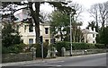
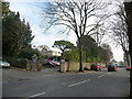
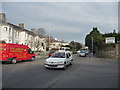
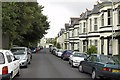
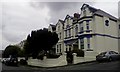
Photos of PL3 5AR


Area Information
Living in PL3 5AR means residing within a compact residential cluster that covers just 1.0 hectare. This small area currently supports a population of 1,516 residents, creating a closely knit environment where neighbours are never far apart. The location sits within the PL3 postcode district in England, offering a specific sense of place for those who prefer a contained neighbourhood over sprawling suburbs. Daily life here is defined by proximity; the built-up area is dense enough to foster community interaction yet small enough to navigate easily by foot or short car journeys. You can expect a quiet existence with little traffic congestion inside the immediate bounds of the postcode. The size of the area suggests a cohesive community where local events and amenities serve a defined group rather than a diffuse city-wide population. For anyone considering homes in PL3 5AR, the tangible reality is a tight-knit district where the scale of the community matches the modest footprint of the land. This setting provides a predictable routine with a clear understanding of your immediate surroundings.
- Area Type
- Postcode
- Area Size
- 1.0 hectares
- Population
- 1516
- Population Density
- 7197 people/km²
The housing landscape in PL3 5AR is defined by a near-even split between owners and renters, with home ownership standing at exactly 50%. This metric indicates a balanced market where neither buying nor renting overwhelmingly dominates the local economy. Houses are the primary type of accommodation available, which signals a stock of detached or semi-detached properties rather than apartment complexes. Buyers looking at homes in this postcode should expect a stock composed mainly of traditional residential structures. The relatively small size of the area, covering just 1.0 hectare, limits the volume of available properties within the immediate boundaries. Consequently, the local market relies heavily on the immediate surroundings and nearby streets for additional inventory. For prospective purchasers, this means the selection within PL3 5AR itself may be narrow, requiring a focus on the wider PL3 district to find suitable options. The 50% ownership rate suggests a steady turnover of properties due to life changes such as upgrades or down-sizing. This mixed ownership dynamic can create opportunities for both first-time buyers and those seeking to invest in the area.
House Prices in PL3 5AR
Showing 6 properties
| Address | Type | Beds | Baths | Last Sale Price | Last Sale Date | |
|---|---|---|---|---|---|---|
| Seymour House, Seymour Road, Mannamead, Plymouth, PL3 5AR | house | - | - | £1,700,000 | Feb 2019 | |
| Rockville, Seymour Road, Mannamead, Plymouth, PL3 5AR | Detached | 5 | 3 | £1,000,000 | Oct 2016 | |
| Poltair, Seymour Road, Mannamead, Plymouth, PL3 5AR | Flat | 1 | 1 | £590,000 | Jan 2003 | |
| Springfield, Seymour Road, Mannamead, Plymouth, PL3 5AR | Detached | - | - | £350,000 | Sep 2000 | |
| Rothbury, Seymour Road, Mannamead, Plymouth, PL3 5AR | Maisonette | - | - | £82,400 | Mar 1997 | |
| Chieveley, Seymour Road, Mannamead, Plymouth, PL3 5AR | Flat | 3 | 2 | - | - |
Energy Efficiency in PL3 5AR
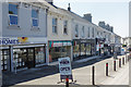
Residents of PL3 5AR enjoy convenient access to a range of amenities within practical reach of their homes. Retail options include Tesco Plymouth, Tesco Mutley, and a Co-op Mutley, ensuring that daily grocery shopping and household essentials are nearby. For travel connections, there are five rail stations nearby, including Plymouth Railway Station, Devonport Railway Station, and Dockyard Railway Station. These stations provide regular services for commuters heading out to other parts of the region or country. Sea travel is facilitated by five ferry terminals, such as Plymouth Landing Stage, Plymouth Mount Batten Ferry Landing, and Plymouth Ferry Terminal, offering links across the harbour and to other coastal destinations. Air travel is supported by Plymouth City Airport, with two facilities listed in the immediate vicinity for general aviation needs. This density of transport and retail options means you do not need to travel far for basic requirements. The availability of major supermarkets and multiple station terminals integrates PL3 5AR into the wider urban fabric of Plymouth. Your daily routine can be planned around these confirmed services, knowing they are established and operational.
Amenities
Schools
Families considering living in PL3 5AR have access to Western College Preparatory School as a key educational option nearby. This institution operates as an independent school, offering an alternative to the state sector for children in the catchment area. The presence of an independent school indicates a choice-based environment where parents can opt for private education if it aligns with their preferences and budget. While public school data is not detailed in the immediate vicinity, the existence of this specific institution provides a clear educational pathway for local residents. You can investigate Ofsted ratings and admission criteria for Western College Preparatory School directly, as the school operates with its own governance rather than through local authority control. The mix of school types here means that parents have the opportunity to choose between state and independent education for their children. For households in PL3 5AR, the proximity to this named school is a factual benefit to note when evaluating your location. Research into the specific curriculum and costs of this school will be necessary for families making school-based decisions.
| Rank | School | Type | Entry gender | Ages |
|---|
Explore more schools in this area
Go to Schools tabDemographics
The community in PL3 5AR is dominated by adults, with the median age recorded at 47 years. Most residents fall into the 30-64 age range, indicating a neighbourhood populated by established households rather than young students or retirement populations. This age profile often correlates with families in the middle stages of their property journey or individuals who have built stability in the region. Home ownership stands at 50%, meaning half of the residents own their homes outright or with a mortgage while the other half likely rents. Houses form the predominant form of accommodation, suggesting a traditional street scene rather than high-rise living or flats. The demographic composition is largely White, reflecting a community with a specific cultural background. You should be aware that with a population density reaching 149,736 people per square kilometre, the living space per individual is compact. This density influences the daily rhythm of the area, creating an environment where residential units are close together. The data confirms a stable, adult-centric population structure typical of mature residential zones in Plymouth.
Household Size
Accommodation Type
Tenure
Ethnic Group
Religion
Household Composition
Age
Household Deprivation
NS-SEC
Explore more demographic insights in this area
Go to Demographics tabPlanning
Planning Constraints
- Flood RiskPremium
- Ramsar Wetland SitesPremium
- Area of Outstanding Natural BeautyPremium
- Protected Nature ReservePremium
- Protected WoodlandPremium