Area Overview for PL12 4QT
Photos of PL12 4QT
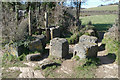

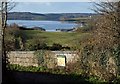
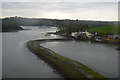
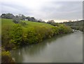
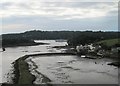
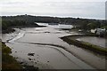
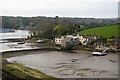
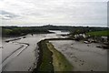
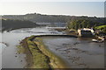

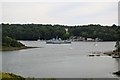
100 photos from this area
Area Information
Key information about the PL12 4QT including its size, population, and administrative classification.
- Area Type
- Postcode
- Area Size
- 60.3 hectares
- Population
- 1218
- Population Density
- 119 people/km²
House Prices in PL12 4QT
21
Properties
£504,227
Average Sold Price
£141,000
Lowest Price
£2,250,000
Highest Price
Showing 21 properties
| Address | Type | Beds | Baths | Last Sale Price | Last Sale Date | |
|---|---|---|---|---|---|---|
| Elanora, Antony Passage, Saltash, PL12 4QT | Detached | 4 | 2 | £375,000 | Sep 2024 | |
| The Old Mill, Antony Passage, Saltash, PL12 4QT | Detached | 4 | 2 | £2,250,000 | Jan 2023 | |
| Waters Edge, Antony Passage, Saltash, PL12 4QT | Cottage | 3 | 2 | £430,000 | Mar 2021 | |
| Keramenez, Antony Passage, Saltash, PL12 4QT | Detached | 3 | 3 | £141,000 | Aug 2019 | |
| River View, Antony Passage, Saltash, PL12 4QT | house | - | - | £605,000 | Jul 2017 | |
| Mariner's Muse, Antony Passage, Saltash, PL12 4QT | Detached | 3 | 3 | £220,000 | Mar 2013 | |
| Ferry House, Antony Passage, Saltash, PL12 4QT | house | 3 | - | £400,000 | Jan 2013 | |
| Heron Cottage, Antony Passage, Saltash, PL12 4QT | Semi-detached | - | - | £390,000 | Jul 2007 | |
| Jupiter Cottage, Antony Passage, Saltash, PL12 4QT | Terraced | 2 | 1 | £375,000 | Dec 2006 | |
| Curlew House, Antony Passage, Saltash, PL12 4QT | Detached | 4 | 2 | £218,000 | Aug 2002 |
Page 1 of 3
Energy Efficiency in PL12 4QT
Amenities
Schools
| Rank | School | Type | Entry gender | Ages |
|---|
Explore more schools in this area
Go to Schools tabDemographics
Household Size
Two person
most common
Accommodation Type
Houses
most common
Tenure
92
majority
Ethnic Group
White
most common
Religion
N/A
most common
Household Composition
N/A
most common
Age
47
median
Adults (30-64 years)
most common
Household Deprivation
N/A
with no deprivation
NS-SEC
42
in Lower managerial occupations
Explore more demographic insights in this area
Go to Demographics tabPlanning
Planning Constraints
- Flood RiskPremium
- Ramsar Wetland SitesPremium
- Area of Outstanding Natural BeautyPremium
- Protected Nature ReservePremium
- Protected WoodlandPremium