Area Overview for PL12 4AT
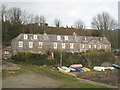
Photos of PL12 4AT


Area Information
Living in PL12 4AT means residing in a compact residential cluster defined by a specific postcode covering just 25.4 hectares. You will find this location to be distinctly characterised by its small scale and high density, with a population of 1,278 people packed into an area with a density of 5,035 people per square kilometre. This cluster represents a very specific neighbourhood rather than a broad district, offering a close-knit environment where local connections are naturally frequent. The area sits within the broader context of the PL12 postcode, which serves as a foundation for those seeking homes in this specific pocket of England. Daily life here is shaped by this concentration, where the limited land size ensures that the community feels immediate and accessible. While the area lacks the spread of larger towns, its focused nature creates a sense of locality that can be appealing to residents who prefer a contained living space. The environment is efficient, with services and neighbours situated within a very short radius due to the small geographical footprint.
- Area Type
- Postcode
- Area Size
- 25.4 hectares
- Population
- 1278
- Population Density
- 1781 people/km²
The property market in PL12 4AT is fundamentally characterised by the predominance of terraced or semi-detached housing stock, although the data lists the primary accommodation type as Houses. This classification typically encompasses semi-detached and detached properties common in post-war residential clusters. A significant majority of residents, amounting to 61 per cent, own their homes, which points strongly towards an owner-occupied market that has seen steady investment over the years. You are rarely looking at a high-volume rental sector here, as the existing housing stock is largely settled into permanent households. The small area size of 25.4 hectares limits the volume of properties available, creating a niche market for homes in this specific postcode. Potential buyers should understand that competition may be high for a limited number of listings due to the high home ownership rate among locals. The housing stock reflects the needs of adults aged 30 to 64, suggesting a focus on established family homes rather than micro-apartments or luxury conversions.
House Prices in PL12 4AT
Showing 10 properties
| Address | Type | Beds | Baths | Last Sale Price | Last Sale Date | |
|---|---|---|---|---|---|---|
| Maryfield View, Wearde Road, St Stephens, PL12 4AT | Detached | 4 | 3 | £600,000 | Aug 2017 | |
| Cliff Cottage, Wearde Road, St Stephens, PL12 4AT | Cottage | 3 | - | £640,000 | Jul 2009 | |
| Wearde Quay, Wearde Road, St Stephens, PL12 4AT | Detached | 4 | - | - | - | |
| Wearde Barn, Wearde Road, St Stephens, PL12 4AT | Detached | - | - | - | - | |
| 3, Wearde End Cottage, Wearde Quay, Wearde Road, St Stephens, PL12 4AT | house | - | - | - | - | |
| 2, Wearde Quay, Wearde Road, St Stephens, PL12 4AT | house | - | - | - | - | |
| Limekiln Boathouse, Wearde Road, St Stephens, PL12 4AT | Office | - | - | - | - | |
| 1, Wearde Quay, Wearde Road, St Stephens, PL12 4AT | Farm | 3 | - | - | - | |
| The Annexe, Maryfield View, Wearde Road, St Stephens, PL12 4AT | Flat | - | - | - | - | |
| Diving Belle Mooring Contractor, The Limekiln Boathouse, Wearde Road, St Stephens, PL12 4AT | Office | - | - | - | - |
Energy Efficiency in PL12 4AT
The lifestyle of PL12 4AT relies on a short but practical reach to essential amenities, ensuring daily convenience without long commutes. For your shopping needs, five retail venues operate within practical reach, including Spar, Co-op Saltash, and Morrisons Daily Saltash located at numbers 36 and 38. These stores provide all the necessities for daily food and household purchases. Transport links are extensive, with five railway stations nearby, including Saltash Railway Station, St Budeaux Victoria Road Railway Station, and St Budeaux Ferry Road Railway Station. You also have access to five ferry terminals such as Torpoint Ferry Terminal and Cawsand Beach Ferry Landing Pier, which connects you to nearby coastlines. Furthermore, two airports are listed in the vicinity, providing options for travel via Plymouth City Airport. While the area itself focuses on housing, these nearby facilities create a convenient hub for work, leisure, and travel. This blend of retail and transport hubs means you can manage most of your life needs without venturing far from home.
Amenities
Schools
| Rank | School | Type | Entry gender | Ages |
|---|
Explore more schools in this area
Go to Schools tabDemographics
The community in PL12 4AT is dominated by adults, with the most common age range falling between 30 and 64 years. Residents here are generally in the middle stages of their careers or families, reflecting a median age of 47 years. This demographic profile suggests a neighbourhood established by upwardly mobile adults rather than young students or retirees. Home ownership is a defining feature of daily life, with 61 per cent of residents owning their homes outright or with a mortgage. This majority ownership rate indicates a stable, established community rather than one defined by transient renting. The accommodation type is almost exclusively houses, meaning you will find detached or semi-detached structures rather than flats or terraced housing blocks typical of denser urban centres. The population is predominantly White, aligning with the broader demographic trends of the region. These figures combine to create a community where long-term residents value stability and family-oriented living arrangements.
Household Size
Accommodation Type
Tenure
Ethnic Group
Religion
Household Composition
Age
Household Deprivation
NS-SEC
Explore more demographic insights in this area
Go to Demographics tabPlanning
Planning Constraints
- Flood RiskPremium
- Ramsar Wetland SitesPremium
- Area of Outstanding Natural BeautyPremium
- Protected Nature ReservePremium
- Protected WoodlandPremium