Area Overview for PL10 1PA
Photos of PL10 1PA

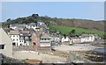
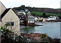
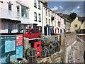
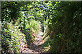

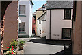
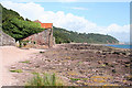


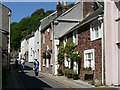
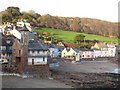
100 photos from this area
Area Information
Key information about the PL10 1PA including its size, population, and administrative classification.
- Area Type
- Postcode
- Area Size
- 3.8 hectares
- Population
- 1735
- Population Density
- 76 people/km²
House Prices in PL10 1PA
28
Properties
£317,859
Average Sold Price
£99,950
Lowest Price
£489,000
Highest Price
Showing 28 properties
| Address | Type | Beds | Baths | Last Sale Price | Last Sale Date | |
|---|---|---|---|---|---|---|
| Endfield, New Road, Cawsand, PL10 1PA | Bungalow | 3 | 1 | £489,000 | May 2024 | |
| Meo Voto, New Road Close, Cawsand, PL10 1PA | Semi-detached | 3 | 2 | £460,000 | Feb 2024 | |
| Tynewydd, New Road, Cawsand, PL10 1PA | Land | - | - | £440,000 | Oct 2022 | |
| Trenhayle, New Road Close, Cawsand, PL10 1PA | Semi-detached | 4 | 2 | £415,000 | Sep 2021 | |
| Colebrooke, New Road, Cawsand, PL10 1PA | Detached | 3 | 2 | £435,000 | Nov 2019 | |
| 4 New Road, Cawsand, PL10 1PA | Bungalow | 3 | 1 | £262,500 | Oct 2017 | |
| Old Police House, 7 New Road, Cawsand, PL10 1PA | Bungalow | - | - | £340,000 | Sep 2011 | |
| Wivelshire House, New Road, Cawsand, PL10 1PA | house | - | - | £350,000 | Feb 2005 | |
| 3 New Road, Cawsand, PL10 1PA | Bungalow | 3 | 2 | £99,950 | Feb 2002 | |
| Fort Cottage, New Road, Cawsand, PL10 1PA | Bungalow | 4 | 1 | £105,000 | Oct 2000 |
Page 1 of 3
Energy Efficiency in PL10 1PA
Amenities
Schools
| Rank | School | Type | Entry gender | Ages |
|---|
Explore more schools in this area
Go to Schools tabDemographics
Household Size
Two person
most common
Accommodation Type
Houses
most common
Tenure
71
majority
Ethnic Group
White
most common
Religion
N/A
most common
Household Composition
N/A
most common
Age
47
median
Adults (30-64 years)
most common
Household Deprivation
N/A
with no deprivation
NS-SEC
39
in Lower managerial occupations
Explore more demographic insights in this area
Go to Demographics tabPlanning
Planning Constraints
- Flood RiskPremium
- Ramsar Wetland SitesPremium
- Area of Outstanding Natural BeautyPremium
- Protected Nature ReservePremium
- Protected WoodlandPremium