Area Overview for EX31 1DG
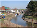
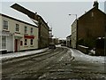
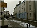
Photos of EX31 1DG


Area Information
Living in EX31 1DG means inhabiting a tightly packed residential cluster in England, where 1,684 people reside across just 694 square metres. This density creates a compact, community-focused environment, though it also means limited space for expansion. The area is defined by its proximity to essential services, with two railway stations—Barnstaple and Chapelton—within practical reach. Nearby, the Ashleigh CofE Primary School provides a local education hub, while retail options like M&S Barnstaple and Tesco Barnstaple cater to daily needs. The demographic profile suggests a mature population, with a median age of 47 and most residents aged 30–64. This mix of older adults and families contributes to a steady, stable community rhythm, where routine and familiarity shape daily life. However, the high population density and small area size mean that living here requires adaptability to shared spaces and close neighbourly interactions. For those prioritising convenience and proximity to services, EX31 1DG offers a functional, if intimate, lifestyle.
- Area Type
- Postcode
- Area Size
- 694 m²
- Population
- 1684
- Population Density
- 4182 people/km²
The property market in EX31 1DG is characterised by a low home ownership rate of 23%, suggesting that the majority of properties are rented rather than owned. The accommodation type is predominantly flats, a reflection of the area’s small size and high density. This configuration implies a limited housing stock, with little scope for expansion or new developments. For buyers, this means that available properties are likely to be in existing flats, which may be more suited to individuals or small families rather than larger households. The proximity to amenities like schools, rail stations, and retail hubs could make the area attractive for investors seeking rental income, though the high population density may also drive up competition for available units. Buyers should consider the compact nature of the area and its reliance on shared spaces when evaluating properties.
House Prices in EX31 1DG
Showing 1 properties
| Address | Type | Beds | Baths | Last Sale Price | Last Sale Date | |
|---|---|---|---|---|---|---|
| North Devon Council, Lynton House, Commercial Road, Barnstaple, EX31 1DG | office_workshop | - | - | - | - |
Energy Efficiency in EX31 1DG
Residents of EX31 1DG have access to a range of amenities within practical reach, including retail outlets like M&S Barnstaple, Tesco Barnstaple, and Iceland Barnstaple, which cater to everyday shopping needs. The area’s proximity to two railway stations and ferry landings at Instow and Appledore adds to its convenience, enabling easy travel to nearby towns or coastal destinations. While the data does not mention parks or leisure facilities, the presence of multiple transport options and retail hubs suggests a lifestyle focused on accessibility and practicality. The compact nature of the area means that amenities are closely clustered, reducing the need for long commutes. However, the lack of detailed information on recreational spaces or dining options leaves some aspects of the local lifestyle undefined.
Amenities
Schools
The nearest schools to EX31 1DG include Ashleigh CofE (VC) Primary School and Ashleigh CofE Primary School, both of which are primary institutions. The second school holds an Ofsted rating of ‘good’, indicating a satisfactory standard of education. The presence of two primary schools within the area provides families with options for their children’s early education, though no secondary schools are listed in the data. This suggests that families may need to travel further for secondary education, which could be a consideration for those prioritising a comprehensive local school network. The availability of primary education within walking or short driving distance is a practical advantage for parents, reducing the need for long commutes.
| Rank | School | Type | Entry gender | Ages |
|---|
Explore more schools in this area
Go to Schools tabDemographics
The community in EX31 1DG is predominantly composed of adults aged 30–64, with a median age of 47. This suggests a population skewed towards middle-aged individuals, likely with established careers and families. Home ownership is low at 23%, indicating that most residents rent their properties, which may reflect the area’s limited housing stock and high demand. The accommodation type is almost exclusively flats, a feature that aligns with the area’s compact footprint. The predominant ethnic group is White, though no specific data on diversity or deprivation is provided. The population density—2.4 million people per square kilometre—places this area among the most densely populated in England, which can influence the pace of life and the availability of private space. For residents, this density fosters a tightly knit community but may also contribute to a sense of overcrowding or limited personal space.
Household Size
Accommodation Type
Tenure
Ethnic Group
Religion
Household Composition
Age
Household Deprivation
NS-SEC
Explore more demographic insights in this area
Go to Demographics tabPlanning
Planning Constraints
- Flood RiskPremium
- Ramsar Wetland SitesPremium
- Area of Outstanding Natural BeautyPremium
- Protected Nature ReservePremium
- Protected WoodlandPremium