Area Overview for EX2 9ES
Photos of EX2 9ES


Area Information
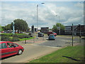
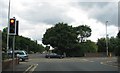
Living in EX2 9ES means being part of a tightly knit residential cluster in England, where 1,555 residents occupy just 2,206 square metres. The area’s population density of 704,788 people per square kilometre reflects its compact nature, blending urban convenience with a small-scale community feel. This postcode is served by multiple rail stations, including Exeter St Thomas and Exeter Central, offering easy access to regional hubs. Nearby, the Topsham Ferry Landings provide water transport links, while Exeter International Airport is within reach for those needing air travel. The area’s proximity to retail outlets like Aldi and Iceland, along with its mix of primary schools and low crime rates, makes it appealing for families. With a median age of 47 and a strong presence of adults aged 30–64, the community balances stability with practical amenities. While the high population density may feel intimate, the area’s infrastructure ensures daily life remains efficient, from broadband connectivity rated 93/100 to accessible public transport.
- Area Type
- Postcode
- Area Size
- 2206 m²
- Population
- 1555
- Population Density
- 7578 people/km²
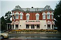
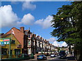
EX2 9ES is primarily an owner-occupied area, with 58% of homes owned by residents and the remaining 42% likely rented. The accommodation type is predominantly houses, which is uncommon in high-density urban areas but aligns with the postcode’s small-scale, residential character. This suggests a market skewed towards family homes rather than apartments or flats, which may appeal to buyers seeking traditional housing. The limited area size of 2,206 square metres means the housing stock is constrained, potentially driving up property values or creating competition among buyers. For those considering the area, the focus on houses indicates a demand for space and privacy, even within a densely populated postcode. Proximity to rail networks and retail amenities adds to the area’s appeal, though buyers should weigh the high population density against the benefits of local infrastructure.
House Prices in EX2 9ES
Showing 6 properties
| Address | Type | Beds | Baths | Last Sale Price | Last Sale Date | |
|---|---|---|---|---|---|---|
| 9 Princes Street East, Exeter, EX2 9ES | Semi-detached | 3 | 2 | £445,000 | Mar 2025 | |
| 5 Princes Street East, Exeter, EX2 9ES | Semi-detached | 3 | 1 | £314,000 | Jan 2020 | |
| 3 Princes Street East, Exeter, EX2 9ES | house | 3 | - | £225,000 | Aug 2013 | |
| THE MANOR, 1 PRINCES STREET EAST, Exeter, EX2 9ES | Unknown | 4 | - | £135,000 | Sep 2002 | |
| 1 Princes Street East, Exeter, EX2 9ES | house | - | - | £135,000 | Sep 2002 | |
| 7 Princes Street East, Exeter, EX2 9ES | house | - | - | £115,000 | Apr 2001 |
Energy Efficiency in EX2 9ES
Residents of EX2 9ES have access to a range of amenities within easy reach. The area is served by five retail outlets, including The Southern Co-operative, Aldi, and Iceland, ensuring everyday shopping needs are met. Rail stations like Exeter Central and Marsh Barton provide links to major employment hubs, while ferry landings at Topsham offer scenic travel options along the river. Exeter International Airport is within reach for those needing air travel. The presence of these amenities creates a practical lifestyle, blending local convenience with regional connectivity. The mix of retail, transport, and leisure options supports both daily routines and occasional outings, contributing to a balanced quality of life.
Amenities
Schools
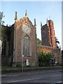
The nearest school to EX2 9ES is St Thomas Primary School, which serves the area’s children with a primary education. The school holds a ‘good’ Ofsted rating, indicating a satisfactory standard of teaching and facilities. As the only listed school in the data, it is the primary educational option for local families. The presence of a single primary school suggests a focus on early education, though parents may need to consider secondary schooling options in nearby towns. The school’s rating ensures it meets national standards, providing reassurance for families prioritising quality education. Given the area’s population of 1,555, the school likely accommodates a significant proportion of local children, reinforcing its role as a community anchor.
| Rank | School | Type | Entry gender | Ages |
|---|
Explore more schools in this area
Go to Schools tabDemographics
The population of EX2 9ES is predominantly adults aged 30–64, with a median age of 47. This suggests a community of established professionals and families, rather than a younger or elderly demographic. Home ownership stands at 58%, with the majority of properties being houses rather than flats or apartments. The predominant ethnic group is White, reflecting a homogenous demographic profile. The absence of specific deprivation data means the area’s quality of life is inferred through its amenities and safety metrics. With 42% of households likely renting, the area supports both long-term residents and those seeking temporary housing. The age distribution indicates a mature population, which may influence local services and social dynamics. This demographic structure aligns with a community prioritising stability, reflected in the low crime score of 80/100 and the presence of a well-regarded primary school.
Household Size
Accommodation Type
Tenure
Ethnic Group
Religion
Household Composition
Age
Household Deprivation
NS-SEC
Explore more demographic insights in this area
Go to Demographics tabPlanning
Planning Constraints
- Flood RiskPremium
- Ramsar Wetland SitesPremium
- Area of Outstanding Natural BeautyPremium
- Protected Nature ReservePremium
- Protected WoodlandPremium