Area Overview for EX2 9AL
Photos of EX2 9AL


Area Information
Living in EX2 9AL means inhabiting a tightly packed residential cluster in England, where 1,555 people reside across 5,580 square metres. The area’s density is striking — over 278,000 people per square kilometre — creating a compact, closely knit community. This postcode is not a sprawling suburb but a focused cluster of homes, likely centred around local amenities and transport links. The median age of 47 suggests a stable, mature population, with most residents aged 30–64, indicating a mix of families and established professionals. While the area’s small size limits expansion, its proximity to Exeter’s infrastructure — including railway stations and retail hubs — offers convenience. However, the critical flood risk score of 100 highlights a major challenge, requiring careful consideration for homeowners. Despite this, the low crime risk score of 80 and the presence of schools and transport options suggest a functional, if densely populated, environment for those prioritising accessibility over space.
- Area Type
- Postcode
- Area Size
- 5580 m²
- Population
- 1555
- Population Density
- 7578 people/km²
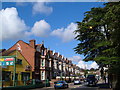
The property market in EX2 9AL is characterised by a 58% home ownership rate, with houses being the predominant accommodation type. This suggests a market skewed towards owner-occupied properties rather than a high proportion of rental units. In a small postcode area like this, the limited number of homes means the stock is likely tightly held, with fewer new developments. The focus on houses may appeal to families seeking space, though the area’s compact size may restrict availability. Buyers should consider the implications of high population density — while it ensures proximity to amenities, it also limits potential for expansion or new builds. The flood risk score of 100 adds a critical caveat, requiring careful evaluation of property resilience. For those prioritising stability and proximity to transport, the area’s railway links and retail access may outweigh its spatial constraints.
House Prices in EX2 9AL
Showing 26 properties
| Address | Type | Beds | Baths | Last Sale Price | Last Sale Date | |
|---|---|---|---|---|---|---|
| 9 Princes Street North, Exeter, EX2 9AL | Retail | 4 | 3 | £395,000 | Jun 2022 | |
| 12 Princes Street North, Exeter, EX2 9AL | Terraced | 3 | 1 | £10,000 | Aug 2021 | |
| 22 Princes Street North, Exeter, EX2 9AL | Terraced | 3 | 1 | £198,000 | Dec 2016 | |
| 24 Princes Street North, Exeter, EX2 9AL | Terraced | 3 | 1 | £198,000 | Feb 2016 | |
| 20 Princes Street North, Exeter, EX2 9AL | Terraced | 3 | - | £175,000 | Jan 2014 | |
| 23 Princes Street North, Exeter, EX2 9AL | Terraced | 3 | - | £145,000 | May 2013 | |
| 15 Princes Street North, Exeter, EX2 9AL | house | 4 | - | £245,000 | May 2010 | |
| 26 Princes Street North, Exeter, EX2 9AL | Terraced | - | - | £190,000 | Jul 2008 | |
| 7 Princes Street North, Exeter, EX2 9AL | house | 1 | 1 | £260,000 | Jul 2008 | |
| 8 Princes Street North, Exeter, EX2 9AL | house | - | - | £185,000 | Jun 2008 |
Energy Efficiency in EX2 9AL
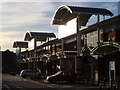
The lifestyle in EX2 9AL is shaped by its proximity to retail, transport, and leisure options. Within practical reach are five retail outlets, including Aldi St, Iceland Alphington, and M&S Exebridges Exeter SF, offering everyday shopping needs. The area’s railway network connects residents to Exeter’s central stations, while the nearby Exeter International Airport provides regional and international travel access. For water-based transport, three ferry landings — Topsham Lock, Topsham, and Turf Lock Inn — offer scenic routes along the river. Though the data does not specify parks or leisure facilities, the presence of multiple retail and transport hubs suggests a convenience-focused lifestyle. The compact nature of the area means amenities are closely clustered, reducing travel time for daily errands. However, the absence of detailed information on green spaces or recreational areas leaves room to explore local parks or nearby natural attractions.
Amenities
Schools
The nearest school to EX2 9AL is St Thomas Primary School, which serves the local community with primary education. The school holds an Ofsted rating of ‘good’, indicating a satisfactory standard of teaching and facilities. As the only school listed in the data, it is the primary educational option for nearby residents. The absence of secondary schools or additional educational institutions suggests families may need to travel beyond the immediate area for higher education. However, the proximity of St Thomas Primary School to the postcode makes it a convenient choice for younger children. The ‘good’ rating implies that parents can expect a functional school environment, though further details on curriculum or extracurriculars are not provided. For buyers prioritising schools, this single option may necessitate a broader search for secondary education.
| Rank | School | Type | Entry gender | Ages |
|---|
Explore more schools in this area
Go to Schools tabDemographics
The community in EX2 9AL is predominantly composed of adults aged 30–64, with a median age of 47. This reflects a mature population, likely with established careers and family commitments. Home ownership stands at 58%, indicating a mix of owner-occupied properties and rental units, though the exact proportion of renters is not specified. The accommodation type is primarily houses, which is notable in a small postcode area, suggesting a focus on single-family homes rather than flats or apartments. The predominant ethnic group is White, though no specific data on diversity or deprivation levels is provided. The high population density — over 278,000 people per square kilometre — implies a tightly packed settlement, which may influence local services and infrastructure demands. For buyers, this demographic profile suggests a stable, low-turnover market, but the lack of detailed diversity data leaves room for further inquiry.
Household Size
Accommodation Type
Tenure
Ethnic Group
Religion
Household Composition
Age
Household Deprivation
NS-SEC
Explore more demographic insights in this area
Go to Demographics tabPlanning
Planning Constraints
- Flood RiskPremium
- Ramsar Wetland SitesPremium
- Area of Outstanding Natural BeautyPremium
- Protected Nature ReservePremium
- Protected WoodlandPremium