Area Overview for EX2 7RY
Photos of EX2 7RY


Area Information
Living in EX2 7RY offers a compact, residential environment nestled in a small cluster of homes. The area spans 5 hectares and is home to 2080 people, translating to a population density of 953 people per square kilometre. This suggests a closely knit community, where daily life is likely shaped by local interactions and shared spaces. The postcode is characterised by a predominance of houses, reflecting a more traditional, family-oriented living arrangement. With a median age of 47, the area’s residents are largely adults aged 30–64, indicating a stable demographic profile. While the data does not specify local landmarks or cultural hubs, the proximity to rail stations, retail outlets, and ferry services hints at practical connectivity. For those considering EX2 7RY, the balance of residential tranquillity and accessible amenities may appeal to buyers seeking a settled lifestyle without sacrificing convenience.
- Area Type
- Postcode
- Area Size
- 5.0 hectares
- Population
- 2080
- Population Density
- 953 people/km²
The property market in EX2 7RY is largely owner-occupied, with 72% of homes owned by their residents. This high rate of home ownership indicates a stable and established community, where properties are likely to be held for the long term. The accommodation type is predominantly houses, which suggests a market skewed towards larger, family-friendly properties rather than apartments or flats. Given the area’s small size—just 5 hectares—the housing stock is limited, meaning buyers may need to consider nearby areas for additional options. The presence of houses implies a focus on private, spacious living, which may appeal to those seeking a traditional, low-density environment. However, the limited size of the postcode also means that the immediate surroundings are critical for potential buyers exploring the local market.
House Prices in EX2 7RY
Showing 1 properties
| Address | Type | Beds | Baths | Last Sale Price | Last Sale Date | |
|---|---|---|---|---|---|---|
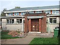
| Exeter Police Station, Sidmouth Road, Exeter, EX2 7RY | emergency_services | - | - | - | - |
Energy Efficiency in EX2 7RY
The lifestyle in EX2 7RY is shaped by its proximity to a range of amenities. Residents have access to major retail chains like M&S, Tesco, and Morrisons, ensuring everyday shopping needs are met without long journeys. The presence of ferry landings, including Topsham Ferry Landing and Turf Lock Inn Ferry Landing, suggests opportunities for leisurely water-based travel or commuting along the river. Rail stations such as Digby & Sowton and Pinhoe provide connections to nearby towns and cities, enhancing mobility. The area’s compact size means that these amenities are within practical reach, contributing to a convenient daily life. While the data does not specify parks or recreational spaces, the absence of planning constraints like AONB or protected woodlands implies potential for open spaces. The blend of retail, transport, and water access creates a lifestyle that balances practicality with accessibility.
Amenities
Schools
Residents of EX2 7RY have access to three educational institutions within practical reach: The Central Devon Personalised Learning Service, SchoolsCompany Central Devon Academy, and Stansfield Academy. While the data does not specify Ofsted ratings for these schools, their presence reflects a range of educational options for families. The mix of school types—categorised as "other"—may indicate a blend of specialist or alternative educational approaches. For parents, this variety could offer flexibility in choosing a school that aligns with their child’s needs. The proximity of these institutions to the area suggests that families do not need to travel far for schooling, which is a key consideration for homebuyers prioritising convenience. However, the absence of detailed performance data means further research would be needed to assess the quality of education available.
| Rank | School | Type | Entry gender | Ages |
|---|
Explore more schools in this area
Go to Schools tabDemographics
The community in EX2 7RY is predominantly composed of adults aged 30–64, with a median age of 47. This suggests a mature population, likely with established careers and families. Home ownership is high at 72%, indicating a stable housing market where most residents own their properties. The accommodation type is primarily houses, which aligns with the demographic’s preference for larger, private living spaces. The predominant ethnic group is White, reflecting a homogenous community. With a population density of 953 people per square kilometre, the area is moderately populated, allowing for a sense of community without overcrowding. The absence of specific deprivation data means the quality of life can be inferred from the availability of amenities, such as schools and transport links, which are within practical reach. This demographic profile suggests a focus on stability and long-term residency.
Household Size
Accommodation Type
Tenure
Ethnic Group
Religion
Household Composition
Age
Household Deprivation
NS-SEC
Explore more demographic insights in this area
Go to Demographics tabPlanning
Planning Constraints
- Flood RiskPremium
- Ramsar Wetland SitesPremium
- Area of Outstanding Natural BeautyPremium
- Protected Nature ReservePremium
- Protected WoodlandPremium