Area Overview for BS49 4AP
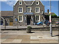
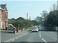
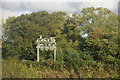
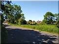
Photos of BS49 4AP


Area Information
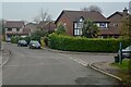
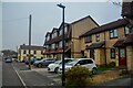
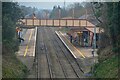
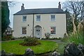
BS49 4AP is a small residential postcode in North Somerset, encompassing the village of Yatton. With a population of 2167 spread across 5792 m², it is a compact area characterised by a mix of historical significance and modern commuter appeal. Situated 11 miles south-west of Bristol, Yatton lies on the North Somerset Levels, a landscape of low-lying land shaped by watercourses and drained ground known locally as a “batch.” This geography has influenced its development, with early settlements emerging around Cadbury Hill, an Iron Age and Roman site. Today, the area is a commuter hub for Bristol, served by the Bristol & Exeter Railway, which opened in the 1840s. Daily life here balances rural tranquillity with proximity to urban amenities, offering residents a blend of historical heritage and practical connectivity. The village’s compact size means it is walkable, with nearby rail stations and retail options within practical reach. Its character is defined by its low population density, which contributes to a quiet, community-focused atmosphere.
- Area Type
- Postcode
- Area Size
- 5792 m²
- Population
- 2167
- Population Density
- 229 people/km²
The property market in BS49 4AP is dominated by owner-occupied homes, with 78% of residents living in properties they own. The accommodation type is primarily houses, reflecting the area’s small, residential nature. This suggests a limited housing stock, as the postcode covers only a small cluster of properties. The high home ownership rate indicates that most properties are long-term investments rather than rental assets, which may make the market less dynamic for buyers seeking short-term opportunities. For prospective buyers, the focus is on purchasing within this compact area, where availability is constrained by the small population and land size. The predominance of houses over flats or apartments means buyers should expect larger, more traditional properties. The market’s stability is likely influenced by the area’s low population density and historical character, which may appeal to those seeking a quieter, established community.
House Prices in BS49 4AP
No properties found in this postcode.
Energy Efficiency in BS49 4AP
Living in BS49 4AP offers access to a range of local amenities within practical reach. Retail options include Co-op Yatton, Tesco Congresbury, and Budgens Cleeve, providing everyday shopping needs. The area is served by four rail stations, including Yatton and Worle, facilitating travel to nearby towns and cities. A ferry service at Clevedon Pier adds to the recreational options, while Bristol Airport is within reach for regional travel. The presence of a primary school with an outstanding rating ensures quality education for families. The village’s historical character, including sites like Cadbury Hill, adds cultural depth to daily life. While the area is small, its amenities are sufficient for a low-key lifestyle, with a focus on community and convenience. The mix of retail, transport, and leisure options supports both practical needs and a relaxed pace of life.
Amenities
Schools
The nearest school to BS49 4AP is Chestnut Park Primary, a primary school with an outstanding Ofsted rating. This rating indicates high educational standards and effective teaching, which is a significant draw for families. The presence of a primary school within the area ensures that young children can access education locally, reducing the need for long commutes. While no secondary schools are listed in the data, the proximity to rail stations and nearby towns like Bristol suggests that secondary education options are accessible via transport links. The mix of school types—primarily primary—means that families may need to consider additional schooling arrangements for older children. However, the outstanding rating at Chestnut Park Primary provides a strong foundation for early education, supporting the area’s appeal to families.
| Rank | School | Type | Entry gender | Ages |
|---|
Explore more schools in this area
Go to Schools tabDemographics
The population of BS49 4AP is 2167, with a median age of 47, indicating a mature demographic. The majority of residents are adults aged 30–64, reflecting a stable, established community. Home ownership is high at 78%, suggesting a strong sense of local investment and long-term residency. The predominant accommodation type is houses, aligning with the area’s residential character. The predominant ethnic group is White, though specific data on diversity is not provided. The age profile and home ownership rate imply a community focused on family stability and long-term living, with fewer transient residents. The population density of 229 people per km² is relatively low, contributing to a less crowded environment compared to larger urban areas. This demographic structure supports a quiet, neighbourly atmosphere, with services and amenities tailored to local needs rather than large-scale commercialisation.
Household Size
Accommodation Type
Tenure
Ethnic Group
Religion
Household Composition
Age
Household Deprivation
NS-SEC
Explore more demographic insights in this area
Go to Demographics tabPlanning
Planning Constraints
- Flood RiskPremium
- Ramsar Wetland SitesPremium
- Area of Outstanding Natural BeautyPremium
- Protected Nature ReservePremium
- Protected WoodlandPremium