Area Overview for BS41 9FF
Photos of BS41 9FF
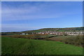
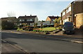
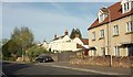
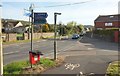
39 photos from this area
Area Information
Key information about the BS41 9FF including its size, population, and administrative classification.
- Area Type
- Postcode
- Area Size
- 1.6 hectares
- Population
- 2673
- Population Density
- 1435 people/km²
House Prices in BS41 9FF
45
Properties
£422,808
Average Sold Price
£227,000
Lowest Price
£715,000
Highest Price
Showing 45 properties
| Address | Type | Beds | Baths | Last Sale Price | Last Sale Date | |
|---|---|---|---|---|---|---|
| 24 Pear Tree Avenue, Long Ashton, BS41 9FF | Terraced | 3 | 2 | £500,000 | Aug 2024 | |
| 19 Pear Tree Avenue, Long Ashton, BS41 9FF | Detached | 5 | 3 | £715,000 | Jan 2024 | |
| 32 Pear Tree Avenue, Long Ashton, BS41 9FF | Terraced | 4 | 3 | £450,000 | Oct 2023 | |
| 38 Pear Tree Avenue, Long Ashton, BS41 9FF | Semi-detached | 3 | 1 | £425,000 | Jan 2023 | |
| 18 Pear Tree Avenue, Long Ashton, BS41 9FF | Terraced | 3 | 2 | £490,000 | Jan 2023 | |
| 11 Pear Tree Avenue, Long Ashton, BS41 9FF | Retail | 5 | 3 | £695,000 | Jun 2022 | |
| 14 Pear Tree Avenue, Long Ashton, BS41 9FF | house | - | - | £520,000 | Dec 2021 | |
| 6 Pear Tree Avenue, Long Ashton, BS41 9FF | Terraced | 3 | - | £415,000 | Sep 2021 | |
| 27 Pear Tree Avenue, Long Ashton, BS41 9FF | Terraced | 4 | 2 | £387,750 | Sep 2021 | |
| 16 Pear Tree Avenue, Long Ashton, BS41 9FF | Terraced | 5 | 3 | £525,000 | Jun 2021 |
Page 1 of 5
Energy Efficiency in BS41 9FF
Amenities
Schools
| Rank | School | Type | Entry gender | Ages |
|---|
Explore more schools in this area
Go to Schools tabDemographics
Household Size
Family (3-5 people)
most common
Accommodation Type
Houses
most common
Tenure
76
majority
Ethnic Group
White
most common
Religion
N/A
most common
Household Composition
N/A
most common
Age
47
median
Adults (30-64 years)
most common
Household Deprivation
N/A
with no deprivation
NS-SEC
51
in Lower managerial occupations
Explore more demographic insights in this area
Go to Demographics tabPlanning
Planning Constraints
- Flood RiskPremium
- Ramsar Wetland SitesPremium
- Area of Outstanding Natural BeautyPremium
- Protected Nature ReservePremium
- Protected WoodlandPremium