Area Overview for BS20 8ES
Photos of BS20 8ES

Area Information
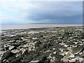
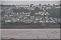
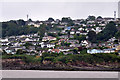
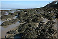
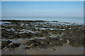
Living in BS20 8ES offers a quiet residential experience within a small cluster covering 16.7 hectares. This postcode sits on the northwestern fringe of Bristol, forming part of the Avonmouth and Lawrence Weston ward. The area hosts around 1,947 residents, creating a tight-knit community feel despite its proximity to major industrial zones. You will find yourself near the Severn flood plain to the west and bordering Blaise Castle estate to the east. The locality incorporates historical layers, from its origins as a hamlet within Henbury to its expansion with post-war council housing in the late 1940s. Kings Weston House, a Georgian mansion dating to 1712, stands nearby on over 200 acres of parkland, shielding parts of the area with historic grandeur. Your daily life balances proximity to Bristol's industrial heart with pockets of natural beauty. The area functions as a practical base for those working in nearby ports or further afield, given its location along the M5 corridor. While industrial influences are real, the immediate surroundings include protected nature reserves that add green space to the residential fabric. You are navigating a neighbourhood defined by specific boundaries, including Kingsweston Hill to the south. This setting provides a distinct identity separate from the urban core, appealing to buyers who value a grounded, community-focused atmosphere. The lifestyle here reflects a pragmatic approach to living, shaped by the area's industrial heritage and close connection to the River Severn.
- Area Type
- Postcode
- Area Size
- 16.7 hectares
- Population
- 1947
- Population Density
- 433 people/km²
BS20 8ES represents a distinct property market centred on house ownership. With 51 per cent home ownership, the area serves more owners than renters. This statistic highlights a stable market where residents have secured their living arrangements for the long term. The predominant accommodation type consists of houses, reflecting the area's evolution from a small hamlet into a residential cluster. You are not looking at a high-rise rental block district but rather a dedicated residential zone. This housing mix typically appeals to those seeking space and permanence rather than the fluidity of a rental sector. Proprietors in BS20 8ES have invested in homes that form part of a historic council estate background. The 1940s and 1950s council housing expansion defines much of the stock, providing a backdrop of established neighbourhoods rather than new developments. Buyers considering this postcode can expect a traditional property environment without the novelty of modern builds dominating the skyline. The small size of 16.7 hectares limits new construction options, preserving the character of the existing built environment. This concentration of houses means you face a market where stock is finite and values may remain stable. Local improvements, such as community hubs developed by Ambition Lawrence Weston, have influenced the desirability of specific streets within the cluster.
House Prices in BS20 8ES
Showing 4 properties
| Address | Type | Beds | Baths | Last Sale Price | Last Sale Date | |
|---|---|---|---|---|---|---|
| 2 Beechwood Drive, Portishead, BS20 8ES | Bungalow | 3 | - | £330,000 | Jun 2013 | |
| 1 Beechwood Drive, Portishead, BS20 8ES | Detached | - | - | £355,000 | Feb 2004 | |
| 3 Beechwood Drive, Portishead, BS20 8ES | Detached | - | - | £285,000 | Dec 2001 | |
| Aylwin, Beechwood Drive, Portishead, BS20 8ES | Detached | - | - | - | - |
Energy Efficiency in BS20 8ES
Residents of BS20 8ES benefit from a range of amenities within practical reach. Five retail outlets serve the immediate area, including Tesco Portishead W, Co-op Portishead, and Iceland Portishead. These supermarkets reduce the need for long trips to the city centre for daily groceries. You can also access three ferry services, such as Portishead Pier and Bristol Docks Ferry Landing, providing occasional leisure trips across the Bristol Channel. Three railway stations sit nearby, offering rail connections to five different hubs, including Nailsea & Backwell Railway Station. Your leisure options extend to significant green spaces and cultural sites. Blaise Castle Estate and its woods lie just to the east, offering extensive walking paths and wildlife viewing. Kings Weston House stands on over 200 acres of restored parkland, available for day visits or leisure walks. The area also hosts the Lawrence Weston Community Hub, a facility developed by Ambition Lawrence Weston to support local youth and families. This hub complements other community efforts focused on improving play facilities and social spaces. You will find a clear focus on family-friendly infrastructure, from new primary schools in the vicinity to organised community programmes.
Amenities
Schools
| Rank | School | Type | Entry gender | Ages |
|---|
Explore more schools in this area
Go to Schools tabDemographics
The community in BS20 8ES reflects a mature population profile with a median age of 47. Adults between 30 and 64 years make up the most common age range, suggesting a neighbourhood anchored by families and established workers. Home ownership stands at 51 per cent, indicating that roughly half of the households possess their dwellings outright rather than renting. This figure positions the area as a significant owner-occupied zone compared to citywide averages. You will primarily find houses as the dominant accommodation type, fitting the residential character of a cluster expanding from original hamlets. The area maintains a predominant White ethnic group, aligning with broader demographic trends for the local ward. With 16.7 hectares of land supporting 1,947 people, the population density reaches 433 people per square kilometre. This moderate density prevents the area from feeling overcrowded while ensuring local facilities remain within reasonable reach. The age structure supports local schools and community organisations, creating a stable environment for long-term residents. You should expect a quiet atmosphere where neighbours know each other, typical of a post-war estate that has evolved into a functioning residential suburb. The demographic makeup avoids extreme youth or elderly concentrations, favouring a balanced mix of working-age adults and ageing families. This stability plays a crucial role in the local economy and social cohesion of BS20 8ES.
Household Size
Accommodation Type
Tenure
Ethnic Group
Religion
Household Composition
Age
Household Deprivation
NS-SEC
Explore more demographic insights in this area
Go to Demographics tabPlanning
Planning Constraints
- Flood RiskPremium
- Ramsar Wetland SitesPremium
- Area of Outstanding Natural BeautyPremium
- Protected Nature ReservePremium
- Protected WoodlandPremium