Area Overview for BA2 6HP
Photos of BA2 6HP
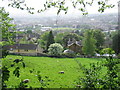
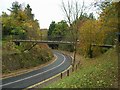
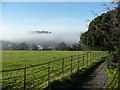
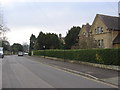
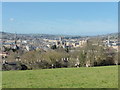
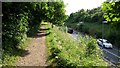
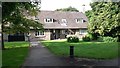

100 photos from this area
Area Information
Key information about the BA2 6HP including its size, population, and administrative classification.
- Area Type
- Postcode
- Area Size
- 3.6 hectares
- Population
- 4214
- Population Density
- 1522 people/km²
House Prices in BA2 6HP
8
Properties
£888,450
Average Sold Price
£580,000
Lowest Price
£1,225,000
Highest Price
Showing 8 properties
| Address | Type | Beds | Baths | Last Sale Price | Last Sale Date | |
|---|---|---|---|---|---|---|
| Hunters Lodge, North Road, Bathwick, Bath, BA2 6HP | Detached | 3 | 1 | £947,250 | Oct 2025 | |
| Haytor, North Road, Bathwick, Bath, BA2 6HP | Bungalow | - | - | £1,225,000 | Mar 2021 | |
| Hunters Spinney, North Road, Bathwick, Bath, BA2 6HP | Semi-detached | 4 | - | £1,050,000 | Oct 2014 | |
| Little Clarendon, North Road, Bathwick, Bath, BA2 6HP | house | - | - | £580,000 | Apr 2010 | |
| Brackenrigg, North Road, Bathwick, Bath, BA2 6HP | Detached | 4 | - | £640,000 | Jun 1999 | |
| Birchwood House, North Road, Bathwick, Bath, BA2 6HP | Semi-detached | - | - | - | - | |
| Silverwood, North Road, Bathwick, Bath, BA2 6HP | Detached | - | - | - | - | |
| Heydon House, North Road, Bathwick, Bath, BA2 6HP | Detached | - | - | - | - |
Energy Efficiency in BA2 6HP
Amenities
Schools
| Rank | School | Type | Entry gender | Ages |
|---|
Explore more schools in this area
Go to Schools tabDemographics
Household Size
Two person
most common
Accommodation Type
Houses
most common
Tenure
86
majority
Ethnic Group
White
most common
Religion
N/A
most common
Household Composition
N/A
most common
Age
22
median
Young Adults (15-29 years)
most common
Household Deprivation
N/A
with no deprivation
NS-SEC
15
in Lower managerial occupations
Explore more demographic insights in this area
Go to Demographics tabPlanning
Planning Constraints
- Flood RiskPremium
- Ramsar Wetland SitesPremium
- Area of Outstanding Natural BeautyPremium
- Protected Nature ReservePremium
- Protected WoodlandPremium