Area Overview for BA2 6HR
Photos of BA2 6HR

Area Information
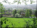
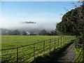
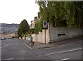
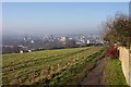
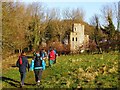
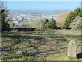
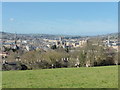
Living in BA2 6HR places you within the historic Bathwick Ward, a district that spans a specific residential cluster in the South West of England. You are situated east of central Bath, across the River Avon, at coordinates 51.38117, -2.352318. This postcode area covers a small residential cluster with a total population of 4,214 people. The location is defined by its urban Georgian character, blending elegant 18th-19th century architecture in Bath stone with streets like Great Pulteney Street and Sydney Place. While specific property size data is not explicitly listed, the area forms part of the larger Bath urban area and the Bath Conservation Area. You live in a community with deep historical roots, first mentioned as "Wiche" or "Wicke" in the Domesday Book of 1086 before becoming urbanised during the 18th century. The vicinity features notable features such as Pulteney Bridge, designed by Robert Adam, and historic sites including the Domesday mill site and the former Northgate Brewery. Daily life here involves being close to a university campus and enjoying access to the wider Bath urban area. The density allows for a manageable neighbourhood feel within a significant city setting.
- Area Type
- Postcode
- Area Size
- Not available
- Population
- 4214
- Population Density
- 1522 people/km²
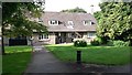
The property market in BA2 6HR is characterised by dominant home ownership. With 86% of homes owned by their inhabitants, this small postcode area functions more like established urban communities than typical student rentals. The primary accommodation type available here is houses, offering a substantial property stock for buyers seeking detached or semi-detached living. You are less likely to find purpose-built flats or high-density blocks within this specific BA2 6HR cluster compared to the wider BA1 postcode areas. This high ownership rate signals that the area attracts buyers who plan to settle long term. Prospective purchasers looking at this small area should expect a market driven by owner-occupiers rather than landlords. The presence of houses suggests that you may have more options for garden space or traditional urban residential living. This structure supports a stable local community where residents have invested in their specific properties. Buying here means joining a demographic that values property ownership within a historic urban setting.
House Prices in BA2 6HR
No properties found in this postcode.
Energy Efficiency in BA2 6HR
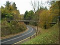
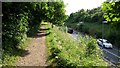
Your daily lifestyle in BA2 6HR is supported by practical retail and transport amenities within close proximity. You have five specific retail options nearby, including Tesco Bathwick, Co-op University of, and The Southern Co-operative Co. These shops provide essential groceries and daily necessities without requiring a long drive. Transport convenience is enhanced by rail services at Bath Spa Railway Station, Oldfield Park Railway Station, and Freshford Railway Station. These stations are among the five rail stations identified as being nearest to this area. The area benefits from being part of the wider Bath urban network, placing you near significant landmarks like Pulteney Bridge and the River Avon. You can walk to historic sites such as the Domesday mill site or the Bathwick St Mary Churchyard. The combination of grocery stores and railway access means you can manage household needs and commute efficiently. Living here provides a balance of urban accessibility and residential calm.
Amenities
Schools
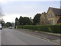
Families considering BA2 6HR have access to several educational institutions nearby, offering a mix of faith-based, state, and independent options. The nearest primary education option is Bathwick St Mary Church of England Primary School, providing a faith-led state education for younger children. You also find Bathwick St Mary Church School, which operates as an academy and holds a good Ofsted rating, ensuring quality state education. For those seeking private education, King Edward's School is available as an independent choice for families requiring alternative schooling arrangements. The presence of the University of Bath further enriches the local education landscape. This combination means you have state primary schools, an academically strong academy, and renowned independent schooling within practical reach. Children in the area can access an Ofsted-rated good school alongside high-level university facilities. The variety of school types ensures that residents with different educational philosophies can find suitable provision without needing to travel far outside the immediate neighbourhood.
| Rank | School | Type | Entry gender | Ages |
|---|
Explore more schools in this area
Go to Schools tabDemographics
The community in BA2 6HR reflects a distinct demographic profile dominated by young adults. You will find that the most common age range among residents is 15 to 29 years, aligning with a median age of just 22 years old. This indicates a neighbourhood heavily influenced by students and professionals drawn to the local university environment. Housing in this single postcode area primarily consists of houses, distinguishing it from areas dominated by flats or apartment blocks. Ownership levels are notably high, with 86% of homes in this cluster owned outright or through a mortgage. You are less likely to be renting compared to many other parts of the UK capital. The predominant ethnic group is White, forming the majority of the population in this specific ward. This demographic makeup contrasts with the wider national average, which often shows higher proportions of private renters and older age groups. The high ownership rate suggests stability and long-term investment in properties within this residential cluster. Families and couples with purchasing power seem to prefer this layout over flat-based accommodation.
Household Size
Accommodation Type
Tenure
Ethnic Group
Religion
Household Composition
Age
Household Deprivation
NS-SEC
Explore more demographic insights in this area
Go to Demographics tabPlanning
Planning Constraints
- Flood RiskPremium
- Ramsar Wetland SitesPremium
- Area of Outstanding Natural BeautyPremium
- Protected Nature ReservePremium
- Protected WoodlandPremium