Area Overview for TN33 0DA
Photos of TN33 0DA
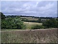
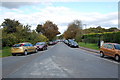
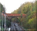
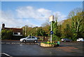
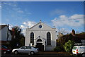
100 photos from this area
Area Information
Key information about the TN33 0DA including its size, population, and administrative classification.
- Area Type
- Postcode
- Area Size
- 8780 m²
- Population
- 1911
- Population Density
- 377 people/km²
House Prices in TN33 0DA
6
Properties
£297,238
Average Sold Price
£119,950
Lowest Price
£375,000
Highest Price
Showing 6 properties
| Address | Type | Beds | Baths | Last Sale Price | Last Sale Date | |
|---|---|---|---|---|---|---|
| Ivy Cottage, Battle Hill, Battle, TN33 0DA | Detached | 3 | 2 | £375,000 | Jun 2021 | |
| St Marys Farmhouse, Battle Hill, Battle, TN33 0DA | house | - | - | £326,500 | Mar 2021 | |
| Peppercorns, Battle Hill, Battle, TN33 0DA | Bungalow | - | - | £367,500 | May 2015 | |
| St Marys Farm Cottage, Battle Hill, Battle, TN33 0DA | Semi-detached | - | - | £119,950 | Sep 1999 | |
| Mandalay, Battle Hill, Battle, TN33 0DA | Detached | - | - | - | - | |
| Fawkes Lodge, Battle Hill, Battle, TN33 0DA | Detached | - | - | - | - |
Energy Efficiency in TN33 0DA
Amenities
Schools
| Rank | School | Type | Entry gender | Ages |
|---|
Explore more schools in this area
Go to Schools tabDemographics
Household Size
One person
most common
Accommodation Type
Houses
most common
Tenure
57
majority
Ethnic Group
White
most common
Religion
N/A
most common
Household Composition
N/A
most common
Age
47
median
Adults (30-64 years)
most common
Household Deprivation
N/A
with no deprivation
NS-SEC
31
in Lower managerial occupations
Explore more demographic insights in this area
Go to Demographics tabPlanning
Planning Constraints
- Flood RiskPremium
- Ramsar Wetland SitesPremium
- Area of Outstanding Natural BeautyPremium
- Protected Nature ReservePremium
- Protected WoodlandPremium