Area Overview for SP11 7JH
Photos of SP11 7JH


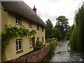
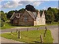
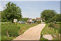

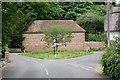

100 photos from this area
Area Information
Key information about the SP11 7JH including its size, population, and administrative classification.
- Area Type
- Postcode
- Area Size
- 21.1 hectares
- Population
- 2288
- Population Density
- 36 people/km²
House Prices in SP11 7JH
15
Properties
£430,000
Average Sold Price
£130,000
Lowest Price
£900,000
Highest Price
Showing 15 properties
| Address | Type | Beds | Baths | Last Sale Price | Last Sale Date | |
|---|---|---|---|---|---|---|
| 1, Kingsmill Barns, High Street, Wherwell, SP11 7JH | Semi-detached | 4 | 3 | £745,000 | Apr 2021 | |
| 2, Kingsmill Barns, High Street, Wherwell, SP11 7JH | Semi-detached | - | - | £590,000 | Aug 2015 | |
| Gavel House, Mill Lane, Wherwell, SP11 7JH | house | 5 | 3 | £900,000 | Oct 2013 | |
| Gavel Barn, High Street, Wherwell, SP11 7JH | house | - | - | £420,000 | Aug 2013 | |
| 1, Kingsmill Cottages, Winchester Road, Wherwell, SP11 7JH | Semi-detached | 4 | 1 | £380,000 | Nov 2006 | |
| 2, Kingsmill Cottages, Winchester Road, Wherwell, SP11 7JH | house | - | - | £140,000 | Mar 1997 | |
| 3, Kingsmill Cottages, Winchester Road, Wherwell, SP11 7JH | Terraced | - | - | £130,000 | Jan 1997 | |
| 4, Kingsmill Cottages, Winchester Road, Wherwell, SP11 7JH | Semi-detached | 4 | 2 | £135,000 | Dec 1996 | |
| Fishermans Lodge, Mill Lane, Wherwell, SP11 7JH | Semi-detached | 4 | - | - | - | |
| Tennis 126M From Little House, The Priory 25M From Unnamed Road, Mill Lane, Wherwell, SP11 7JH | Leisure | - | - | - | - |
Page 1 of 2
Energy Efficiency in SP11 7JH
Amenities
Schools
| Rank | School | Type | Entry gender | Ages |
|---|
Explore more schools in this area
Go to Schools tabDemographics
Household Size
Two person
most common
Accommodation Type
Houses
most common
Tenure
66
majority
Ethnic Group
White
most common
Religion
N/A
most common
Household Composition
N/A
most common
Age
47
median
Adults (30-64 years)
most common
Household Deprivation
N/A
with no deprivation
NS-SEC
44
in Lower managerial occupations
Explore more demographic insights in this area
Go to Demographics tabPlanning
Planning Constraints
- Flood RiskPremium
- Ramsar Wetland SitesPremium
- Area of Outstanding Natural BeautyPremium
- Protected Nature ReservePremium
- Protected WoodlandPremium