Area Overview for RG30 4JJ
Photos of RG30 4JJ


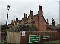
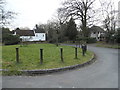
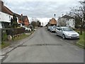

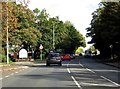


46 photos from this area
Area Information
Key information about the RG30 4JJ including its size, population, and administrative classification.
- Area Type
- Postcode
- Area Size
- 5.5 hectares
- Population
- 1537
- Population Density
- 1258 people/km²
House Prices in RG30 4JJ
10
Properties
£850,000
Average Sold Price
£525,000
Lowest Price
£1,295,000
Highest Price
Showing 10 properties
| Address | Type | Beds | Baths | Last Sale Price | Last Sale Date | |
|---|---|---|---|---|---|---|
| Oak Glade, New Lane Hill, Tilehurst, Reading, RG30 4JJ | Detached | 5 | 2 | £910,000 | Jun 2023 | |
| The Walled Garden, New Lane Hill, Tilehurst, Reading, RG30 4JJ | Detached | 4 | 3 | £920,000 | Jun 2021 | |
| The Manor House, New Lane Hill, Tilehurst, Reading, RG30 4JJ | house | - | - | £1,295,000 | Mar 2021 | |
| Lime Tree Cottage, New Lane Hill, Tilehurst, Reading, RG30 4JJ | house | 3 | - | £605,000 | Apr 2015 | |
| Rowan House, New Lane Hill, Tilehurst, Reading, RG30 4JJ | house | - | - | £875,000 | Jul 2012 | |
| Cambria Lodge, New Lane Hill, Tilehurst, Reading, RG30 4JJ | Detached | - | - | £825,000 | Aug 2006 | |
| Broomsgrove, New Lane Hill, Tilehurst, Reading, RG30 4JJ | Detached | - | - | £525,000 | Apr 2006 | |
| Charters, New Lane Hill, Tilehurst, Reading, RG30 4JJ | house | - | - | £845,000 | Apr 2004 | |
| Redroof Cottage, New Lane Hill, Tilehurst, Reading, RG30 4JJ | Retail | 3 | 2 | - | - | |
| The Annexe At, Charters, New Lane Hill, Tilehurst, Reading, RG30 4JJ | Detached | 3 | - | - | - |
Energy Efficiency in RG30 4JJ
Amenities
Schools
| Rank | School | Type | Entry gender | Ages |
|---|
Explore more schools in this area
Go to Schools tabDemographics
Household Size
Family (3-5 people)
most common
Accommodation Type
Houses
most common
Tenure
85
majority
Ethnic Group
White
most common
Religion
N/A
most common
Household Composition
N/A
most common
Age
47
median
Adults (30-64 years)
most common
Household Deprivation
N/A
with no deprivation
NS-SEC
44
in Lower managerial occupations
Explore more demographic insights in this area
Go to Demographics tabPlanning
Planning Constraints
- Flood RiskPremium
- Ramsar Wetland SitesPremium
- Area of Outstanding Natural BeautyPremium
- Protected Nature ReservePremium
- Protected WoodlandPremium