Area Overview for RG2 0NT
Photos of RG2 0NT

Area Information
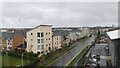
RG2 0NT is a compact residential cluster in England, covering just 9,509 square metres and home to 2,138 residents. Its high population density of 224,839 people per square kilometre reflects a tightly knit community where proximity to amenities is a defining feature. This area is not a sprawling suburb but a focused, small-scale neighbourhood with a strong local identity. Daily life here is shaped by its proximity to essential services, including multiple schools, retail outlets, and rail networks. The area’s small size means residents are likely to know their neighbours, with a mix of long-term residents and those drawn by the convenience of nearby infrastructure. While it lacks the sprawling green spaces of larger towns, its compact nature ensures minimal commute times to nearby hubs. The presence of primary schools and railway stations within practical reach makes RG2 0NT appealing for families and professionals seeking accessibility. However, its limited size also means housing stock is constrained, which could influence property availability and prices.
- Area Type
- Postcode
- Area Size
- 9509 m²
- Population
- 2138
- Population Density
- 4228 people/km²
The property market in RG2 0NT is characterised by a 37% home ownership rate, suggesting that the majority of housing is rented. This aligns with the area’s status as a small residential cluster, likely catering to commuters or those seeking proximity to nearby services. The accommodation type is primarily houses, which, given the area’s limited size, may mean properties are smaller or part of shared developments. This contrasts with larger urban areas where flats dominate, and it implies a more traditional housing stock. For buyers, the small footprint of RG2 0NT means the immediate surroundings are critical for property availability. The high population density, while not explicitly linked to property prices, may indicate limited space for expansion, potentially driving competition among buyers. Those considering the area should also factor in the need for proximity to transport and amenities, as the compact nature of RG2 0NT means housing is closely tied to its infrastructure.
House Prices in RG2 0NT
No properties found in this postcode.
Energy Efficiency in RG2 0NT
RG2 0NT offers a range of retail and transport amenities within easy reach. The area includes five retail outlets, such as Aldi Whitley, Morrisons Whitley, and Makro Reading, providing access to groceries, household goods, and general retail. These shops cater to daily needs, reducing the necessity for long trips to larger centres. The nearby railway stations—Reading West, Reading, and Earley—enhance connectivity, enabling quick travel to urban hubs for work, leisure, or shopping. While the data does not mention parks or leisure facilities, the presence of multiple retail and transport options suggests a practical, convenience-driven lifestyle. The compact nature of the area means amenities are closely clustered, supporting a walkable, accessible environment. However, the lack of specific details on green spaces or recreational facilities may be a consideration for those prioritising outdoor activities.
Amenities
Schools
Residents of RG2 0NT have access to three primary schools: Whitley Park Junior School, Whitley Park Infant and Nursery School, and Whitley Park Primary and Nursery School, which holds a ‘good’ Ofsted rating. This concentration of primary education options is a key asset for families with young children, offering multiple choices for early years and junior education. The presence of a school with a ‘good’ rating suggests at least one institution meets higher standards for teaching and facilities, though no secondary schools are listed in the data. The cluster of primary schools indicates the area is well-served for younger families, but those requiring secondary education may need to look beyond RG2 0NT. The proximity of these schools to homes in the area reinforces its appeal for families prioritising accessible education.
| Rank | School | Type | Entry gender | Ages |
|---|
Explore more schools in this area
Go to Schools tabDemographics
The community in RG2 0NT is predominantly composed of adults aged 30–64, with a median age of 47. This suggests a population skewed toward middle-aged individuals, possibly including professionals and families with children. Home ownership stands at 37%, indicating that a significant portion of the housing stock is rented, which may reflect the area’s role as a commuter zone or its appeal to those prioritising flexibility over long-term investment. The accommodation type is primarily houses, which, combined with the high population density, implies a mix of smaller homes and shared spaces. The predominant ethnic group is White, and while specific deprivation data is not provided, the demographic profile suggests a stable, established community. The age range and ownership figures hint at a population that may be less transient than younger, student-driven areas, though the exact implications for quality of life remain unquantified by the data.
Household Size
Accommodation Type
Tenure
Ethnic Group
Religion
Household Composition
Age
Household Deprivation
NS-SEC
Explore more demographic insights in this area
Go to Demographics tabPlanning
Planning Constraints
- Flood RiskPremium
- Ramsar Wetland SitesPremium
- Area of Outstanding Natural BeautyPremium
- Protected Nature ReservePremium
- Protected WoodlandPremium