Area Overview for OX7 3PT
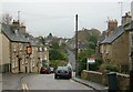
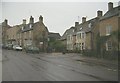
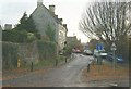
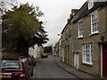
Photos of OX7 3PT


Area Information
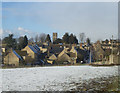
OX7 3PT is a specific postcode area covering a small residential cluster just under six hectares in size. You are looking at a tight-knit community of 1,176 people in the heart of the Cotswolds. This compact footprint creates a distinct neighbourhood feel where residents know their neighbours. The area functions as a quiet residential outpost rather than a bustling town centre. Daily life here revolves around access to nearby villages and the wider Oxfordshire countryside. The low population density of 130 people per square kilometre ensures space and relative tranquillity. You will find a predominantly residential zone that avoids the congestion of larger market towns. This makes it an attractive option for those seeking a settled rural experience without complete isolation. The postcode sits within a logical framework of existing infrastructure, serving as a bridge between larger settlements. Living in OX7 3PT offers a defined sense of place. You can rely on a consistent environment where the character remains stable over time. The area reflects a traditional settlement pattern suited to families and individuals who value space. Homes here provide a direct connection to the local landscape.
- Area Type
- Postcode
- Area Size
- 5.8 hectares
- Population
- 1176
- Population Density
- 130 people/km²
The property market in OX7 3PT is characterised by stability and a lack of high-volume rental turnover. With 74 per cent of properties owned outright or with a mortgage, the area functions as a strong owner-occupied zone. You will encounter primarily houses when viewing listings in this postcode cluster. This high level of home ownership implies that most vacancies are either inter-generational sales or rare instances where owners move up the property ladder. The market is not driven by transient students or corporate tenants. Buyers looking for detached or semi-detached homes will find a stock that matches the local demographic of established families. The concentration of houses reflects the rural nature of the 5.8 hectares that make up this residential space. Landlords have limited scope for expansion here, which often keeps competition low but supply tight. If you are searching for homes in OX7 3PT, expect a market where property values reflect long-term holding rather than speculative flipping. The high ownership percentage also means that maintenance is generally carried out by careful owners. This creates a consistent quality of housing stock. You do not need to worry about transient secondary market issues affecting the area's overall condition.
House Prices in OX7 3PT
Showing 19 properties
| Address | Type | Beds | Baths | Last Sale Price | Last Sale Date | |
|---|---|---|---|---|---|---|
| Holly House, Park Street, Charlbury, OX7 3PT | Detached | 3 | 2 | £650,000 | Apr 2024 | |
| China Cottage, Park Street, Charlbury, OX7 3PT | Cottage | 1 | 1 | £495,000 | Apr 2024 | |
| 1, Clarendon Court, Park Street, Charlbury, OX7 3PT | Terraced | 4 | - | £542,000 | Feb 2024 | |
| Priory Cottage, Park Street, Charlbury, OX7 3PT | Detached | 3 | 2 | £800,000 | Jan 2024 | |
| 3, Clarendon Court, Park Street, Charlbury, OX7 3PT | Terraced | - | - | £536,000 | Sep 2021 | |
| Parkwood View, Park Street, Charlbury, OX7 3PT | house | - | - | £827,300 | Sep 2021 | |
| Coach House, Park Street, Charlbury, OX7 3PT | Detached | - | - | £590,000 | Jun 2021 | |
| Wesley Cottage, Park Street, Charlbury, OX7 3PT | Cottage | 3 | 1 | £475,000 | Oct 2019 | |
| Rooken House, Park Street, Charlbury, OX7 3PT | house | - | - | £820,000 | Jul 2017 | |
| Rumford, Park Street, Charlbury, OX7 3PT | Detached | 3 | 2 | £545,000 | Sep 2014 |
Energy Efficiency in OX7 3PT
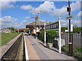
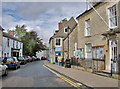
Your access to amenities in OX7 3PT is practical, focusing on essential retailers and transport links within reasonable distance. For your daily shopping needs, you are close to Co-op Charlbury and Co-op Long, which provide a wide range of household essentials. If you prefer a larger selection of groceries, Budgens Witney offers comprehensive retail options nearby. These five retail outlets in the immediate vicinity ensure you do not need to travel far for routine purchases. For travel, the area benefits from five railway stations within reach, including Charlbury Railway Station, Finstock Railway Station, and Ascott. These rail links connect you to larger towns and the main Oxford line network. This transport web allows you to commute to Oxford or London while retaining a rural address. The combination of local shops and rail access defines the character of living in this postcode. You have the convenience of village life with the connectivity of a regional hub. Walking distances to these amenities are short, preserving your time and energy. The layout supports a self-sufficient lifestyle where most daily transactions happen close to your home.
Amenities
Schools
| Rank | School | Type | Entry gender | Ages |
|---|
Explore more schools in this area
Go to Schools tabDemographics
The community in OX7 3PT is defined by a mature and established population. The median age sits at 47 years, indicating that the majority of residents fall into the 30 to 64 years age range. This profile suggests a family-oriented environment with significant numbers of adults raising children or nearing retirement. Home ownership stands at a high rate of 74 per cent, showing that the area is predominantly occupied by those who have already settled into the property market. You will find that most people here have purchased their homes rather than renting. The accommodation type is overwhelmingly houses, meaning terraced flats or high-rise living are uncommon in this specific cluster. The demographic skew towards adults reinforces the suitability for parents and grown-up families. Ethnic diversity appears limited, with White residents forming the predominant group. This homogeneity often contributes to a stable social fabric where local traditions persist. The absence of significant younger demographics or transient populations points to a deeply rooted community culture. For you, this means an established social network where people have lived for years. The data paints a clear picture of a neighbourhood built for long-term residents rather than short-term lettings.
Household Size
Accommodation Type
Tenure
Ethnic Group
Religion
Household Composition
Age
Household Deprivation
NS-SEC
Explore more demographic insights in this area
Go to Demographics tabPlanning
Planning Constraints
- Flood RiskPremium
- Ramsar Wetland SitesPremium
- Area of Outstanding Natural BeautyPremium
- Protected Nature ReservePremium
- Protected WoodlandPremium