Area Overview for OX4 1BU
Photos of OX4 1BU
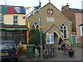
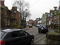
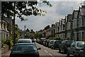
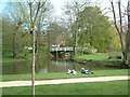
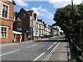
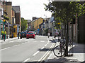
100 photos from this area
Area Information
Key information about the OX4 1BU including its size, population, and administrative classification.
- Area Type
- Postcode
- Area Size
- 9727 m²
- Population
- 1351
- Population Density
- 4058 people/km²
House Prices in OX4 1BU
65
Properties
£476,869
Average Sold Price
£40,000
Lowest Price
£970,000
Highest Price
Showing 65 properties
| Address | Type | Beds | Baths | Last Sale Price | Last Sale Date | |
|---|---|---|---|---|---|---|
| 16 Rectory Road, Oxford, OX4 1BU | house | 4 | 3 | £810,000 | Oct 2022 | |
| 50 Rectory Road, Oxford, OX4 1BU | Semi-detached | 4 | 1 | £864,500 | Apr 2019 | |
| 49 Rectory Road, Oxford, OX4 1BU | house | 4 | - | £970,000 | Nov 2018 | |
| 48 Rectory Road, Oxford, OX4 1BU | Semi-detached | 3 | 3 | £765,000 | Dec 2016 | |
| 37A Rectory Road, Oxford, OX4 1BU | Flat | 1 | 1 | £220,000 | Apr 2015 | |
| 25 Rectory Road, Oxford, OX4 1BU | Terraced | 4 | 2 | £670,101 | Feb 2014 | |
| 23 Rectory Road, Oxford, OX4 1BU | Terraced | 5 | 2 | £410,000 | Oct 2013 | |
| 18 Rectory Road, Oxford, OX4 1BU | Terraced | 2 | 1 | £390,000 | Sep 2013 | |
| 17 Rectory Road, Oxford, OX4 1BU | Terraced | 4 | 3 | £309,000 | Mar 2012 | |
| 15 Rectory Road, Oxford, OX4 1BU | Terraced | 4 | 3 | £465,000 | Feb 2010 |
Page 1 of 7
Energy Efficiency in OX4 1BU
Amenities
Schools
| Rank | School | Type | Entry gender | Ages |
|---|
Explore more schools in this area
Go to Schools tabDemographics
Household Size
Family (3-5 people)
most common
Accommodation Type
Houses
most common
Tenure
31
majority
Ethnic Group
White
most common
Religion
N/A
most common
Household Composition
N/A
most common
Age
22
median
Young Adults (15-29 years)
most common
Household Deprivation
N/A
with no deprivation
NS-SEC
34
in Lower managerial occupations
Explore more demographic insights in this area
Go to Demographics tabPlanning
Planning Constraints
- Flood RiskPremium
- Ramsar Wetland SitesPremium
- Area of Outstanding Natural BeautyPremium
- Protected Nature ReservePremium
- Protected WoodlandPremium