Area Overview for OX29 7PB
Photos of OX29 7PB
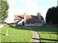
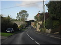
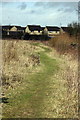
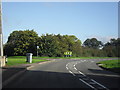


17 photos from this area
Area Information
Key information about the OX29 7PB including its size, population, and administrative classification.
- Area Type
- Postcode
- Area Size
- 4.1 hectares
- Population
- 2420
- Population Density
- 116 people/km²
House Prices in OX29 7PB
29
Properties
£352,141
Average Sold Price
£78,000
Lowest Price
£700,000
Highest Price
Showing 29 properties
| Address | Type | Beds | Baths | Last Sale Price | Last Sale Date | |
|---|---|---|---|---|---|---|
| 47 Well Lane, Curbridge, Witney, OX29 7PB | Bungalow | 3 | 1 | £495,000 | Aug 2025 | |
| 65 Well Lane, Curbridge, Witney, OX29 7PB | Bungalow | 2 | 1 | £285,000 | Aug 2025 | |
| 73 Well Lane, Curbridge, Witney, OX29 7PB | house | - | - | £695,000 | Apr 2024 | |
| 45 Well Lane, Curbridge, Witney, OX29 7PB | Retail | 3 | - | £318,000 | Jul 2022 | |
| 69 Well Lane, Curbridge, Witney, OX29 7PB | Bungalow | 3 | 2 | £460,000 | Sep 2021 | |
| 63 Well Lane, Curbridge, Witney, OX29 7PB | Bungalow | 2 | 1 | £370,000 | Jun 2021 | |
| 71 Well Lane, Curbridge, Witney, OX29 7PB | house | - | - | £675,000 | Aug 2018 | |
| 75 Well Lane, Curbridge, Witney, OX29 7PB | house | - | - | £700,000 | Jul 2018 | |
| 67 Well Lane, Curbridge, Witney, OX29 7PB | Bungalow | 2 | 1 | £340,000 | Jun 2018 | |
| Brook Cottage, 1B Well Lane, Curbridge, Witney, OX29 7PB | Cottage | 3 | - | £353,000 | Sep 2015 |
Page 1 of 3
Energy Efficiency in OX29 7PB
Amenities
Schools
| Rank | School | Type | Entry gender | Ages |
|---|
Explore more schools in this area
Go to Schools tabDemographics
Household Size
Two person
most common
Accommodation Type
Houses
most common
Tenure
74
majority
Ethnic Group
White
most common
Religion
N/A
most common
Household Composition
N/A
most common
Age
47
median
Adults (30-64 years)
most common
Household Deprivation
N/A
with no deprivation
NS-SEC
39
in Lower managerial occupations
Explore more demographic insights in this area
Go to Demographics tabPlanning
Planning Constraints
- Flood RiskPremium
- Ramsar Wetland SitesPremium
- Area of Outstanding Natural BeautyPremium
- Protected Nature ReservePremium
- Protected WoodlandPremium