Area Overview for OX25 5PA
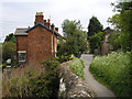
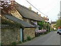
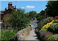
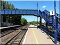
Photos of OX25 5PA


Area Information
OX25 5PA is a compact residential cluster covering just under 4,800 square metres. This small footprint supports a population of 1,482 residents, creating a close-knit community where neighbours inevitably interact. The area sits within the White capacity of Oxfordshire, offering a settled environment rather than a rapidly changing development site. You will find that daily life here is defined by its size and density, which stand at 145 people per square kilometre. This density ensures public services and local amenities remain accessible without the congestion found in larger urban villages. Living in OX25 5PA means experiencing a neighbourhood where the built environment surrounds you but does not overwhelm it. The layout prioritises residential function over commercial expansion, maintaining a distinct separation between home and work. This specific postcode area provides a stable backdrop for families and individuals seeking a defined home territory away from the sprawl of larger towns. Your immediate surroundings offer a clear sense of place, characterised by its modest scale and concentrated population.
- Area Type
- Postcode
- Area Size
- 4788 m²
- Population
- 1482
- Population Density
- 145 people/km²
The property market in OX25 5PA reflects a clear owner-occupied bias, with 73% of the housing stock held by owners. Houses are the primary accommodation type, meaning you will rarely find purpose-built flats or city-style apartments available for purchase. This ownership structure indicates that landlords operating buy-to-let schemes are a minority compared to resident families. The small area size of 4,788 square metres limits the volume of new builds, reinforcing the existing stock as the main source of supply. Buyers looking at homes in OX25 5PA are joining an established market where properties have often been in the same hands for generations. The high home ownership rate of 73% means that rental demand exists but competes with the resale market for efficient housing solutions. Your search for properties here will focus on detached or semi-detached houses rather than converted warehouses or apartments. This market composition offers stability but requires patience, as estate agents may list fewer units than in high-growth rental districts. The nature of the housing stock aligns with the local demographic's preference for space and privacy.
House Prices in OX25 5PA
Showing 4 properties
| Address | Type | Beds | Baths | Last Sale Price | Last Sale Date | |
|---|---|---|---|---|---|---|
| 16 The Lane, Lower Heyford, OX25 5PA | Land | - | - | £585,000 | Feb 2021 | |
| Garden Cottage, The Lane, Lower Heyford, OX25 5PA | Detached | 4 | - | £575,000 | Dec 2013 | |
| Merrys Farmhouse, 6 The Lane, Lower Heyford, OX25 5PA | Detached | - | - | £425,000 | Dec 2001 | |
| Caravan, Garden Cottage, The Lane, Lower Heyford, OX25 5PA | Mobile Home | - | - | - | - |
Energy Efficiency in OX25 5PA
Your daily lifestyle in OX25 5PA benefits from a practical network of nearby amenities within easy reach. Two railway stations, Heyford and Tackley, provide rail access for your daily commute without requiring a long walk. Five retail outlets ensure you have a comprehensive range of shops nearby. You can routinely visit Sainsburys Upper Heyford for groceries or head to Co-op Bletchingdon and Co-op Deddington for additional needs. Two airports, Oxford Kidlington and London Oxford Airport, are within practical reach, offering direct flight options for business or leisure. This proximity to major transport hubs means you do not need to travel far for essential services or international connections. The availability of supermarkets and cooperatives guarantees access to fresh food and everyday items without leaving the immediate vicinity. Dining options may be limited to local takeaways or small eateries, but the major retailers cover most staple requirements. You will appreciate the convenience of having Sainsburys Upper Heyford only minutes away for quick shopping runs.
Amenities
Schools
| Rank | School | Type | Entry gender | Ages |
|---|
Explore more schools in this area
Go to Schools tabDemographics
The community profile in OX25 5PA is dominated by adults, with the most common age range falling between 30 and 64 years. This mature demographic indicates a settled population rather than a transient area filled with young professionals or retirees. The median age stands at 47, confirming that households consist largely of established families or individuals with long-term commitments. Home ownership is the norm, with 73% of residents owning their properties outright or with a mortgage. This high ownership rate suggests stability, as owners are less likely to move frequently compared to tenants. Houses form the predominant accommodation type, reflecting a preference for land and garden space over high-density living. The predominant ethnic group is White, mirroring the broader demographic trends of the surrounding English countryside. You will encounter a demographic landscape that values permanence and family integration over rapid turnover. This steady age profile and high ownership percentage create a predictable social environment where community ties tend to remain strong over extended periods.
Household Size
Accommodation Type
Tenure
Ethnic Group
Religion
Household Composition
Age
Household Deprivation
NS-SEC
Explore more demographic insights in this area
Go to Demographics tabPlanning
Planning Constraints
- Flood RiskPremium
- Ramsar Wetland SitesPremium
- Area of Outstanding Natural BeautyPremium
- Protected Nature ReservePremium
- Protected WoodlandPremium