Area Overview for OX18 4SQ
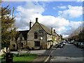
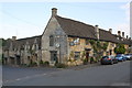
Photos of OX18 4SQ


Area Information
OX18 4SQ defines a specific residential cluster within England, covering an area of just 3.1 hectares. This compact footprint supports a population of 1,977 residents, creating a dense yet manageable neighbourhood experience. You are purchasing into a concentrated environment where daily life revolves around the immediate surroundings rather than travel to distant hubs. The area functions as a self-contained community where proximity defines convenience. Living here means navigating a small landscape where neighbours are likely to know one another quickly. The geography limits sprawl, fostering an atmosphere where the built environment dominates the natural setting. This postcode is not a sprawling town but a defined pocket of housing where the scale of development is consistent. You will experience a community where access to local services is a matter of short walks rather than car journeys. The small size ensures that noise and activity remain focused, avoiding the chaotic spread found in larger urban zones. Your daily routine in OX18 4SQ will be shaped by this efficiency, with everything required for daily living located at hand.
- Area Type
- Postcode
- Area Size
- 3.1 hectares
- Population
- 1977
- Population Density
- 73 people/km²
The property market in OX18 4SQ is characterised by a strong owner-occupier bias. With 65% of homes owned outright or with a mortgage, this postcode operates more as a retirement or family buy-to-stay zone than a transient rental hub. Houses dominate the housing stock, meaning you will search for detached or semi-detached properties rather than apartments or flats. This mix suits buyers seeking traditional gardens and private outdoor space over shared facilities. The small size of the postcode area limits the volume of listings, making each available property significantly more competitive. Buyers looking at homes in OX18 4SQ should anticipate a market where inventory is scarce but demand is steady. The presence of protected woodland nearby may influence the type of development permitted in the immediate vicinity, potentially limiting new builds. Current trends suggest a focus on established properties that require little renovation beyond cosmetic updates. If you are a first-time buyer, the low population density and high ownership rate might indicate limited entry-level stock. However, the stability of the area supports long-term value retention for those purchasing now.
House Prices in OX18 4SQ
Showing 2 properties
| Address | Type | Beds | Baths | Last Sale Price | Last Sale Date | |
|---|---|---|---|---|---|---|
| Tennis 109M From Direct Fleet Insurance, The Old Brewery, Priory Lane 92M From Priory Lane, Priory Lane, Burford, OX18 4SQ | Leisure | - | - | - | - | |
| Priory Of Our Lady, 30 Priory Lane, Burford, OX18 4SQ | Detached | - | - | - | - |
Energy Efficiency in OX18 4SQ
Your daily life in OX18 4SQ is supported by a practical network of nearby amenities within easy reach. Retail options include Co-op Burford, Co-op Centrum, and Co-op Brize, offering essential shopping needs without the need to travel far. For those requiring rail links, Shipton Railway Station and Ascott station provide two rail connections close to the postcode. Travelers can also access RAF Brize Norton airport, which serves as a notable air transport hub within the vicinity. These amenities create a convenient lifestyle where daily errands and occasional business travel are manageable by car. The presence of retail chains suggests established commercial areas that cater to local residents rather than purely tourist traffic. You will find familiar supermarket brands and convenience stores nearby for spontaneous purchases. The rail stations offer connectivity to wider towns if you need weekender trips or business connections. While specific dining and leisure venues are not listed in the immediate data, the presence of major retail and transport hubs ensures basic lifestyle needs are fully met. Living in OX18 4SQ balances quiet residential living with accessible services.
Amenities
Schools
Families residing in OX18 4SQ are served by a network of educational institutions with generally high standards. Burford Primary School operates as a primary school and holds a good Ofsted rating. Burford School and Community College also functions as a primary school within the local catchment. For secondary education, Burford School serves as an academy with a good Ofsted rating, providing comprehensive education for older children. The presence of multiple schools with good ratings indicates a robust educational framework. The mix of academy and community running schools offers variety in curriculum and ethos without compromising on quality. Residents benefit from having options accessible from the area, reducing the need for long commutes to distant institutions. The good ratings across the board suggest that academic outcomes are a priority for the local education system. Parents considering schools near OX18 4SQ will find a selection of reputable institutions that maintain consistent standards. These schools integrate pupils from the immediate neighbourhood, fostering a strong link between education and community.
| Rank | School | Type | Entry gender | Ages |
|---|
Explore more schools in this area
Go to Schools tabDemographics
The community in OX18 4SQ reflects a mature demographic profile, with a median age of 47 years. Adults between the ages of 30 and 64 years form the most common age range, indicating a stable population structure. Home ownership stands at 65%, suggesting that the majority of households have secured their property titles rather than renting. Houses are the predominant accommodation type, meaning you will find single-family dwellings rather than flats or terraced blocks in this specific cluster. The area is predominantly White ethnically, contributing to a cohesive community character. These statistics indicate an area established by families and established professionals rather than transient populations. A two-thirds home ownership rate implies strong local investment and a lack of high tenant turnover. You can expect a neighbourly environment where residents are likely long-term occupants. The absence of young families as the primary demographic means the area may lack the noise of early childhood but offers stability. Living in OX18 4SQ aligns with the lifestyle of those who value quiet, established communities over vibrant, youthful energy.
Household Size
Accommodation Type
Tenure
Ethnic Group
Religion
Household Composition
Age
Household Deprivation
NS-SEC
Explore more demographic insights in this area
Go to Demographics tabPlanning
Planning Constraints
- Flood RiskPremium
- Ramsar Wetland SitesPremium
- Area of Outstanding Natural BeautyPremium
- Protected Nature ReservePremium
- Protected WoodlandPremium