Area Overview for OX10 8BH
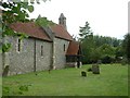
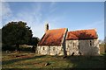
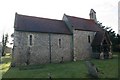
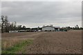
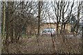
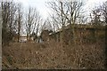
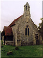
Photos of OX10 8BH


Area Information
OX10 8BH is a specific postcode covering a small residential cluster of 11.5 hectares in Oxfordshire. With a population of 1026 people, this area maintains a density of 476 people per square kilometre. The scale suggests a close-knit environment where neighbours are likely to know one another. Residents experience a quiet daily rhythm typical of rural Oxfordshire, situated well away from the urban grind of central Oxford. The geography creates a contained living space that feels intimate yet offers access to wider networks. Families and individuals seeking a alternative to density will find the residential layout natural and appealing.
- Area Type
- Postcode
- Area Size
- 11.5 hectares
- Population
- 1026
- Population Density
- 476 people/km²
The housing stock in OX10 8BH is overwhelmingly owner-occupied, with 79% of dwellings in this postcode belonging to their current residents. This high ownership rate defines the local market as a place for settlement rather than speculation. The predominant accommodation type is Houses, meaning you will find fewer flats or terraced properties compared to urban areas. This housing characteristic supports the mature demographic and offers privacy and space that appeals to families or working professionals seeking a garden. Because nearly four out of every five homes are owner-occupied, the area likely has a stable inventory and lower rental turnover. If you are looking to purchase, competition here comes from established buyers who value permanence. The focus on Houses ensures that buyers trade in properties with land and space, fitting the description of traditional Oxfordshire living.
House Prices in OX10 8BH
Showing 4 properties
| Address | Type | Beds | Baths | Last Sale Price | Last Sale Date | |
|---|---|---|---|---|---|---|
| 7 Meadow Lane, Crowmarsh Gifford, Wallingford, OX10 8BH | Detached | 4 | 2 | £615,000 | Jan 2021 | |
| 5 Meadow Lane, Crowmarsh Gifford, Wallingford, OX10 8BH | house | 4 | - | £467,000 | Oct 2011 | |
| 9 Meadow Lane, Crowmarsh Gifford, Wallingford, OX10 8BH | house | - | - | £427,000 | Jan 2005 | |
| Meadow Cottage, Meadow Lane, Crowmarsh Gifford, Wallingford, OX10 8BH | Detached | - | - | £290,000 | Dec 2001 |
Energy Efficiency in OX10 8BH
Your daily conveniences lie just a short drive away in the wider Oxfordshire countryside. Residents have access to five key retail locations within practical reach. You can shop at the Waitrose in Wallingford, the Asda in Rectory, or the Lidl on Lupton Road for everyday groceries and household items. For larger shopping trips, the town of Wallingford provides metro facilities plus pubs, cafes, and leisure venues. The area also benefits from proximity to two airports: RAF Benson and Chalgrove Airport, which is useful for aviation enthusiasts or local business flights. Rail connections are equally accessible, with Cholsey Railway Station, Goring and Streatley Railway Station, and Didcot Parkway Railway Station all nearby. This connectivity allows you to reach major employment hubs in Oxford or London efficiently. The blend of rural peace and accessible transport makes OX10 8BH convenient for active living.
Amenities
Schools
Homebuyers typically prioritise education when choosing where to live in OX10 8BH. The nearest school is Crowmarsh Gifford Church of England School, which operates as a primary institution. This school carries a Good rating from Ofsted, a standard that meets government expectations for quality education. The presence of a primary school indicates that residents have local access to education for younger children without needing to travel to distant towns like Wallingford for elementary education. This single primary option suggests a balanced mix for families with young children, though parents of secondary-aged students will need to look further afield. The rating provides confidence that the local educational provision meets rigorous standards. Families in OX10 8BH benefit from this reputable local asset when planning their household needs.
| Rank | School | Type | Entry gender | Ages |
|---|
Explore more schools in this area
Go to Schools tabDemographics
The community in OX10 8BH is defined by a mature and stable resident base. The median age sits at 47 years, confirming that Adults between the ages of 30 and 64 constitute the most common age range. This demographic profile indicates a neighbourhood populated by established families and commuters rather than millennial renters. Home ownership stands at an impressive 79% for OX10 8BH, demonstrating strong local roots and financial stability among residents. The predominant ethnic group is White, reflecting the broader demographics of Oxfordshire. The area accommodates primarily Houses, which aligns with the preference of the older demographic for detached or semi-detached living arrangements. This ownership structure means you can expect a settled community where long-term residents have shaped the local character over many years.
Household Size
Accommodation Type
Tenure
Ethnic Group
Religion
Household Composition
Age
Household Deprivation
NS-SEC
Explore more demographic insights in this area
Go to Demographics tabPlanning
Planning Constraints
- Flood RiskPremium
- Ramsar Wetland SitesPremium
- Area of Outstanding Natural BeautyPremium
- Protected Nature ReservePremium
- Protected WoodlandPremium