Area Overview for ME15 9YN
Photos of ME15 9YN


Area Information
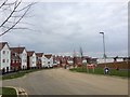
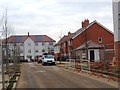
ME15 9YN is a small, tightly packed residential postcode area in England, covering just 7,477 square metres. With a population of 1,612 people, it is densely populated, translating to 215,583 people per square kilometre. This compact cluster of homes is ideal for those seeking a close-knit community with easy access to essential services. Daily life here is shaped by its proximity to retail outlets, rail networks, and a well-regarded local school. The area’s small size means residents are likely to know their neighbours, fostering a sense of familiarity. While the median age is 22, the majority of residents are adults aged 30–64, suggesting a mix of long-term residents and families. The high home ownership rate of 76% indicates a stable, settled population, with most properties being houses rather than flats. For buyers, ME15 9YN offers a blend of practicality and community, though its limited size means choices for housing are constrained. The area’s appeal lies in its accessibility to nearby amenities, making it a viable option for those prioritising convenience over expansive space.
- Area Type
- Postcode
- Area Size
- 7477 m²
- Population
- 1612
- Population Density
- 1765 people/km²
ME15 9YN is primarily an owner-occupied area, with 76% of homes owned by residents rather than rented. The accommodation type is predominantly houses, which is unusual for a small postcode area but may reflect the community’s preference for family-friendly housing. This suggests a market where properties are likely to be long-term investments rather than short-term rentals. The limited size of the area means the housing stock is constrained, reducing the number of available options for buyers. Those seeking a home here may find a focus on single-family homes, which could be appealing for families but less so for those requiring flats or shared spaces. The high home ownership rate also indicates a stable market, with fewer turnover rates. However, the small size of ME15 9YN means buyers should consider nearby areas for additional options, as the immediate vicinity may have limited choices.
House Prices in ME15 9YN
Showing 1 properties
| Address | Type | Beds | Baths | Last Sale Price | Last Sale Date | |
|---|---|---|---|---|---|---|
| Dutton Forshaw Skoda, Bircholt Road, Maidstone, ME15 9YN | warehouse | - | - | - | - |
Energy Efficiency in ME15 9YN
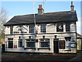
Residents of ME15 9YN have access to a range of nearby amenities within practical reach. The retail sector includes notable stores such as Aldi Langley, Morrisons Daily, and Co-op Maidstone, providing everyday shopping options. These outlets cater to household needs, from groceries to household goods. The rail network is well-served by stations like Bearsted, Maidstone West, and Hollingbourne, offering connections to broader transport routes. While the data does not specify parks or leisure facilities, the proximity to retail and rail suggests a lifestyle focused on convenience and accessibility. The area’s compact nature means amenities are closely clustered, reducing travel time for daily errands. For those valuing ease of access to shopping and transport, ME15 9YN offers a practical setup, though additional recreational options may require venturing slightly further afield.
Amenities
Schools
The nearest school to ME15 9YN is Leigh Academy Langley Park, an academy with an Ofsted rating of ‘good’. This institution serves the local community, offering education to students in the area. As the only named school in the data, it is the primary option for families in ME15 9YN. The absence of other schools suggests a reliance on this single establishment, which may be a consideration for parents seeking multiple schooling options. The ‘good’ rating indicates a satisfactory standard of education, though no further details on curriculum or performance are provided. Families prioritising schooling may need to evaluate whether Leigh Academy Langley Park meets their specific needs, particularly if they require additional facilities or alternative educational approaches.
| Rank | School | Type | Entry gender | Ages |
|---|
Explore more schools in this area
Go to Schools tabDemographics
The community in ME15 9YN is predominantly composed of adults aged 30–64, despite a median age of 22. This suggests a mix of younger residents and families with older dependents. Home ownership is high at 76%, with most properties being houses, reflecting a stable, long-term demographic. The predominant ethnic group is White, though no specific data on diversity or deprivation is available. The population density of 215,583 people per square kilometre indicates a compact, possibly urbanised environment. This density may influence daily life, with limited green space but strong connectivity to retail and transport. The age profile suggests a balance between working-age adults and those in later life, which could shape local services and amenities. However, the data does not provide insight into socioeconomic factors beyond ownership rates. The area’s small size and high population density mean residents are likely to share similar needs, from schooling to shopping.
Household Size
Accommodation Type
Tenure
Ethnic Group
Religion
Household Composition
Age
Household Deprivation
NS-SEC
Explore more demographic insights in this area
Go to Demographics tabPlanning
Planning Constraints
- Flood RiskPremium
- Ramsar Wetland SitesPremium
- Area of Outstanding Natural BeautyPremium
- Protected Nature ReservePremium
- Protected WoodlandPremium