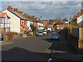
Area Overview for GU12 4PY
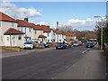
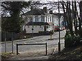
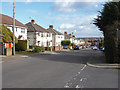
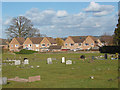
Photos of GU12 4PY


Area Information
Living in GU12 4PY offers a compact, residential experience defined by its small cluster of homes and high population density. Covering 8,233 square metres, this postcode area is home to 1,586 residents, creating a tightly knit community. The area’s size and population suggest a focused, localised environment where amenities and services are within close reach. With a median age of 47 and a majority of residents aged 30–64, the neighbourhood leans towards adults, many of whom are likely long-term residents. The high home ownership rate of 76% and prevalence of houses indicate a stable, family-oriented demographic. Daily life here is shaped by proximity to key services, including primary schools and rail links, while the area’s low crime risk and absence of environmental constraints like protected woodlands or AONB status suggest a practical, low-stress living environment. For buyers, GU12 4PY represents a blend of accessibility and quiet living, with its small footprint ensuring a sense of familiarity and community cohesion.
- Area Type
- Postcode
- Area Size
- 8233 m²
- Population
- 1586
- Population Density
- 5353 people/km²
GU12 4PY is a predominantly owner-occupied area, with 76% of residents owning their homes. The accommodation type is overwhelmingly houses, which is significant for a small postcode cluster. This suggests a housing stock that prioritises private, standalone properties over flats or shared spaces, catering to families or individuals seeking stability. The high home ownership rate indicates a market where property is likely to be held long-term, reducing turnover and fostering a sense of permanence. For buyers, this means a limited but focused selection of homes, with potential for investment in a stable, low-risk market. The absence of rental properties also means the area is less influenced by transient populations, reinforcing its character as a settled community. Given the small size of the area, buyers should consider proximity to surrounding regions for broader property options, though GU12 4PY itself offers a compact, family-friendly environment.
House Prices in GU12 4PY
Showing 31 properties
| Address | Type | Beds | Baths | Last Sale Price | Last Sale Date | |
|---|---|---|---|---|---|---|
| 137 Newport Road, Aldershot, GU12 4PY | Terraced | 2 | 2 | £355,000 | Mar 2025 | |
| 141 Newport Road, Aldershot, GU12 4PY | Terraced | 3 | 1 | £306,000 | Feb 2025 | |
| 120 Newport Road, Aldershot, GU12 4PY | Terraced | 3 | 1 | £335,000 | Oct 2024 | |
| 139 Newport Road, Aldershot, GU12 4PY | Terraced | 2 | 2 | £385,000 | Dec 2022 | |
| 149 Newport Road, Aldershot, GU12 4PY | Semi-detached | 3 | 1 | £385,000 | Nov 2022 | |
| 118A Newport Road, Aldershot, GU12 4PY | Retail | 3 | 2 | £440,000 | Aug 2022 | |
| 126 Newport Road, Aldershot, GU12 4PY | house | 3 | 1 | £375,000 | May 2022 | |
| 110 Newport Road, Aldershot, GU12 4PY | house | - | - | £342,000 | Jun 2021 | |
| 128 Newport Road, Aldershot, GU12 4PY | house | - | - | £295,000 | Mar 2021 | |
| 130 Newport Road, Aldershot, GU12 4PY | Terraced | 3 | 2 | £317,000 | Mar 2021 |
Energy Efficiency in GU12 4PY
Residents of GU12 4PY have access to a range of local amenities, including five retail outlets such as Sainsburys Aldershot and The Southern Co-operative. These shops provide essential services, from groceries to general retail, reducing the need for long trips. The rail network, with stations like Aldershot and Ash Vale, connects the area to broader regional hubs, enhancing accessibility. While the data does not mention parks or leisure facilities, the proximity to rail and retail suggests a lifestyle balanced between convenience and practicality. The absence of detailed information on parks or dining options means buyers should explore the immediate vicinity for recreational opportunities. Overall, the area’s amenities support a self-contained lifestyle, with local shopping and transport options complementing the compact residential environment.
Amenities
Schools
Residents of GU12 4PY have access to three primary schools within practical reach: Newport Junior School, Newport County Junior School, and Newport County Infant School. These institutions cater to early years and primary education, providing a range of options for families. The presence of three primary schools suggests a focus on local education, with no secondary schools listed in the data. This could mean that students may need to travel to nearby areas for secondary education, though the proximity of rail links might ease this transition. For families prioritising school proximity, the availability of multiple primary schools is a key advantage, ensuring choices in terms of school size, teaching methods, or community alignment. However, the lack of secondary school data means buyers should investigate further if secondary education is a priority.
| Rank | School | Type | Entry gender | Ages |
|---|
Explore more schools in this area
Go to Schools tabDemographics
GU12 4PY’s population of 1,586 people is spread across 8,233 square metres, resulting in a density of 192,637 people per square kilometre. This reflects a highly concentrated residential area, typical of smaller postcode clusters. The median age of 47 and a dominant age group of 30–64 years suggest a mature, established community with a strong presence of middle-aged adults. Home ownership is high at 76%, indicating a stable housing market with fewer rental properties. The area is predominantly occupied by White residents, though no specific data on diversity or deprivation is provided. The absence of detailed diversity metrics means the community profile remains focused on this primary demographic. For buyers, this suggests a neighbourhood where long-term residents are likely to remain, with housing stock tailored to family or multi-generational needs. The low population density relative to the area’s size implies a mix of single-family homes and smaller properties, supporting a lifestyle prioritising privacy and local connections.
Household Size
Accommodation Type
Tenure
Ethnic Group
Religion
Household Composition
Age
Household Deprivation
NS-SEC
Explore more demographic insights in this area
Go to Demographics tabPlanning
Planning Constraints
- Flood RiskPremium
- Ramsar Wetland SitesPremium
- Area of Outstanding Natural BeautyPremium
- Protected Nature ReservePremium
- Protected WoodlandPremium