Area Overview for GU12 4EA
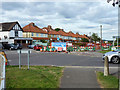
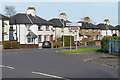
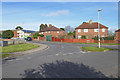
Photos of GU12 4EA


Area Information
GU12 4EA is a compact residential postcode in England, covering just 1.0 hectares and home to 1,575 people. Its high population density of 151,571 people per square kilometre reflects a tightly knit community, though the area remains small enough to feel intimate. The postcode forms part of a broader cluster of homes, predominantly owner-occupied houses, which suggests a stable, long-term resident base. With a median age of 47 and a majority of adults aged 30–64, the area is characterised by a mature population, likely with established careers and families. Daily life here is shaped by proximity to key infrastructure: Aldershot’s rail network, retail hubs like Sainsburys, and Farnborough Airport. The low flood risk and absence of protected natural sites mean residents face minimal environmental constraints, while the area’s safety score of 67/100 indicates a generally secure environment. For buyers, GU12 4EA offers a blend of practicality and accessibility, with homes that cater to those prioritising convenience and connectivity over sprawling landscapes.
- Area Type
- Postcode
- Area Size
- 1.0 hectares
- Population
- 1575
- Population Density
- 7687 people/km²
GU12 4EA is primarily an owner-occupied area, with 79% of homes owned by residents rather than rented. The accommodation type is predominantly houses, indicating a focus on family-friendly, standalone properties rather than apartments or terraced housing. This suggests a housing stock tailored to long-term residents, with limited turnover and a strong sense of community. The small area size—just 1.0 hectare—means the market is unlikely to expand significantly, making it a niche market for buyers seeking established homes. The high home ownership rate also implies that rental options are limited, potentially reducing competition for landlords. For buyers, this means properties are likely to be well-maintained and reflect the needs of a mature demographic. However, the compact nature of the area means proximity to amenities is critical, with residents relying on nearby towns for broader retail and leisure options.
House Prices in GU12 4EA
Showing 34 properties
| Address | Type | Beds | Baths | Last Sale Price | Last Sale Date | |
|---|---|---|---|---|---|---|
| 52 Lower Farnham Road, Aldershot, GU12 4EA | Detached | 4 | 2 | £490,500 | Sep 2025 | |
| 10 Lower Farnham Road, Aldershot, GU12 4EA | Terraced | 3 | 1 | £325,000 | Apr 2024 | |
| 30 Lower Farnham Road, Aldershot, GU12 4EA | Semi-detached | 3 | 1 | £280,000 | Sep 2021 | |
| 38 Lower Farnham Road, Aldershot, GU12 4EA | Terraced | 2 | 1 | £260,000 | Sep 2021 | |
| 60 Lower Farnham Road, Aldershot, GU12 4EA | Terraced | 2 | 1 | £245,000 | Jun 2021 | |
| 56 Lower Farnham Road, Aldershot, GU12 4EA | Semi-detached | 4 | 1 | £400,000 | Nov 2020 | |
| 44 Lower Farnham Road, Aldershot, GU12 4EA | Semi-detached | 3 | 1 | £220,000 | Feb 2020 | |
| 12 Lower Farnham Road, Aldershot, GU12 4EA | Terraced | 2 | 2 | £249,000 | Feb 2020 | |
| 36 Lower Farnham Road, Aldershot, GU12 4EA | Terraced | 2 | 1 | £190,000 | Jul 2019 | |
| 24 Lower Farnham Road, Aldershot, GU12 4EA | Semi-detached | 2 | 2 | £230,000 | Mar 2019 |
Energy Efficiency in GU12 4EA
The lifestyle in GU12 4EA is shaped by its proximity to essential amenities. Retail options include Sainsburys Aldershot and The Southern Co-operative Co, ensuring residents have access to everyday shopping needs. The area’s rail connections—Aldershot, Ash, and Ash Vale stations—provide straightforward access to nearby towns and cities, while Farnborough Airport offers regional travel options. Though the postcode itself is small, the surrounding area offers a mix of practicality and convenience, with shops, transport links, and the potential for commuting to larger centres. The lack of extensive leisure or recreational facilities within the postcode means residents may rely on nearby towns for parks, dining, and cultural activities. However, the density of retail and transport options suggests a lifestyle focused on efficiency and accessibility rather than expansive leisure opportunities.
Amenities
Schools
| Rank | School | Type | Entry gender | Ages |
|---|
Explore more schools in this area
Go to Schools tabDemographics
The population of GU12 4EA is predominantly adults aged 30–64, with a median age of 47. This suggests a community of established professionals and families, rather than students or retirees. Home ownership is high at 79%, with the majority of properties being houses rather than flats. The predominant ethnic group is White, reflecting a homogenous demographic profile. The absence of specific data on deprivation means this aspect of quality of life remains unquantified, but the high home ownership rate and mature age range imply a stable, low-turnover community. With no significant minority groups noted, the area’s social fabric is likely shaped by shared cultural norms and local traditions. The density of 151,571 people per square kilometre, while high, is manageable within the small footprint of the postcode, suggesting a balance between urban convenience and residential comfort.
Household Size
Accommodation Type
Tenure
Ethnic Group
Religion
Household Composition
Age
Household Deprivation
NS-SEC
Explore more demographic insights in this area
Go to Demographics tabPlanning
Planning Constraints
- Flood RiskPremium
- Ramsar Wetland SitesPremium
- Area of Outstanding Natural BeautyPremium
- Protected Nature ReservePremium
- Protected WoodlandPremium