Area Overview for GU11 4AW
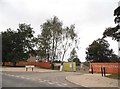
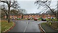
Photos of GU11 4AW


Area Information
GU11 4AW is a compact residential postcode area in England, covering just 1.2 hectares and home to 2,218 residents. Its high population density — 178,130 people per square kilometre — reflects a tightly knit community, though the area remains small enough to feel intimate. The postcode sits in a cluster of homes, likely centred around local amenities and transport links. With a median age of 47, the area is predominantly populated by adults aged 30–64, suggesting a stable, mature demographic. Daily life here is likely shaped by proximity to schools, retail, and rail networks, with a mix of domestic and local employment opportunities. The area’s small size means it is easy to navigate on foot or by bike, and its infrastructure appears well-serviced, given the excellent broadband connectivity and nearby rail stations. While the population is relatively small, the density implies a lively, interconnected neighbourhood where community ties may be strong.
- Area Type
- Postcode
- Area Size
- 1.2 hectares
- Population
- 2218
- Population Density
- 2353 people/km²
The property market in GU11 4AW is characterised by a 45% home ownership rate, meaning nearly half of residents rent their homes. This suggests a balance between owner-occupied and rental properties, though the exact proportion of the latter is unclear. The area is primarily composed of houses, not flats, which may indicate a preference for family-friendly or semi-detached housing. Given the small size of the postcode — just 1.2 hectares — the housing stock is likely limited, with properties concentrated in a small cluster. Buyers should consider that the area’s compact nature may restrict availability, and proximity to amenities like schools and rail links could drive demand. For those seeking a home, the focus would likely be on established properties rather than new developments.
House Prices in GU11 4AW
Showing 22 properties
| Address | Type | Beds | Baths | Last Sale Price | Last Sale Date | |
|---|---|---|---|---|---|---|
| 25 Hospital Road, Wellesley, Aldershot, GU11 4AW | Semi-detached | 3 | 2 | £415,000 | Jul 2025 | |
| 3 Hospital Road, Wellesley, Aldershot, GU11 4AW | house | - | - | £585,000 | May 2025 | |
| 27 Hospital Road, Wellesley, Aldershot, GU11 4AW | Semi-detached | 3 | 2 | £410,000 | May 2025 | |
| 23 Hospital Road, Wellesley, Aldershot, GU11 4AW | Semi-detached | 3 | 2 | £408,000 | Mar 2025 | |
| 19 Hospital Road, Wellesley, Aldershot, GU11 4AW | Semi-detached | 3 | 2 | £415,000 | Jan 2025 | |
| Wilson House, 4 Hospital Road, Wellesley, Aldershot, GU11 4AW | Semi-detached | 4 | 3 | £685,000 | Nov 2024 | |
| Cambridge House, 2 Hospital Road, Wellesley, Aldershot, GU11 4AW | house | - | - | £685,000 | Jul 2021 | |
| 31 Hospital Road, Wellesley, Aldershot, GU11 4AW | Terraced | 3 | 2 | £555,000 | Jun 2021 | |
| 33 Hospital Road, Wellesley, Aldershot, GU11 4AW | Terraced | 2 | 2 | £575,000 | Mar 2021 | |
| 29 Hospital Road, Wellesley, Aldershot, GU11 4AW | Detached | 4 | 3 | £526,000 | Jan 2021 |
Energy Efficiency in GU11 4AW
The lifestyle in GU11 4AW is shaped by its proximity to essential amenities. Local retail options include Lidl Central, Iceland Aldershot, and Morrisons Aldershot, providing everyday shopping convenience. The area’s rail stations — Aldershot, North Camp, and Ash Vale — offer direct links to regional transport networks, while nearby Farnborough and Blackbushe airports cater to those requiring air travel. Though the data does not specify parks or leisure facilities, the presence of multiple retail and transport hubs suggests a practical, service-oriented lifestyle. The area’s compact size means amenities are within easy reach, supporting a self-contained daily life. For those prioritising convenience, the mix of retail, dining, and transport options makes GU11 4AW a viable choice.
Amenities
Schools
GU11 4AW is served by three primary schools, all within practical reach. Talavera Junior School holds an Ofsted rating of outstanding, while Talavera Infant School and The Cambridge Primary School both have good ratings. This mix of school types offers families a range of options, with one school standing out for its exceptional performance. The presence of three primary schools suggests a focus on early education, which may appeal to families with young children. The high standard of at least one school could be a significant draw for buyers prioritising educational quality. However, no secondary schools are listed, so parents may need to look further afield for secondary education.
| Rank | School | Type | Entry gender | Ages |
|---|
Explore more schools in this area
Go to Schools tabDemographics
The community in GU11 4AW is dominated by adults aged 30–64, with a median age of 47. This suggests a population skewed towards middle-aged individuals, possibly including families with school-age children. Home ownership sits at 45%, indicating a mixed market where nearly half of residents rent. The area is primarily composed of houses, not flats, which aligns with a suburban or semi-rural character. The predominant ethnic group is White, though no further breakdown of diversity is provided. The high population density — 178,130 people per square kilometre — implies a compact, possibly multi-generational living environment. While no specific data on deprivation is available, the demographic profile suggests a community that may prioritise stability and long-term residency over transient living.
Household Size
Accommodation Type
Tenure
Ethnic Group
Religion
Household Composition
Age
Household Deprivation
NS-SEC
Explore more demographic insights in this area
Go to Demographics tabPlanning
Planning Constraints
- Flood RiskPremium
- Ramsar Wetland SitesPremium
- Area of Outstanding Natural BeautyPremium
- Protected Nature ReservePremium
- Protected WoodlandPremium