Area Overview for CT1 1PP
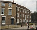
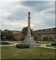
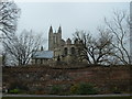
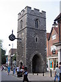
Photos of CT1 1PP


Area Information
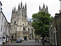
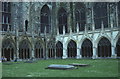
Living in CT1 1PP means being part of a tightly knit residential cluster within the historic city of Canterbury, a UNESCO World Heritage Site. The area covers just 1.0 hectare and is home to 1,373 people, making it one of the most densely populated postcode areas in England. Despite its small size, it sits within Barton Ward, a historic electoral district with roots in medieval Canterbury. Residents benefit from proximity to the city’s cultural and historical landmarks, including Barton Hall and Jesus Hospital, which add a layer of heritage to daily life. The area is not a sprawling suburb but a compact community, ideal for those seeking a blend of urban convenience and historical significance. With easy access to Canterbury’s rail network and major retail hubs, CT1 1PP offers a lifestyle that balances tradition with modern connectivity. However, its limited space means the area is highly specific—every resident is within walking distance of key amenities, creating a sense of intimacy that larger towns often lack.
- Area Type
- Postcode
- Area Size
- 1.0 hectares
- Population
- Not available
- Population Density
- Not available
The property market in CT1 1PP is characterised by a low home ownership rate of 28%, suggesting that the area is more rental-oriented than owner-occupied. The accommodation type is predominantly houses, which is atypical for a small, high-density postcode. This combination implies a mix of older, possibly period properties and smaller family homes, which may appeal to buyers seeking character or space in a compact setting. However, the limited area size means the housing stock is finite, and competition for properties could be fierce. For those considering purchase, the low ownership rate may indicate affordability issues or a preference for renting among residents. The proximity to Canterbury’s amenities and transport links could make the area attractive to buyers, though the small footprint means buyers must weigh the benefits of location against the constraints of limited housing availability.
House Prices in CT1 1PP
No properties found in this postcode.
Energy Efficiency in CT1 1PP
Residents of CT1 1PP have access to a range of amenities within practical reach, including major retail outlets like Tesco Canterbury, Waitrose Canterbury, and M&S Canterbury. These stores provide everything from daily essentials to luxury goods, supporting a convenient shopping experience. The area’s proximity to Canterbury’s rail network also means residents can easily access the city’s cultural and recreational offerings, from historic sites to parks and dining venues. While specific parks or leisure facilities are not detailed in the data, the presence of historic landmarks like Barton Hall and Jesus Hospital adds a unique character to the area. The compact nature of CT1 1PP means that amenities are closely clustered, reducing the need for long commutes. This creates a lifestyle where daily errands and leisure activities are efficiently managed, enhancing the overall quality of life for residents.
Amenities
Schools
| Rank | School | Type | Entry gender | Ages |
|---|
Explore more schools in this area
Go to Schools tabDemographics
CT1 1PP has a median age of 47, with the majority of residents falling into the 30-64 age range. This suggests a community of middle-aged adults, likely including professionals, families, and retirees. Home ownership is relatively low at 28%, indicating that a significant portion of the population rents their homes. The accommodation type is predominantly houses, which is unusual for a densely populated area, suggesting older properties or smaller family homes. The predominant ethnic group is White, though no specific data on diversity or deprivation is provided. The high population density—135,886 people per square kilometre—raises questions about housing pressure, though the data does not address this directly. For buyers, the demographic profile implies a stable, mature community with established local networks, though the low home ownership rate may reflect affordability challenges or a rental-focused market.
Household Size
Accommodation Type
Tenure
Ethnic Group
Religion
Household Composition
Age
Household Deprivation
NS-SEC
Explore more demographic insights in this area
Go to Demographics tabPlanning
Planning Constraints
- Flood RiskPremium
- Ramsar Wetland SitesPremium
- Area of Outstanding Natural BeautyPremium
- Protected Nature ReservePremium
- Protected WoodlandPremium
- Crime RiskPremium