Area Overview for CT1 1LS
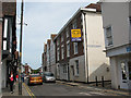
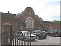
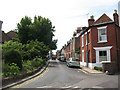
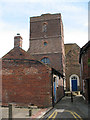
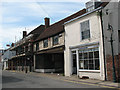
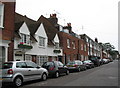
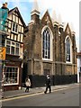
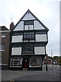
Photos of CT1 1LS
Area Information
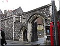
Living in CT1 1LS means inhabiting a compact, densely populated postcode area in Canterbury, Kent, where history and modernity intersect. With a population of 1,853 spread across 5,332 square metres, this small residential cluster is part of Northgate Ward, historically linked to Canterbury’s medieval walls and gates. The area’s proximity to the city centre offers easy access to its cultural and commercial hubs, while its compact size fosters a tight-knit community. Daily life here is shaped by proximity to transport links, local schools, and retail amenities, though the high population density means space is limited. The area’s historical roots, including the site of the demolished North Gate and St Mary Northgate Church, add a layer of heritage to its modern-day character. For buyers, CT1 1LS represents a blend of practicality and tradition, though its small footprint means opportunities for expansion are constrained.
- Area Type
- Postcode
- Area Size
- 5332 m²
- Population
- Not available
- Population Density
- Not available
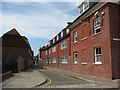
The property market in CT1 1LS is characterised by a high proportion of rented flats, with only 29% of homes owned by residents. This suggests a rental market that caters to transient populations, possibly students or young professionals, given the area’s proximity to Canterbury’s educational institutions. The dominance of flats over detached or semi-detached homes reflects the small area’s spatial constraints, limiting opportunities for larger properties. For buyers, this means limited availability of owner-occupied homes, with competition likely among those seeking long-term residency. The compact size of the postcode also means that properties are closely spaced, potentially affecting privacy and outdoor space. Buyers should consider the area’s suitability for those prioritising affordability and proximity to amenities over property size or type.
House Prices in CT1 1LS
No properties found in this postcode.
Energy Efficiency in CT1 1LS
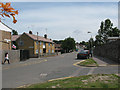
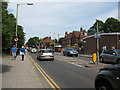
The lifestyle in CT1 1LS is shaped by its proximity to retail and transport hubs. Nearby amenities include Sainsburys Canterbury, M&S Canterbury, and other retail outlets, offering convenience for daily shopping. The rail network, with stations like Canterbury West and Sturry, provides direct links to the city’s commercial and cultural centres, enhancing accessibility. While the area lacks expansive parks or leisure facilities, its compact design ensures that essential services are within walking distance. The presence of the Northgate Ward Community Centre, established in 1997, adds a social dimension, though specific details about its offerings are not provided. Overall, the area’s lifestyle balances practicality with the vibrancy of Canterbury’s broader urban environment.
Amenities
Schools
Residents of CT1 1LS have access to several primary schools, including Kingsmead Primary School, Diocesan and Payne Smith Church of England Primary School, St Thomas’ Catholic Primary School, Canterbury (rated ‘good’ by Ofsted), and St Johns Church of England Primary School (also ‘good’). This mix of state and church-run schools provides families with options, though all are primary-level institutions. The presence of two ‘good’ rated schools suggests a baseline of quality in education, but parents seeking secondary schools will need to look beyond the immediate area. The concentration of primary schools reflects the area’s role as a residential hub for families with young children, though the lack of secondary schools nearby may impact long-term planning for households with older children.
| Rank | School | Type | Entry gender | Ages |
|---|---|---|---|---|
| 1 | Kingsmead Primary School | primary | N/A | N/A |
| 2 | Diocesan and Payne Smith Church of England Primary School | primary | N/A | N/A |
| 3 | St Thomas' Catholic Primary School, Canterbury | primary | N/A | N/A |
| 4 | St Johns Church of England Primary School | primary | N/A | N/A |
Explore more schools in this area
Go to Schools tabDemographics
The community in CT1 1LS is predominantly composed of adults aged 30–64, with a median age of 22, suggesting a mix of young professionals and families. Only 29% of residents own their homes, indicating a rental-heavy market, with flats making up the majority of accommodation types. The predominant ethnic group is White, reflecting broader trends in the area. The high population density of 347,543 people per square kilometre underscores the area’s compact nature, which may influence living conditions and community dynamics. While no specific deprivation data is provided, the low home ownership rate and high density could imply a reliance on shared resources and services. This profile suggests a community focused on affordability and accessibility, though it may lack the diversity seen in larger urban centres.
Household Size
Accommodation Type
Tenure
Ethnic Group
Religion
Household Composition
Age
Household Deprivation
NS-SEC
Explore more demographic insights in this area
Go to Demographics tabPlanning
Planning Constraints
- Flood RiskPremium
- Ramsar Wetland SitesPremium
- Area of Outstanding Natural BeautyPremium
- Protected Nature ReservePremium
- Protected WoodlandPremium
- Crime RiskPremium