Area Overview for BN6 8TS
Photos of BN6 8TS
Area Information
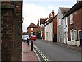
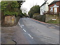
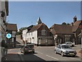
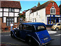
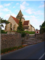
Ditchling, represented by the BN6 8TS postcode, is a historic hilltop village situated within the Lewes District of East Sussex. This specific residential cluster covers 1.7 hectares and is home to a population of 2554 residents. Defined by its location on the South Downs National Park, the area sits at a watershed between the Adur and Ouse catchments. The village has stood for centuries, first appearing in records from 765 AD and holding historical significance under King Alfred the Great. Today, life here blends modern rural living with a deep artistic legacy, characterised by over 40 listed buildings and a creative community rooted in the Arts and Crafts movement. You will find yourself in a setting crossed by the Roman Greensand Way, offering a direct connection to history through landmarks like St Margaret's Church and the Ditchling Museum of Art + Craft. The village maintains an authentic feel through traditions such as the biennial Ditchling Fair, originally granted in 1312. Residents enjoy living in BN6 8TS amidst this preserved environment, separated from high-density urban sprawl yet accessible to wider facilities. The small area size of 1.7 hectares means a close-knit community where the spread of homes is tightly contained. This setting appeals to those seeking a quiet, character-rich location away from the hustle of larger towns, while still benefiting from the infrastructure of nearby Hassocks and Burgess Hill. The combination of natural beauty, historical depth, and a stable population creates a distinct living experience for anyone choosing to settle in this specific postcode.
- Area Type
- Postcode
- Area Size
- 1.7 hectares
- Population
- 2554
- Population Density
- 107 people/km²
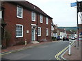
The property market in BN6 8TS is defined by a strong bias toward ownership rather than rental investment. With 83% of households classified as owner-occupied, the area functions as a established community of homeowners rather than a hub for transient tenants. This high ownership rate appeals to buyers seeking stability and those looking to purchase a home to live in for the long term. The predominant accommodation type is houses, which fits the rural village character of Ditchling and its surrounding parishes. Homes in BN6 8TS are likely to be detached or semi-detached properties, often with historical significance given the presence of over 40 listed buildings in the wider village. This accommodation type contrasts with the urban flats and apartments found in city centres, offering more land and privacy. For a specific postcode covering only 1.7 hectares, the supply of properties is naturally limited, which often supports stable or rising values for owner-occupiers. The data does not suggest a leasehold or high-rise market is present here. Anyone looking at BN6 8TS is entering a market characterised by permanent residents who invest in their homes. This environment is ideal for those who prefer managing a fixed asset rather than navigating the fluctuating needs of a rental sector. The housing stock reflects a traditional English village where families and retirees build roots in brick and stone.
House Prices in BN6 8TS
Showing 14 properties
| Address | Type | Beds | Baths | Last Sale Price | Last Sale Date | |
|---|---|---|---|---|---|---|
| 24 West Street, Ditchling, BN6 8TS | Detached | 5 | 3 | £2,041,970 | May 2025 | |
| 3 West Street, Ditchling, BN6 8TS | Terraced | 5 | 2 | £1,050,000 | Feb 2021 | |
| 28 West Street, Ditchling, BN6 8TS | Detached | 7 | - | £1,325,000 | Oct 2014 | |
| 26 West Street, Ditchling, BN6 8TS | house | - | - | £1,425,000 | Sep 2013 | |
| 14 West Street, Ditchling, BN6 8TS | house | 4 | - | £655,000 | Aug 2012 | |
| 22 West Street, Ditchling, BN6 8TS | Detached | - | - | £560,000 | Mar 2007 | |
| 18 West Street, Ditchling, BN6 8TS | Semi-detached | - | - | - | - | |
| Flat 1, 1 West Street, Ditchling, BN6 8TS | Flat | - | - | - | - | |
| Flat, The White Horse, 16 West Street, Ditchling, BN6 8TS | Flat | - | - | - | - | |
| 12 West Street, Ditchling, BN6 8TS | Terraced | - | - | - | - |
Energy Efficiency in BN6 8TS
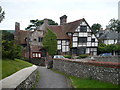
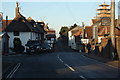
Daily life for residents of BN6 8TS benefits from several accessible amenities within practical reach. For retail needs, you have five local shops to choose from, including Morrisons Daily Hassocks 44, Sainsburys Hassocks, and Co-op Burgess. These venues provide comprehensive grocery shopping and everyday essentials without requiring a long drive. Transport links are equally well-developed, with access to at least five railway stations including Hassocks Railway Station and Burgess Hill Railway Station. These locations facilitate easy travel for social occasions or leisure shopping in larger towns. The village itself offers a rich cultural lifestyle rooted in its artistic history. The Ditchling Museum of Art + Craft showcases the local legacy of the Guild of St Joseph and St Dominic. You can explore St Margaret's Church, a landmark with origins dating back to the 11th century, or visit Wings Place, a Tudor house once gifted to Anne of Cleves. The biennial Ditchling Fair, a tradition granted in 1312, adds a unique seasonal event to your community calendar. Living in BN6 8TS allows you to balance village quietness with the convenience of nearby supermarkets and train stations. The presence of specific named shops and historical sites ensures your lifestyle is both functional and culturally engaging. Whether you need fresh bread from Co-op Burgess or a train to London, necessary facilities are just moments away.
Amenities
Schools
Families living near BN6 8TS have access to primary education through two specific local institutions. Ditchling St Margaret's Church of England Primary School serves the immediate community, offering religious education within a traditional framework. Just as an alternative or additional option, Ditchling (St Margaret's) Church of England Primary School operates in the vicinity. Both schools are located within the Ditchling parish, ensuring convenient access for residents of the small BN6 8TS cluster. As this area contains no secondary schools, older children in this specific postcode must travel to schools in nearby larger towns such as Hassocks or Hailsham. This is common for villages of this size within the South Downs National Park. The presence of two primary schools indicates a manageable catchment area for younger children without long commutes. Living in BN6 8TS means your young children can attend school within the village limits. The availability of these specific academies and church schools provides a definitive choice for parents prioritising local education. While the range is limited to primary level, the proximity of these facilities supports the needs of families with younger children. You will find the necessary educational foundation remains intact despite the area's small size.
| Rank | School | Type | Entry gender | Ages |
|---|
Explore more schools in this area
Go to Schools tabDemographics
The community in BN6 8TS presents a settled demographic profile typical of established rural villages. The median age for residents sits at 47 years, with the largest concentration of people falling into the elderly age range of 65 years and over. This older age structure suggests a neighbourhood where many individuals have long-term residency rather than a transient population. Home ownership is overwhelmingly dominant, with 83% of households owning their property outright or via mortgage. This high level of equity indicates stability and a lack of significant rental turnover within the BN6 8TS area. Accommodation consists primarily of houses, aligning with the village's historic character and lack of high-rise developments. The predominant ethnic group is White, reflecting the traditional demographic makeup of the region. With a population density of 107 people per square kilometre, the area feels spacious yet remains populated enough to sustain local services. The consistency between the population of 2554 and the area size of 1.7 hectares ensures a low density environment. Living in BN6 8TS means joining a community where the rhythm of life is likely influenced by this mature age profile. Families and retirees alike find a setting that matches their need for space and quieter surroundings. The data confirms a homogenous, owner-occupied population focused on established local living.
Household Size
Accommodation Type
Tenure
Ethnic Group
Religion
Household Composition
Age
Household Deprivation
NS-SEC
Explore more demographic insights in this area
Go to Demographics tabPlanning
Planning Constraints
- Flood RiskPremium
- Ramsar Wetland SitesPremium
- Area of Outstanding Natural BeautyPremium
- Protected Nature ReservePremium
- Protected WoodlandPremium