Area Overview for WA15 9PA
Photos of WA15 9PA

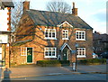
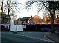
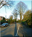
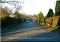


100 photos from this area
Area Information
Key information about the WA15 9PA including its size, population, and administrative classification.
- Area Type
- Postcode
- Area Size
- 4148 m²
- Population
- 1498
- Population Density
- 1696 people/km²
House Prices in WA15 9PA
12
Properties
£338,833
Average Sold Price
£185,000
Lowest Price
£746,000
Highest Price
Showing 12 properties
| Address | Type | Beds | Baths | Last Sale Price | Last Sale Date | |
|---|---|---|---|---|---|---|
| 26 Cecil Road, Hale, WA15 9PA | Semi-detached | 4 | 3 | £746,000 | Aug 2020 | |
| 14 Cecil Road, Hale, WA15 9PA | house | - | - | £375,000 | Feb 2014 | |
| 20 Cecil Road, Hale, WA15 9PA | Terraced | - | - | £285,000 | Apr 2007 | |
| 24 Cecil Road, Hale, WA15 9PA | Semi-detached | - | - | £244,500 | Dec 2005 | |
| 22 Cecil Road, Hale, WA15 9PA | Terraced | 3 | 1 | £185,000 | Dec 2002 | |
| 16 Cecil Road, Hale, WA15 9PA | Semi-detached | - | - | £197,500 | Oct 1999 | |
| Flat, 2A Cecil Road, Hale, WA15 9PA | Flat | - | - | - | - | |
| Dee Thai, 6 Cecil Road, Hale, WA15 9PA | Restaurant | - | - | - | - | |
| 14A Cecil Road, Hale, WA15 9PA | Semi-detached | - | - | - | - | |
| Second And Third Floors, 8 Cecil Road, Hale, WA15 9PA | Office | - | - | - | - |
Page 1 of 2
Energy Efficiency in WA15 9PA
Amenities
Schools
| Rank | School | Type | Entry gender | Ages |
|---|
Explore more schools in this area
Go to Schools tabDemographics
Household Size
Two person
most common
Accommodation Type
Houses
most common
Tenure
81
majority
Ethnic Group
White
most common
Religion
N/A
most common
Household Composition
N/A
most common
Age
47
median
Adults (30-64 years)
most common
Household Deprivation
N/A
with no deprivation
NS-SEC
60
in Lower managerial occupations
Explore more demographic insights in this area
Go to Demographics tabPlanning
Planning Constraints
- Flood RiskPremium
- Ramsar Wetland SitesPremium
- Area of Outstanding Natural BeautyPremium
- Protected Nature ReservePremium
- Protected WoodlandPremium