Area Overview for PR5 4DN
Photos of PR5 4DN
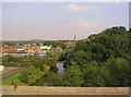


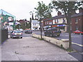
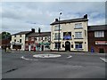


41 photos from this area
Area Information
Key information about the PR5 4DN including its size, population, and administrative classification.
- Area Type
- Postcode
- Area Size
- 9617 m²
- Population
- 1606
- Population Density
- 581 people/km²
House Prices in PR5 4DN
26
Properties
£100,833
Average Sold Price
£60,000
Lowest Price
£142,000
Highest Price
Showing 26 properties
| Address | Type | Beds | Baths | Last Sale Price | Last Sale Date | |
|---|---|---|---|---|---|---|
| 45 Kittlingbourne Brow, Higher Walton, Walton Le Dale, PR5 4DN | Terraced | 3 | 2 | £128,000 | Dec 2024 | |
| 41 Kittlingbourne Brow, Higher Walton, Walton Le Dale, PR5 4DN | Terraced | 3 | 1 | £97,000 | Sep 2024 | |
| 21 Kittlingbourne Brow, Higher Walton, Walton Le Dale, PR5 4DN | Terraced | 2 | 1 | £89,000 | Apr 2024 | |
| 49 Kittlingbourne Brow, Higher Walton, Walton Le Dale, PR5 4DN | Terraced | 3 | 1 | £142,000 | Nov 2023 | |
| 15 Kittlingbourne Brow, Higher Walton, Walton Le Dale, PR5 4DN | Terraced | 3 | 1 | £106,500 | Aug 2023 | |
| 35 Kittlingbourne Brow, Higher Walton, Walton Le Dale, PR5 4DN | Terraced | 2 | 1 | £135,000 | Mar 2023 | |
| 51A Kittlingbourne Brow, Higher Walton, Walton Le Dale, PR5 4DN | Terraced | 3 | 1 | £93,000 | Mar 2022 | |
| 33 Kittlingbourne Brow, Higher Walton, Walton Le Dale, PR5 4DN | Terraced | 2 | 1 | £135,000 | Mar 2022 | |
| 47 Kittlingbourne Brow, Higher Walton, Walton Le Dale, PR5 4DN | house | - | - | £75,000 | Jun 2021 | |
| 23 Kittlingbourne Brow, Higher Walton, Walton Le Dale, PR5 4DN | house | - | - | £110,000 | Jun 2021 |
Page 1 of 3
Energy Efficiency in PR5 4DN
Amenities
Schools
| Rank | School | Type | Entry gender | Ages |
|---|
Explore more schools in this area
Go to Schools tabDemographics
Household Size
Two person
most common
Accommodation Type
Houses
most common
Tenure
72
majority
Ethnic Group
White
most common
Religion
N/A
most common
Household Composition
N/A
most common
Age
47
median
Adults (30-64 years)
most common
Household Deprivation
N/A
with no deprivation
NS-SEC
32
in Lower managerial occupations
Explore more demographic insights in this area
Go to Demographics tabPlanning
Planning Constraints
- Flood RiskPremium
- Ramsar Wetland SitesPremium
- Area of Outstanding Natural BeautyPremium
- Protected Nature ReservePremium
- Protected WoodlandPremium