Area Overview for M21 8EF
Photos of M21 8EF
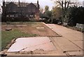

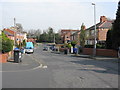


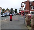
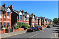
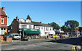
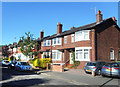
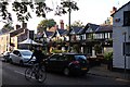
74 photos from this area
Area Information
Key information about the M21 8EF including its size, population, and administrative classification.
- Area Type
- Postcode
- Area Size
- 3.7 hectares
- Population
- 1529
- Population Density
- 1716 people/km²
House Prices in M21 8EF
20
Properties
£519,111
Average Sold Price
£128,000
Lowest Price
£880,000
Highest Price
Showing 20 properties
| Address | Type | Beds | Baths | Last Sale Price | Last Sale Date | |
|---|---|---|---|---|---|---|
| 21 Meadow Bank, Manchester, M21 8EF | house | - | - | £880,000 | Jul 2022 | |
| 15 Meadow Bank, Manchester, M21 8EF | house | - | - | £800,000 | Jan 2021 | |
| 3 Meadow Bank, Manchester, M21 8EF | house | - | - | £865,000 | Mar 2018 | |
| 31 Meadow Bank, Manchester, M21 8EF | house | - | - | £500,000 | Jan 2018 | |
| 19 Meadow Bank, Manchester, M21 8EF | house | - | - | £620,000 | Nov 2015 | |
| 17 Meadow Bank, Manchester, M21 8EF | house | - | - | £389,000 | May 2004 | |
| 35 Meadow Bank, Manchester, M21 8EF | Semi-detached | - | - | £250,000 | Sep 1998 | |
| 1 Meadow Bank, Manchester, M21 8EF | Semi-detached | 4 | 3 | £240,000 | May 1998 | |
| 9 Meadow Bank, Manchester, M21 8EF | Semi-detached | - | - | £128,000 | Jan 1997 | |
| 13 Meadow Bank, Manchester, M21 8EF | Semi-detached | 4 | 2 | - | - |
Page 1 of 2
Energy Efficiency in M21 8EF
Amenities
Schools
| Rank | School | Type | Entry gender | Ages |
|---|
Explore more schools in this area
Go to Schools tabDemographics
Household Size
Family (3-5 people)
most common
Accommodation Type
Houses
most common
Tenure
87
majority
Ethnic Group
White
most common
Religion
N/A
most common
Household Composition
N/A
most common
Age
47
median
Adults (30-64 years)
most common
Household Deprivation
N/A
with no deprivation
NS-SEC
64
in Lower managerial occupations
Explore more demographic insights in this area
Go to Demographics tabPlanning
Planning Constraints
- Flood RiskPremium
- Ramsar Wetland SitesPremium
- Area of Outstanding Natural BeautyPremium
- Protected Nature ReservePremium
- Protected WoodlandPremium