Area Overview for M21 8AZ
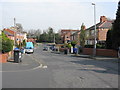
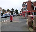
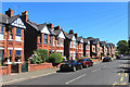
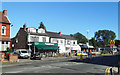
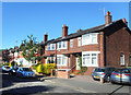
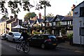
Photos of M21 8AZ


Area Information
Living in M21 8AZ means being part of a tightly knit residential cluster in England, where 1,427 people reside across 3,887 square metres. The area’s compact size creates a sense of intimacy, though its high population density of 367,141 people per square kilometre reflects the concentration of housing in a small footprint. This postcode is not a sprawling suburb but a focused community, with homes predominantly in private ownership. Daily life here is shaped by proximity to retail, transport, and green spaces, though the area’s character is defined by its practicality. Residents benefit from excellent broadband connectivity, with a score of 99, ensuring seamless digital access. However, the area’s safety profile is mixed: while flood risk is negligible, crime rates are notably high. For those prioritising convenience, M21 8AZ offers proximity to major transport hubs, including railway stations and airports, making it a viable option for commuters. The area’s appeal lies in its balance of accessibility and compact living, though buyers should weigh the trade-offs between connectivity and safety.
- Area Type
- Postcode
- Area Size
- 3887 m²
- Population
- 1427
- Population Density
- 9364 people/km²
The property market in M21 8AZ is characterised by a 48% home ownership rate, meaning nearly half of the housing stock is rented. This suggests a rental market that may cater to transient or younger residents, though the area’s primary accommodation type is houses. This is noteworthy in a high-density postcode, as houses are typically associated with larger plots and more private space. The limited number of properties—given the area’s small size—means the market is likely constrained, with few new developments. For buyers, this creates a challenge: the small footprint and focus on houses may limit availability, especially for those seeking flats or shared housing. However, the presence of houses could appeal to families or those prioritising space. Buyers should also consider the area’s safety profile, as high crime rates may influence property values and desirability.
House Prices in M21 8AZ
Showing 19 properties
| Address | Type | Beds | Baths | Last Sale Price | Last Sale Date | |
|---|---|---|---|---|---|---|
| 370A Barlow Moor Road, Manchester, M21 8AZ | Maisonette | - | - | £205,000 | Apr 2004 | |
| 350A Barlow Moor Road, Manchester, M21 8AZ | Flat | - | - | £90,000 | May 2000 | |
| 380A Barlow Moor Road, Manchester, M21 8AZ | Flat | 2 | 1 | £110,000 | Jul 1999 | |
| 370 Barlow Moor Road, Manchester, M21 8AZ | restaurant_cafe | - | - | - | - | |
| 356A Barlow Moor Road, Manchester, M21 8AZ | Flat | - | - | - | - | |
| 356 Barlow Moor Road, Manchester, M21 8AZ | restaurant_cafe | - | - | - | - | |
| Indian Affair, 362 Barlow Moor Road, Manchester, M21 8AZ | restaurant_cafe | - | - | - | - | |
| 360 Barlow Moor Road, Manchester, M21 8AZ | Retail | - | - | - | - | |
| 354A Barlow Moor Road, Manchester, M21 8AZ | Flat | - | - | - | - | |
| Flat 1, 352 Barlow Moor Road, Manchester, M21 8AZ | Flat | - | - | - | - |
Energy Efficiency in M21 8AZ
Life in M21 8AZ is defined by its proximity to retail, transport, and leisure. Residents have access to five major retail outlets, including Tesco Chorlton and Co-op Chorlton, ensuring everyday shopping needs are met locally. The area’s transport links are extensive, with five metro stops, such as Chorlton Station and Barlow Moor Road, and rail access to Manchester United FC Railway Station and Trafford Park Railway Station. This connectivity extends to air travel, with three airports—Terminal Two Access, Terminal One Access, and City Airport Manchester—within reach. For leisure, the area’s compact size means amenities are tightly clustered, though specific parks or recreational spaces are not mentioned in the data. The presence of multiple transport options and retail hubs suggests a lifestyle focused on convenience, with residents able to access work, shopping, and travel without long commutes. However, the lack of detailed information on green spaces or cultural venues leaves room for further inquiry.
Amenities
Schools
| Rank | School | Type | Entry gender | Ages |
|---|
Explore more schools in this area
Go to Schools tabDemographics
The community in M21 8AZ is predominantly middle-aged, with a median age of 47 and most residents falling within the 30-64 age range. This suggests a population skewed towards established adults, likely with families or long-term careers. Home ownership is relatively low at 48%, indicating a mix of owner-occupied and rental properties. The accommodation type is primarily houses, which is unusual for a densely populated area, hinting at a focus on single-family homes. The predominant ethnic group is White, though no specific diversity statistics are provided. The high population density, combined with a median age that suggests stability, implies a community where long-term residents may outnumber newcomers. For those considering M21 8AZ, the demographic profile suggests a mature, settled population, though the low home ownership rate could reflect economic pressures or a preference for renting in a high-cost area.
Household Size
Accommodation Type
Tenure
Ethnic Group
Religion
Household Composition
Age
Household Deprivation
NS-SEC
Explore more demographic insights in this area
Go to Demographics tabPlanning
Planning Constraints
- Flood RiskPremium
- Ramsar Wetland SitesPremium
- Area of Outstanding Natural BeautyPremium
- Protected Nature ReservePremium
- Protected WoodlandPremium