Area Overview for M21 8AY
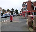
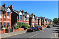
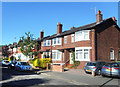
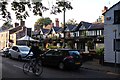
Photos of M21 8AY


Area Information
Living in M21 8AY means inhabiting a tightly packed residential cluster in England, where 1,492 people are spread across just 2.0 hectares. This results in a population density of 74,687 people per square kilometre, reflecting a densely populated, compact community. The area is defined by its small size and proximity to essential services, with a focus on housing rather than commercial development. Daily life here is shaped by the immediate availability of schools, retail, and transport links. The presence of multiple primary schools, including Chorlton Park Primary, suggests a family-oriented environment. While the area’s limited size means space is at a premium, its connectivity to nearby amenities and transport hubs offers convenience. However, the high density also means residents share close proximity to neighbours, creating a communal but potentially cramped living experience. The area’s character is defined by its residential focus, with homes predominating over other property types. For those seeking a compact, service-rich environment, M21 8AY offers proximity to essentials but demands tolerance for a densely packed lifestyle.
- Area Type
- Postcode
- Area Size
- 2.0 hectares
- Population
- 1492
- Population Density
- 4370 people/km²
M21 8AY’s property market is defined by its small size and high population density. With only 2.0 hectares of land and 1,492 residents, the area is dominated by houses, which account for all accommodation types listed. This suggests a focus on single-family homes, though the limited space means properties are likely compact. Home ownership rates at 48% indicate that nearly half the housing stock is rented, pointing to a market where rental demand is significant. For buyers, this means competition for properties, particularly given the area’s proximity to schools and transport. The small size of M21 8AY also means that any property purchase is likely to be within a tightly defined radius, with little scope for expansion. The predominance of houses over flats or apartments may appeal to those seeking traditional family homes, but the limited land area could restrict availability. Buyers should consider the area’s density as both an advantage—proximity to amenities—and a constraint—limited property options.
House Prices in M21 8AY
Showing 52 properties
| Address | Type | Beds | Baths | Last Sale Price | Last Sale Date | |
|---|---|---|---|---|---|---|
| 348 Barlow Moor Road, Manchester, M21 8AY | Terraced | 4 | 2 | £484,500 | Sep 2025 | |
| 328 Barlow Moor Road, Manchester, M21 8AY | Terraced | 4 | 1 | £333,500 | Aug 2025 | |
| 340 Barlow Moor Road, Manchester, M21 8AY | house | 4 | 2 | £380,000 | May 2024 | |
| 330 Barlow Moor Road, Manchester, M21 8AY | Unknown | - | - | £235,000 | Sep 2017 | |
| 322B Barlow Moor Road, Manchester, M21 8AY | Flat | - | - | £130,000 | Jun 2011 | |
| 336 Barlow Moor Road, Manchester, M21 8AY | house | - | - | £199,000 | Feb 2005 | |
| 326 Barlow Moor Road, Manchester, M21 8AY | Terraced | 1 | 2 | £135,000 | Nov 2002 | |
| Flat 2, 324C Barlow Moor Road, Manchester, M21 8AY | Flat | 1 | 1 | - | - | |
| Flat 11, 324C Barlow Moor Road, Manchester, M21 8AY | Flat | 2 | 2 | - | - | |
| Flat 15, 324C Barlow Moor Road, Manchester, M21 8AY | Flat | 2 | 2 | - | - |
Energy Efficiency in M21 8AY
Residents of M21 8AY have access to a range of amenities within practical reach. Retail options include Tesco Chorlton, M&S Chorlton-Cum, and Co-op Hardy, providing everyday shopping needs. The area’s transport infrastructure is extensive, with five metro stops, five rail stations, and multiple airport access points, including Terminal One, Two, and Three. Notable stations like Trafford Park Railway Station and Barlow Moor Road offer connections to surrounding areas. The presence of Chorlton Street Coach Station adds to the transport options. While the data does not mention parks or leisure facilities, the density of retail and transport hubs suggests a focus on convenience over green spaces. The area’s compact size means amenities are closely clustered, reducing travel time. However, the absence of specific details on parks or recreational areas leaves questions about outdoor leisure options. For those prioritising accessibility to shopping and transport, M21 8AY offers a practical, well-served environment.
Amenities
Schools
The area is served by four primary schools, all named Chorlton Park, with one holding an Ofsted rating of ‘good’. These include Chorlton Park Junior School, Chorlton Park Infants’ School, Chorlton Park Primary School, and Chorlton Park Primary (Ofsted: good). The repetition of the name suggests multiple campuses or phases of the same school, which may provide continuity for families with children at different ages. The presence of four primary schools in such a small area indicates a strong focus on education, likely meeting the needs of local families. However, the absence of secondary schools or other educational institutions means parents may need to look beyond M21 8AY for secondary education. The ‘good’ Ofsted rating at one school suggests at least one option meets quality standards, but the lack of diversity in school types—only primary—means the area’s educational offerings are limited to early years and primary levels.
| Rank | School | Type | Entry gender | Ages |
|---|
Explore more schools in this area
Go to Schools tabDemographics
The population of M21 8AY skews heavily towards adults aged 30–64, with a median age of 47. This suggests a community of established professionals and families, rather than a mix of younger or older demographics. Home ownership rates stand at 48%, indicating that nearly half of residents rent their homes, while the other 52% own property. The accommodation type is predominantly houses, which is unusual for such a small area but may reflect a focus on single-family dwellings. The predominant ethnic group is White, with no data provided on other demographics. The high population density—74,687 people per square kilometre—raises questions about living conditions, though it also implies a tightly knit community. For buyers, this suggests a mature, stable population with established needs, but potential challenges in finding larger properties or private outdoor space. The absence of specific data on deprivation or income levels means the area’s quality of life remains partially unquantified.
Household Size
Accommodation Type
Tenure
Ethnic Group
Religion
Household Composition
Age
Household Deprivation
NS-SEC
Explore more demographic insights in this area
Go to Demographics tabPlanning
Planning Constraints
- Flood RiskPremium
- Ramsar Wetland SitesPremium
- Area of Outstanding Natural BeautyPremium
- Protected Nature ReservePremium
- Protected WoodlandPremium