Area Overview for M21 8AN
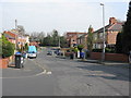
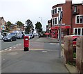
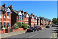
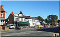
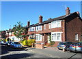
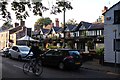
Photos of M21 8AN


Area Information
Living in M21 8AN means inhabiting a compact, high-density residential cluster in England. The area covers 3,814 square metres and is home to 1,427 people, translating to a population density of 374,196 people per square kilometre. This small postcode area is characterised by its close-knit community, with a median age of 47 and a majority of residents aged between 30 and 64. The housing stock is predominantly owner-occupied, with 48% of homes owned by residents, though the area’s size means property choices are limited. Daily life here is shaped by proximity to transport hubs, including multiple railway stations and bus routes, as well as retail outlets like Co-op Chorlton and Morrisons Whalley. While the area lacks natural reserves or protected landscapes, its strategic location near Manchester’s transport networks and airports offers practical connectivity. However, the high population density and limited space mean living here requires adaptability to a tightly packed environment.
- Area Type
- Postcode
- Area Size
- 3814 m²
- Population
- 1427
- Population Density
- 9364 people/km²
The property market in M21 8AN reflects a small, owner-occupied community with a focus on houses. At 48% home ownership, the area is not heavily reliant on rental properties, though the limited size of the postcode suggests a constrained market. The predominance of houses indicates a traditional housing stock, possibly with older or semi-detached properties, which may appeal to families or those seeking more space. However, the high population density and compact area mean property availability is limited, and buyers should consider the proximity to neighbours and potential noise or space constraints. For those seeking homes in M21 8AN, the market is likely niche, with properties prioritising proximity to transport links and amenities rather than expansive layouts. Buyers should also factor in the area’s proximity to major infrastructure, which may influence both property values and long-term desirability.
House Prices in M21 8AN
Showing 23 properties
| Address | Type | Beds | Baths | Last Sale Price | Last Sale Date | |
|---|---|---|---|---|---|---|
| 545 Barlow Moor Road, Manchester, M21 8AN | house | 5 | 3 | £741,000 | Nov 2021 | |
| Flat 5, 553 Barlow Moor Road, Manchester, M21 8AN | Flat | 1 | 1 | - | - | |
| Flat 4, 553 Barlow Moor Road, Manchester, M21 8AN | Flat | 1 | 1 | - | - | |
| Flat 2, 553 Barlow Moor Road, Manchester, M21 8AN | Flat | 1 | 1 | - | - | |
| Flat 3, 553 Barlow Moor Road, Manchester, M21 8AN | Flat | 1 | 1 | - | - | |
| Flat 3, 551 Barlow Moor Road, Manchester, M21 8AN | Flat | - | - | - | - | |
| Flat 4, 551 Barlow Moor Road, Manchester, M21 8AN | Flat | - | - | - | - | |
| Flat 1, 551 Barlow Moor Road, Manchester, M21 8AN | Flat | 1 | 1 | - | - | |
| Flat 2, 551 Barlow Moor Road, Manchester, M21 8AN | Flat | - | - | - | - | |
| Flat 3, 549 Barlow Moor Road, Manchester, M21 8AN | Flat | - | - | - | - |
Energy Efficiency in M21 8AN
Residents of M21 8AN have access to a range of amenities within easy reach. Retail options include Co-op Chorlton, Morrisons Whalley, and other local stores, providing everyday shopping convenience. The area’s transport network connects to multiple railway stations, such as Chorlton and Barlow Moor Road, enabling quick travel to nearby towns and cities. For leisure, proximity to Trafford Park and Manchester United FC railway stations suggests access to sports and cultural events. Airports like City Airport Manchester and Terminal One Access are within reach, catering to frequent travellers. While the data does not specify parks or recreational spaces, the presence of multiple transport hubs and retail outlets indicates a lifestyle focused on practicality and connectivity. The compact nature of the area means amenities are densely packed, which can be both a convenience and a challenge for those seeking more open spaces.
Amenities
Schools
| Rank | School | Type | Entry gender | Ages |
|---|
Explore more schools in this area
Go to Schools tabDemographics
The community in M21 8AN is predominantly composed of adults aged 30 to 64, with a median age of 47. This suggests a mature, stable population, likely with established careers and family ties. Home ownership stands at 48%, indicating a balance between owner-occupied and rental properties. The accommodation type is primarily houses, which is unusual for a high-density area, suggesting a mix of traditional housing and possibly smaller family homes. The predominant ethnic group is White, though the data does not specify further diversity metrics. With 1,427 residents in a small area, the community is likely tight-knit, though the high population density may impact social dynamics. The absence of detailed deprivation data means quality of life factors like access to services or employment opportunities are not quantified here, but the proximity to transport and retail suggests practicality for daily needs.
Household Size
Accommodation Type
Tenure
Ethnic Group
Religion
Household Composition
Age
Household Deprivation
NS-SEC
Explore more demographic insights in this area
Go to Demographics tabPlanning
Planning Constraints
- Flood RiskPremium
- Ramsar Wetland SitesPremium
- Area of Outstanding Natural BeautyPremium
- Protected Nature ReservePremium
- Protected WoodlandPremium