Area Overview for M21 8AD
Photos of M21 8AD


Area Information
Living in M21 8AD means inhabiting a tightly packed residential cluster of 3,230 square metres, home to 1,696 people. The area’s population density of 525,096 people per square kilometre reflects its compact nature, with most properties being flats. This postcode is a microcosm of urban living, where proximity to amenities and transport hubs is key. Residents here are predominantly adults aged 30–64, a demographic that shapes the area’s rhythm. The presence of multiple schools, retail outlets, and transport links suggests a community focused on practicality and accessibility. While the area lacks natural landscapes or protected sites, its strategic location near major infrastructure, including railway stations and airports, offers convenience for commuters and frequent travellers. However, the high population density and limited green space may appeal to those prioritising connectivity over open spaces. For buyers, M21 8AD is a small, defined area where every detail of daily life is closely interwoven with its immediate surroundings.
- Area Type
- Postcode
- Area Size
- 3230 m²
- Population
- 1696
- Population Density
- 6914 people/km²
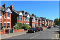
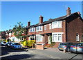
The property market in M21 8AD is characterised by a high concentration of flats, with home ownership at just 27%. This indicates that the area functions more as a rental market than an owner-occupied one. The limited number of properties—given the small area size—means the housing stock is tightly controlled, with few opportunities for buyers seeking larger or detached homes. Most residents are likely to be tenants, possibly students or professionals requiring short-term accommodation. The prevalence of flats may appeal to those prioritising affordability and proximity to transport, but it also means the market is less dynamic for buyers. For those considering purchase, the area’s small size and lack of varied housing types suggest exploring nearby postcodes for more options. The compact nature of M21 8AD ensures that any property here is likely to be within walking distance of essential services, though the limited availability may drive up competition among buyers.
House Prices in M21 8AD
Showing 25 properties
| Address | Type | Beds | Baths | Last Sale Price | Last Sale Date | |
|---|---|---|---|---|---|---|
| 420A Barlow Moor Road, Manchester, M21 8AD | Flat | 3 | 1 | £350,000 | Sep 2025 | |
| 426A Barlow Moor Road, Manchester, M21 8AD | Flat | - | - | £117,000 | Sep 2003 | |
| 424A Barlow Moor Road, Manchester, M21 8AD | Flat | - | - | £130,000 | Nov 2000 | |
| 402A Barlow Moor Road, Manchester, M21 8AD | Flat | 3 | 1 | £85,000 | Jul 2000 | |
| 408B Barlow Moor Road, Manchester, M21 8AD | Maisonette | - | - | £105,000 | Jul 1997 | |
| 422B Barlow Moor Road, Manchester, M21 8AD | Flat | 1 | 1 | £150,000 | May 1995 | |
| 406B Barlow Moor Road, Manchester, M21 8AD | Flat | 2 | 1 | - | - | |
| Jp & Brimelow, 430 Barlow Moor Road, Manchester, M21 8AD | Office | - | - | - | - | |
| Diy & Household, 414 Barlow Moor Road, Manchester, M21 8AD | retail_financial | - | - | - | - | |
| Flat Over, 416 Barlow Moor Road, Manchester, M21 8AD | Flat | - | - | - | - |
Energy Efficiency in M21 8AD
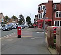
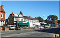
Life in M21 8AD is shaped by its proximity to retail, transport, and leisure facilities. The area’s five retail outlets, including Co-op Chorlton and Tesco Chorlton, offer everyday shopping needs, while the presence of multiple railway stations ensures easy access to nearby destinations. The nearby airports, such as City Airport Manchester, provide convenience for frequent flyers. For leisure, the area’s transport links connect residents to parks, cultural venues, and recreational spaces beyond the immediate postcode. The compact layout means amenities are within walking distance, fostering a sense of accessibility. However, the lack of detailed information on parks or green spaces suggests that outdoor activities may require travel to adjacent areas. The mix of retail, transport, and connectivity options makes M21 8AD suitable for those who prioritise convenience and proximity to urban services over expansive natural environments.
Amenities
Schools
M21 8AD is served by three primary schools: Oswald Road Infant School, Oswald Road Junior School, and Oswald Road Primary School, which holds a ‘good’ Ofsted rating. These institutions cater to younger children, providing a range of educational options for families. The presence of multiple primary schools within the area suggests a focus on early education, though secondary schools would need to be located elsewhere. The ‘good’ rating at Oswald Road Primary indicates a reasonably high standard of teaching and facilities, which could be a draw for families prioritising school quality. However, the absence of secondary schools in the immediate vicinity means parents may need to consider commuting for older children. The concentration of primary schools also implies a community with a significant number of young families, shaping the area’s social dynamics.
| Rank | School | Type | Entry gender | Ages |
|---|
Explore more schools in this area
Go to Schools tabDemographics
The community in M21 8AD is predominantly composed of adults aged 30–64, with a median age of 47. This suggests a mature population, likely with established careers and families. Home ownership is low at 27%, indicating that most residents are renters, possibly students or professionals in transient roles. The accommodation type is primarily flats, reflecting the area’s high density. The predominant ethnic group is White, with no specific data on other demographics provided. The age profile and housing stock suggest a stable but not rapidly growing population. The absence of detailed diversity metrics means the community’s cultural composition remains unclear. For quality of life, the age range implies a balance between younger families and older residents, though the low home ownership rate may affect long-term stability. The area’s compact size and focused amenities cater to those prioritising convenience over expansive living spaces.
Household Size
Accommodation Type
Tenure
Ethnic Group
Religion
Household Composition
Age
Household Deprivation
NS-SEC
Explore more demographic insights in this area
Go to Demographics tabPlanning
Planning Constraints
- Flood RiskPremium
- Ramsar Wetland SitesPremium
- Area of Outstanding Natural BeautyPremium
- Protected Nature ReservePremium
- Protected WoodlandPremium