Area Overview for L4 0TH
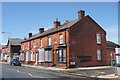
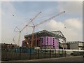
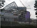
Photos of L4 0TH


Area Information
Living in L4 0TH means inhabiting a tightly packed residential cluster in England’s north-west, where 1567 people are spread across just 1.9 hectares. This density creates a compact, almost village-like feel, though the area’s small size means it is likely integrated into a larger urban fabric. The postcode’s proximity to retail, rail, and ferry networks suggests it is well-situated for those prioritising connectivity. With a median age of 47 and a population skewed toward adults aged 30–64, the community here is established, with a strong presence of home owners (41%) and a majority of White residents. Daily life is shaped by the area’s limited space and high population density, which may foster a tight-knit but potentially crowded environment. The absence of natural constraints like AONB or protected woodlands means development is unencumbered, though the area’s high crime risk—22/100—demands caution. For buyers, L4 0TH offers a snapshot of urban living with a focus on accessibility over open space.
- Area Type
- Postcode
- Area Size
- 1.9 hectares
- Population
- 1567
- Population Density
- 2899 people/km²
L4 0TH’s property market is characterised by a 41% home ownership rate, suggesting that nearly half of properties are rented. The accommodation type is predominantly houses, which may indicate a preference for detached or semi-detached homes in this small area. Given the high population density and limited space, it is likely that properties are smaller or multi-generational. The area’s compact size means buyers must consider whether the immediate surroundings offer more housing diversity. For those seeking owner-occupied homes, the 41% ownership rate implies a rental market that may be competitive. However, the lack of data on property prices or types limits deeper analysis. Buyers should also weigh the area’s high crime risk against its proximity to transport and retail amenities, which may offset concerns about safety.
House Prices in L4 0TH
Showing 6 properties
| Address | Type | Beds | Baths | Last Sale Price | Last Sale Date | |
|---|---|---|---|---|---|---|
| Former 28, Tinsley Street, Liverpool, L4 0TH | Terraced | - | - | - | - | |
| Study Centre, Liverpool Football Club, Anfield Road, Liverpool, L4 0TH | commercial | - | - | - | - | |
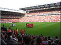
| The Kop Bar, Liverpool Football Club, Anfield Road, Liverpool, L4 0TH | Restaurant | - | - | - | - | |
| Family Park, Liverpool Football Club, Anfield Road, Liverpool, L4 0TH | Leisure | - | - | - | - | |
| Mcdonald's, Mcdonalds, Walton Breck Road, Liverpool, L4 0TH | Restaurant | - | - | - | - | |
| Liverpool Football Club Museum, Walton Breck Road, Liverpool, L4 0TH | Leisure | - | - | - | - |
Energy Efficiency in L4 0TH
Residents of L4 0TH have access to a range of nearby amenities, including five retail outlets such as Morrisons Daily, Spar, and Aldi Kirkdale, ensuring daily shopping needs are met within reach. The area’s rail network, with stations like Kirkdale and Bank Hall, provides easy access to urban centres, while three ferry terminals—Liverpool Belfast, Pier Head, and Isle of Man—open up maritime travel options. Though the area itself is small, its proximity to these amenities suggests a lifestyle that balances convenience with urban connectivity. The presence of multiple retail and transport hubs implies a dynamic, service-rich environment, though the lack of parks or leisure facilities in the data means recreational options may be limited to nearby areas. For those prioritising accessibility over green space, L4 0TH offers a practical, if compact, living experience.
Amenities
Schools
| Rank | School | Type | Entry gender | Ages |
|---|
Explore more schools in this area
Go to Schools tabDemographics
The population of L4 0TH is predominantly adults aged 30–64, with a median age of 47. This suggests a mature, stable community with a focus on established households rather than younger families or retirees. Home ownership stands at 41%, indicating a mix of owner-occupied properties and rentals. The accommodation type is primarily houses, which may reflect a preference for single-family living in a compact area. The predominant ethnic group is White, though no data is provided on minority representation. The high population density—82,219 people per square kilometre—raises questions about housing pressures and the potential for overcrowding. While the area’s demographics suggest a settled, middle-aged population, the lack of data on deprivation or income levels means it is unclear how this translates to quality of life. Buyers should consider whether the demographic profile aligns with their lifestyle needs.
Household Size
Accommodation Type
Tenure
Ethnic Group
Religion
Household Composition
Age
Household Deprivation
NS-SEC
Explore more demographic insights in this area
Go to Demographics tabPlanning
Planning Constraints
- Flood RiskPremium
- Ramsar Wetland SitesPremium
- Area of Outstanding Natural BeautyPremium
- Protected Nature ReservePremium
- Protected WoodlandPremium