Area Overview for L27 7AF
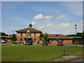
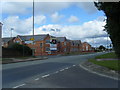
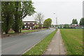
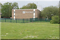
Photos of L27 7AF
Area Information
Living in L27 7AF means inhabiting a tightly knit residential cluster in England, where 1,406 people reside across 5,735 square metres. This small area is defined by its compact size and high population density of 245,155 people per square kilometre, creating a densely populated yet manageable community. The area’s proximity to key amenities, including five retail outlets, three railway stations, and two airports, ensures residents have practical access to daily necessities and travel options. Daily life here is shaped by its small-scale nature, with a median age of 47 and a population skewed toward adults aged 30–64. The area’s safety profile is strong, with a crime risk score of 70 and low flood risk, offering reassurance for families and professionals. While the housing stock is predominantly owner-occupied (48%), the compact footprint means the local market is limited to a few properties. This makes L27 7AF a niche area for buyers seeking a quiet, well-connected residential spot with minimal environmental constraints.
- Area Type
- Postcode
- Area Size
- 5735 m²
- Population
- 1406
- Population Density
- 2240 people/km²
The property market in L27 7AF is characterised by a 48% home ownership rate, with houses forming the predominant accommodation type. This suggests a mix of owner-occupied and rental properties, though the small area size—just 5,735 square metres—means the housing stock is limited. The compact footprint implies that buyers will find few properties available, and those that exist are likely to be in close proximity to one another. Given the area’s high population density, properties here are likely to be smaller in size, prioritising space efficiency over expansive layouts. For buyers, this means competition may be fierce, and the market is more suited to those seeking a quiet, established residential environment rather than large-scale investment. The proximity to rail stations and retail hubs also adds to the area’s appeal for commuters and families.
House Prices in L27 7AF
Showing 2 properties
| Address | Type | Beds | Baths | Last Sale Price | Last Sale Date | |
|---|---|---|---|---|---|---|
| Netherley Health Centre, Middlemass Hey, Liverpool, L27 7AF | hospital_care_home | - | - | - | - | |
| The Pharmacy, Netherley Health Centre, Middlemass Hey, Liverpool, L27 7AF | commercial | - | - | - | - |
Energy Efficiency in L27 7AF
The lifestyle in L27 7AF is shaped by its proximity to essential amenities, including five retail outlets such as Spar, Morrisons Belle, and Iceland Belle. These shops provide access to groceries, convenience goods, and other daily necessities, reducing the need for long trips. The area’s rail stations connect residents to broader transport networks, while the two nearby airports offer travel options for those requiring frequent flights. Though the data does not mention parks or leisure facilities, the compact nature of the area suggests that residents may rely on nearby towns for larger recreational spaces. The combination of retail, rail, and air connectivity creates a practical, efficient lifestyle, ideal for those prioritising convenience over expansive leisure options.
Amenities
Schools
Residents of L27 7AF have access to two primary schools: St Gregory’s Catholic Primary School, which holds an Ofsted rating of ‘good,’ and St Gregory’s RC Infant School. Both institutions cater to younger children, providing a range of educational options for families. The presence of two primary schools within the area ensures that parents have choices, though no secondary schools are listed in the data. This focus on primary education suggests the area is well-suited for families with young children, though those requiring secondary schooling may need to look beyond the immediate vicinity. The ‘good’ rating at St Gregory’s Catholic Primary School indicates a reliable standard of education, which is a key consideration for homebuyers prioritising schools.
| Rank | School | Type | Entry gender | Ages |
|---|
Explore more schools in this area
Go to Schools tabDemographics
The community in L27 7AF is composed of 1,406 residents, with a median age of 47 and a majority of adults aged 30–64. This suggests a mature, stable population with established careers and family structures. Home ownership is at 48%, slightly below the national average, indicating a mix of owner-occupied and rental properties. The area is predominantly composed of houses, reflecting a traditional housing stock that contrasts with higher-density urban areas. The predominant ethnic group is White, though no specific data on diversity or deprivation is provided. The high population density—245,155 people per square kilometre—means the area is intensely populated, which may influence local services and social dynamics. For residents, this density translates to a tightly woven community where proximity to amenities and neighbours is a defining feature.
Household Size
Accommodation Type
Tenure
Ethnic Group
Religion
Household Composition
Age
Household Deprivation
NS-SEC
Explore more demographic insights in this area
Go to Demographics tabPlanning
Planning Constraints
- Flood RiskPremium
- Ramsar Wetland SitesPremium
- Area of Outstanding Natural BeautyPremium
- Protected Nature ReservePremium
- Protected WoodlandPremium