Area Overview for L27 7AE
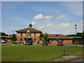
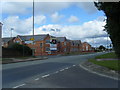
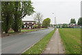
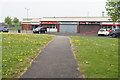
Photos of L27 7AE


Area Information
Living in L27 7AE offers a compact, tightly knit residential experience within a small cluster of 3.7 hectares. With a population of 1,862, the area is densely populated at 1,570 people per square kilometre, creating a close-knit community feel. This postcode is characterised by its focus on family-oriented living, with a median age of 47 and a majority of residents aged 30–64. The area’s housing stock is predominantly owner-occupied, with 51% of homes owned by residents, and most properties are traditional houses. Daily life here is shaped by proximity to local amenities, including multiple retail outlets, rail stations, and schools. The compact size of L27 7AE means residents are likely to know their neighbours, though the area’s small footprint also means limited space for expansion. Its location near major transport routes, such as Huyton and Halewood railway stations, ensures easy access to nearby cities, while the presence of two airports nearby adds to its connectivity. For those seeking a balance between suburban tranquillity and urban accessibility, L27 7AE offers a distinct blend of practicality and community focus.
- Area Type
- Postcode
- Area Size
- 3.7 hectares
- Population
- 1862
- Population Density
- 1570 people/km²
The property market in L27 7AE is shaped by its 51% home ownership rate and the predominance of houses as the primary accommodation type. This indicates a community where family homes are the norm, with fewer apartments or flats. The relatively high proportion of owner-occupied properties suggests a stable market, though the small area size of 3.7 hectares limits the availability of new developments. Buyers should consider that the housing stock is likely to be older, given the median age of residents, which may influence property condition and renovation needs. The area’s proximity to rail stations, such as Huyton and Halewood, could enhance its appeal for commuters, though the compact size means limited scope for expansion. For those seeking a family home with established infrastructure, L27 7AE offers a blend of practicality and accessibility, though buyers may need to evaluate individual property specifics for long-term value.
House Prices in L27 7AE
Showing 44 properties
| Address | Type | Beds | Baths | Last Sale Price | Last Sale Date | |
|---|---|---|---|---|---|---|
| 3 Brownbill Bank, Liverpool, L27 7AE | Terraced | 2 | 1 | £139,950 | Jul 2025 | |
| 7 Brownbill Bank, Liverpool, L27 7AE | Terraced | 2 | 1 | £143,100 | Nov 2023 | |
| School House, Brownbill Bank, Liverpool, L27 7AE | Bungalow | 5 | 1 | £140,000 | Mar 2023 | |
| 26 Brownbill Bank, Liverpool, L27 7AE | house | - | - | £125,000 | Jan 2022 | |
| 31 Brownbill Bank, Liverpool, L27 7AE | Terraced | 3 | 1 | £94,950 | Oct 2016 | |
| 14 Brownbill Bank, Liverpool, L27 7AE | Terraced | 3 | 1 | £88,500 | May 2016 | |
| 21 Brownbill Bank, Liverpool, L27 7AE | Terraced | - | - | £78,000 | Nov 2006 | |
| 34 Brownbill Bank, Liverpool, L27 7AE | Terraced | - | - | £35,000 | Mar 2003 | |
| Christ Church House, 70 Brownbill Bank, Liverpool, L27 7AE | Semi-detached | 3 | 1 | - | - | |
| Food For Thought, 44 Brownbill Bank, Liverpool, L27 7AE | Restaurant | - | - | - | - |
Energy Efficiency in L27 7AE
Residents of L27 7AE benefit from a selection of retail amenities, including Spar, Morrisons Belle, and Iceland Belle, which cater to everyday shopping needs. The area’s rail stations—Huyton, Halewood, and Roby—offer frequent services, connecting locals to broader transport networks and nearby cities. Proximity to Liverpool John Lennon Airport enhances travel convenience for both business and leisure. While the data does not specify parks or leisure facilities, the presence of multiple retail and transport hubs suggests a lifestyle focused on practicality and accessibility. The compact nature of the area means amenities are closely clustered, reducing travel times for daily errands. For those prioritising convenience, the combination of shopping, rail access, and airport proximity makes L27 7AE a functional choice, though recreational spaces may require venturing slightly further afield.
Amenities
Schools
Residents of L27 7AE have access to a range of educational institutions, including Norman Pannell Primary School, which holds a ‘good’ Ofsted rating, and Lee Manor High School, though its type is listed as primary, which may be an error. Additional primary schools include Norman Pannell County Infant School, catering to younger children, and Willowfield School, a special needs institution. This mix of school types provides families with options for both mainstream and specialist education. The presence of multiple primary schools suggests a focus on early education, while the special school accommodates diverse learning needs. However, the lack of secondary schools in the immediate area may require students to travel to nearby towns for further education. For families prioritising local schooling, the availability of primary options is a strong point, though secondary education planning would need to consider commuting distances.
| Rank | School | Type | Entry gender | Ages |
|---|
Explore more schools in this area
Go to Schools tabDemographics
The demographic profile of L27 7AE is defined by its mature population, with a median age of 47 and a majority of residents aged 30–64. This suggests a community with established families and professionals, likely contributing to the area’s stable housing market. Home ownership stands at 51%, indicating a mix of owner-occupied properties and rental stock, though the data does not specify the latter’s proportion. The predominant accommodation type is houses, which aligns with the demographic’s preference for family homes. The area’s population density of 1,570 people per square kilometre reflects a tightly packed residential environment, which may influence local services and infrastructure. The predominant ethnic group is White, though no further breakdown of diversity is provided. For buyers, this demographic suggests a community with long-term residency patterns and a focus on family-oriented living, which may impact the types of amenities and services available.
Household Size
Accommodation Type
Tenure
Ethnic Group
Religion
Household Composition
Age
Household Deprivation
NS-SEC
Explore more demographic insights in this area
Go to Demographics tabPlanning
Planning Constraints
- Flood RiskPremium
- Ramsar Wetland SitesPremium
- Area of Outstanding Natural BeautyPremium
- Protected Nature ReservePremium
- Protected WoodlandPremium