Area Overview for BB12 8RN
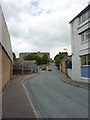
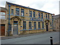
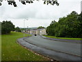
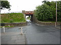
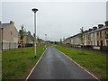
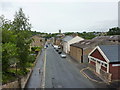
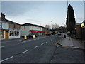
Photos of BB12 8RN

Area Information
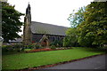
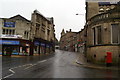
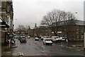
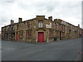
Living in BB12 8RN, a small residential cluster in Lancashire’s Burnley Borough, means inhabiting a place steeped in history yet defined by its compact, community-driven character. The area covers 3,923 square metres, housing 1,536 residents in a densely populated setting. Padiham, the town associated with this postcode, has roots in Anglo-Saxon settlement, evolving from a market town trading Pendleside produce. Today, its conservation area status preserves historic architecture, including St Leonard’s Parish Church and the 19th-century Victoria Mill, now converted into flats. The area’s proximity to natural landmarks like Pendle Hill and the nearby Gawthorpe Hall—a 16th-century National Trust site—offers easy access to countryside and heritage. Despite its small size, BB12 8RN is connected to Burnley and the wider region via rail, with stations like Hapton and Rose Grove within reach. The blend of preserved history, practical amenities, and transport links makes this postcode a distinctive choice for those seeking a compact, well-connected residential environment.
- Area Type
- Postcode
- Area Size
- 3923 m²
- Population
- 1536
- Population Density
- 9942 people/km²
The property market in BB12 8RN is defined by a 48% home ownership rate, with houses making up the majority of accommodation types. This suggests a focus on owner-occupied homes rather than a rental-dominated market, though the relatively low home ownership figure indicates a significant proportion of the housing stock is rented. The small area size and historical character of the town mean properties are likely to be older, with potential for restoration or conversion, as seen in the repurposed Victoria Mill. Buyers should consider the limited space and the fact that the area is a small cluster rather than a large suburb, which may affect availability of new builds. The presence of listed buildings and conservation area status could also influence property values and planning restrictions, making this a niche market for those seeking historic homes in a compact, well-connected town.
House Prices in BB12 8RN
Showing 25 properties
| Address | Type | Beds | Baths | Last Sale Price | Last Sale Date | |
|---|---|---|---|---|---|---|
| 23 Cardwell Street, Padiham, BB12 8RN | Terraced | 2 | 1 | £81,000 | Oct 2025 | |
| 47 Cardwell Street, Padiham, BB12 8RN | Terraced | 2 | 1 | £66,000 | Nov 2019 | |
| 17 Cardwell Street, Padiham, BB12 8RN | house | - | - | £56,000 | May 2019 | |
| 21 Cardwell Street, Padiham, BB12 8RN | Terraced | 2 | 1 | £55,000 | Jun 2018 | |
| 49 Cardwell Street, Padiham, BB12 8RN | Terraced | 3 | 1 | £48,500 | May 2018 | |
| 35 Cardwell Street, Padiham, BB12 8RN | Terraced | 3 | 1 | £80,000 | Dec 2016 | |
| 27 Cardwell Street, Padiham, BB12 8RN | house | 3 | - | £70,000 | Jan 2012 | |
| 13 Cardwell Street, Padiham, BB12 8RN | house | - | - | £61,500 | Apr 2010 | |
| 19 Cardwell Street, Padiham, BB12 8RN | Terraced | 3 | 1 | £110,000 | May 2008 | |
| 39 Cardwell Street, Padiham, BB12 8RN | Terraced | 3 | 1 | £68,500 | Jul 2006 |
Energy Efficiency in BB12 8RN
Life in BB12 8RN is shaped by its small-town amenities and historical character. Within practical reach are retail options like Tesco Padiham, Lidl Padiham, and Spar, offering everyday shopping needs. The rail network, with stations such as Hapton and Rose Grove, connects residents to Burnley and further afield, while the nearby Leeds and Liverpool Canal provides a scenic backdrop. The area’s conservation status means historic sites like St Leonard’s Parish Church and Victoria Mill coexist with modern living. Though the town lacks large commercial centres, its proximity to Pendle Hill and Gawthorpe Hall offers opportunities for outdoor activities and cultural exploration. The compact nature of BB12 8RN ensures a tight-knit community feel, with daily life revolving around local shops, historic landmarks, and accessible transport links.
Amenities
Schools
| Rank | School | Type | Entry gender | Ages |
|---|
Explore more schools in this area
Go to Schools tabDemographics
BB12 8RN’s population of 1,536 is predominantly adults aged 30–64, reflecting a median age of 47. This suggests a mature, stable community with a focus on established households rather than young families. Home ownership stands at 48%, indicating a mix of owner-occupied properties and rental stock. The accommodation type is primarily houses, which aligns with the area’s character as a small town rather than a high-density urban space. The predominant ethnic group is White, though no specific data on diversity or deprivation levels is provided. The age profile implies a population likely engaged in mature careers or retirement, with fewer children in the area. This demographic structure may influence local services and amenities, shaping a community that prioritises practicality over child-centric infrastructure.
Household Size
Accommodation Type
Tenure
Ethnic Group
Religion
Household Composition
Age
Household Deprivation
NS-SEC
Explore more demographic insights in this area
Go to Demographics tabPlanning
Planning Constraints
- Flood RiskPremium
- Ramsar Wetland SitesPremium
- Area of Outstanding Natural BeautyPremium
- Protected Nature ReservePremium
- Protected WoodlandPremium