Area Overview for BB12 8AH
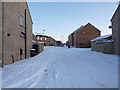
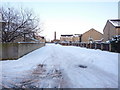
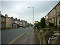
Photos of BB12 8AH

Area Information
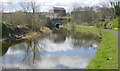
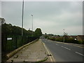
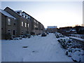
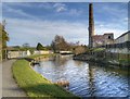
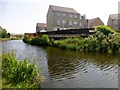
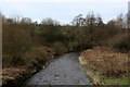
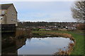
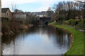
Living in BB12 8AH means inhabiting a compact, residential cluster nestled in the Borough of Burnley, Lancashire. This postcode covers 2.8 hectares, housing 1,448 people in a densely populated area with 50,962 residents per square kilometre. Its location north of Burnley town centre places it near the Leeds and Liverpool Canal, a historic waterway that once spurred industrial activity, including coal operations at Gannow Wharf. The area’s character is shaped by its proximity to the M65 motorway, which divides it from surrounding districts. BB12 8AH is part of Gannow Ward, a community with roots in 19th-century industrial growth and 20th-century housing expansion. Today, it balances its heritage with modern amenities like the Gannow Business Park, repurposed from Victorian cotton mills. Residents benefit from nearby rail links, including Burnley Central and Rose Grove stations, and a mix of retail options. The area’s compact size fosters a tight-knit community, though its density may feel limiting for those seeking larger living spaces. For buyers, BB12 8AH offers a blend of historical charm and practical connectivity, ideal for those prioritising proximity to transport and local services.
- Area Type
- Postcode
- Area Size
- 2.8 hectares
- Population
- 1448
- Population Density
- 3748 people/km²
The property market in BB12 8AH is dominated by owner-occupied homes, with 70% of residents living in properties they own. The primary accommodation type is houses, which aligns with the area’s residential character and historical development as a cluster of detached or semi-detached homes. Given the postcode’s small size—just 2.8 hectares—the housing stock is limited, making it a niche market for buyers seeking specific properties. The proximity to rail stations like Burnley Central and Rose Grove may appeal to commuters, while the nearby Gannow Business Park could offer opportunities for investment or flexible living spaces. However, the compact nature of BB12 8AH means that buyers should consider the immediate surroundings for additional options. The high home ownership rate suggests a stable market with potential for long-term value retention, though the limited supply may result in competitive bidding for available properties.
House Prices in BB12 8AH
Showing 13 properties
| Address | Type | Beds | Baths | Last Sale Price | Last Sale Date | |
|---|---|---|---|---|---|---|
| 9 Southern Avenue, Burnley, BB12 8AH | house | - | - | £462,500 | Jun 2021 | |
| 1 Southern Avenue, Burnley, BB12 8AH | house | - | - | £314,950 | Nov 2020 | |
| 23 Southern Avenue, Burnley, BB12 8AH | Detached | 4 | 1 | £272,500 | Nov 2018 | |
| 5 Southern Avenue, Burnley, BB12 8AH | Semi-detached | 4 | 1 | £220,000 | Aug 2017 | |
| 29 Southern Avenue, Burnley, BB12 8AH | house | - | - | £270,000 | Sep 2015 | |
| 3 Southern Avenue, Burnley, BB12 8AH | Semi-detached | 4 | - | £227,500 | Aug 2014 | |
| 17 Southern Avenue, Burnley, BB12 8AH | house | 4 | - | £230,000 | Jul 2012 | |
| 7 Southern Avenue, Burnley, BB12 8AH | Detached | 4 | - | £180,000 | Aug 2001 | |
| 15 Southern Avenue, Burnley, BB12 8AH | Land | - | - | - | - | |
| 27 Southern Avenue, Burnley, BB12 8AH | Semi-detached | - | - | - | - |
Energy Efficiency in BB12 8AH
Life in BB12 8AH is shaped by its proximity to retail, rail, and historical sites. Within walking distance are five retail outlets, including Spar and Farmfoods Rosehill, providing convenience for daily shopping. The area’s rail network, with stations like Burnley Central and Rose Grove, connects residents to Burnley’s cultural and commercial hubs. Historically, the Leeds and Liverpool Canal played a key role in the area’s development, and its legacy persists through Gannow Wharf, a reminder of the region’s industrial past. The Gannow Business Park, housed in repurposed Victorian cotton mills, adds a modern layer to the area’s character. Locally, the Gannow Community Centre serves as a social hub, reflecting the community’s focus on local engagement. While the area lacks large parks or recreational spaces, its compact size ensures that amenities are within easy reach, fostering a lifestyle that balances practicality with a sense of rootedness in Burnley’s heritage.
Amenities
Schools
| Rank | School | Type | Entry gender | Ages |
|---|
Explore more schools in this area
Go to Schools tabDemographics
BB12 8AH’s population of 1,448 is predominantly adults aged 30–64, with a median age of 47. This suggests a mature, stable community, likely with established careers and family structures. Home ownership is high, with 70% of residents living in owner-occupied properties, and the primary accommodation type is houses, indicating a preference for private, detached living. The predominant ethnic group is White, reflecting the area’s historical ties to industrial Burnley. The population density of 50,962 people per square kilometre highlights the area’s compact nature, which may influence social dynamics and local infrastructure demands. While no specific deprivation data is provided, the high home ownership and stable age profile suggest a relatively secure, low-turnover community. However, the density could contribute to challenges such as limited green space or pressure on local services. For prospective buyers, this demographic profile indicates a neighbourhood that is likely to retain its character and value over time.
Household Size
Accommodation Type
Tenure
Ethnic Group
Religion
Household Composition
Age
Household Deprivation
NS-SEC
Explore more demographic insights in this area
Go to Demographics tabPlanning
Planning Constraints
- Flood RiskPremium
- Ramsar Wetland SitesPremium
- Area of Outstanding Natural BeautyPremium
- Protected Nature ReservePremium
- Protected WoodlandPremium