Area Overview for BB12 7QU
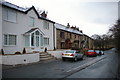
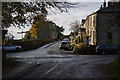
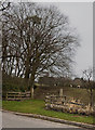
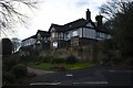
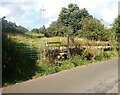
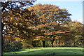
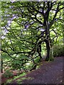
Photos of BB12 7QU


Area Information
Living in BB12 7QU means inhabiting a small, tightly knit residential cluster in the Ribble Valley, Lancashire. The area spans 10.8 hectares and is home to 1,417 residents, creating a low-density, village-like atmosphere. Situated in a historic part of England, BB12 7QU is part of the civil parish of Simonstone, a place with roots stretching back centuries. The community is defined by its quiet, rural character, with no major urban infrastructure nearby. Daily life here is shaped by proximity to local amenities, historic sites, and a strong sense of continuity. The area’s population density of 250 people per square kilometre suggests a balance between residential comfort and open space. While not a bustling town, BB12 7QU offers a peaceful alternative to larger centres, with easy access to nearby railway stations and a network of small shops. Its historical ties to families like the Cockshutt and Starkie add a layer of heritage to the modern-day village. For those seeking a slower pace of life, BB12 7QU provides a snapshot of traditional English village living, with a focus on community and local identity.
- Area Type
- Postcode
- Area Size
- 10.8 hectares
- Population
- 1417
- Population Density
- 250 people/km²
The property market in BB12 7QU is dominated by owner-occupied homes, with 78% of properties owned outright. This high rate of home ownership suggests a community of long-term residents rather than a transient rental market. The accommodation type is predominantly houses, which is typical for rural areas with lower population densities. Given the area’s small size and limited development, the housing stock is likely to be older, with many properties reflecting the historical character of Simonstone. Buyers should expect a limited selection of properties, as the area is a small residential cluster rather than a large town. The absence of significant commercial or industrial development means that property values may be influenced more by historical significance and proximity to amenities than by speculative investment. For those seeking a home in BB12 7QU, the focus is on securing a property in a stable, low-density environment with a strong sense of local identity.
House Prices in BB12 7QU
Showing 18 properties
| Address | Type | Beds | Baths | Last Sale Price | Last Sale Date | |
|---|---|---|---|---|---|---|
| 3, South View, Whins Lane, Simonstone, BB12 7QU | Cottage | 3 | 1 | £287,800 | Mar 2025 | |
| Brunlea, Whins Lane, Simonstone, BB12 7QU | Detached | 5 | 2 | £520,000 | May 2020 | |
| 2, South View, Whins Lane, Simonstone, BB12 7QU | Terraced | 2 | - | £225,000 | Aug 2018 | |
| Whinsfield, Whins Lane, Simonstone, BB12 7QU | Detached | 4 | 1 | £580,000 | Dec 2016 | |
| 1, South View, Whins Lane, Simonstone, BB12 7QU | Terraced | 3 | 1 | £290,000 | Jul 2016 | |
| 4, South View, Whins Lane, Simonstone, BB12 7QU | house | - | - | £250,000 | Feb 2013 | |
| Sandwood, Whins Lane, Simonstone, BB12 7QU | Detached | 4 | 2 | £230,000 | May 2001 | |
| 6, South View, Whins Lane, Simonstone, BB12 7QU | house | - | - | £57,500 | Jul 1995 | |
| High Lea Cottage, Whins Lane, Simonstone, BB12 7QU | Bungalow | 2 | 2 | - | - | |
| Rock Bottom, Whins Lane, Simonstone, BB12 7QU | house | - | - | - | - |
Energy Efficiency in BB12 7QU
The lifestyle in BB12 7QU is defined by its proximity to small, practical amenities. Within reach are five retail outlets, including Spar, Lidl Padiham, and Tesco Padiham, offering everyday shopping needs. These stores cater to a community that values convenience without the bustle of larger retail centres. The area’s rural character means that leisure and recreational facilities are limited to local parks and green spaces, though no specific names are provided in the data. The presence of listed buildings and historic sites, such as Gawthorpe Hall, adds cultural value to daily life. Residents benefit from a quiet, low-density environment where community ties are likely strong. While the area lacks large-scale entertainment options, the nearby railway stations provide access to broader cultural and social opportunities. The lifestyle in BB12 7QU is one of simplicity, with a focus on local connections and historical continuity.
Amenities
Schools
Residents of BB12 7QU have access to two primary schools within practical reach: Read St John’s CofE Primary School and Simonstone St Peter’s Church of England Primary School. Both institutions are rated “good” by Ofsted, indicating a reliable standard of education for younger children. The presence of two primary schools suggests that the area supports families with young children, though no secondary schools are listed in the data. The mix of church-affiliated schools may appeal to families seeking a faith-based educational environment. However, the absence of secondary education options means that students would need to travel to nearby towns for further schooling. This could be a consideration for families planning long-term residency. The quality of primary education in the area, combined with its rural setting, positions BB12 7QU as a viable option for those prioritising family-friendly schooling and a quiet environment.
| Rank | School | Type | Entry gender | Ages |
|---|
Explore more schools in this area
Go to Schools tabDemographics
The population of BB12 7QU has a median age of 47, with the majority of residents falling within the 30–64 age range. This suggests a community skewed towards adults, likely with established careers and families. Home ownership is high at 78%, indicating a stable, long-term resident base rather than a transient rental market. The predominant accommodation type is houses, which aligns with the area’s rural character and lower population density. The predominant ethnic group is White, reflecting the broader demographic patterns of rural England. While no specific data on deprivation or diversity is provided, the high home ownership rate and age profile suggest a community with relatively stable economic conditions. The absence of significant demographic diversity may impact the range of cultural amenities available, though the area’s historical and social cohesion appears intact. This profile positions BB12 7QU as a place for those prioritising stability, space, and a connection to local heritage over urban dynamism.
Household Size
Accommodation Type
Tenure
Ethnic Group
Religion
Household Composition
Age
Household Deprivation
NS-SEC
Explore more demographic insights in this area
Go to Demographics tabPlanning
Planning Constraints
- Flood RiskPremium
- Ramsar Wetland SitesPremium
- Area of Outstanding Natural BeautyPremium
- Protected Nature ReservePremium
- Protected WoodlandPremium