Area Overview for TS12 2PJ
Photos of TS12 2PJ

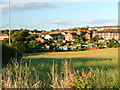
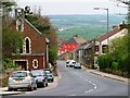
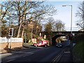
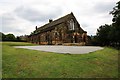

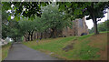
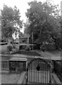
35 photos from this area
Area Information
Key information about the TS12 2PJ including its size, population, and administrative classification.
- Area Type
- Postcode
- Area Size
- 8.3 hectares
- Population
- 1222
- Population Density
- 236 people/km²
House Prices in TS12 2PJ
34
Properties
£203,897
Average Sold Price
£53,000
Lowest Price
£410,000
Highest Price
Showing 34 properties
| Address | Type | Beds | Baths | Last Sale Price | Last Sale Date | |
|---|---|---|---|---|---|---|
| Redroofs, Saltburn Road, Brotton, TS12 2PJ | house | - | - | £160,000 | Nov 2023 | |
| Freebrough, Saltburn Road, Brotton, TS12 2PJ | Bungalow | 3 | 2 | £266,500 | Mar 2022 | |
| Lyncot, Saltburn Road, Brotton, TS12 2PJ | Detached | 4 | 3 | £305,000 | Aug 2020 | |
| Springbank, Saltburn Road, Brotton, TS12 2PJ | Bungalow | - | - | £220,000 | Mar 2019 | |
| Hill Top Bungalow, Saltburn Road, Brotton, TS12 2PJ | Bungalow | 2 | 1 | £237,500 | Sep 2018 | |
| Delrayne, Hunley Avenue, Brotton, TS12 2PJ | Bungalow | 3 | - | £245,000 | Feb 2018 | |
| The Chine, Saltburn Road, Brotton, TS12 2PJ | Bungalow | 4 | 2 | £145,000 | May 2015 | |
| Windrush, Saltburn Road, Brotton, TS12 2PJ | Detached | - | - | £410,000 | Jan 2015 | |
| Craigs Cottage, Saltburn Road, Brotton, TS12 2PJ | Bungalow | - | - | £155,000 | Sep 2014 | |
| Old School, Saltburn Road, Brotton, TS12 2PJ | Bungalow | - | - | £250,000 | Apr 2011 |
Page 1 of 4
Energy Efficiency in TS12 2PJ
Amenities
Schools
| Rank | School | Type | Entry gender | Ages |
|---|
Explore more schools in this area
Go to Schools tabDemographics
Household Size
Two person
most common
Accommodation Type
Houses
most common
Tenure
91
majority
Ethnic Group
White
most common
Religion
N/A
most common
Household Composition
N/A
most common
Age
47
median
Adults (30-64 years)
most common
Household Deprivation
N/A
with no deprivation
NS-SEC
27
in Lower managerial occupations
Explore more demographic insights in this area
Go to Demographics tabPlanning
Planning Constraints
- Flood RiskPremium
- Ramsar Wetland SitesPremium
- Area of Outstanding Natural BeautyPremium
- Protected Nature ReservePremium
- Protected WoodlandPremium