Area Overview for NE8 4AY
Photos of NE8 4AY
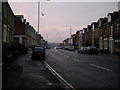
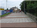
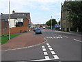

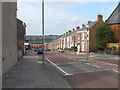
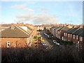

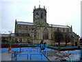
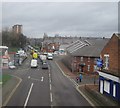
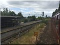

67 photos from this area
Area Information
Key information about the NE8 4AY including its size, population, and administrative classification.
- Area Type
- Postcode
- Area Size
- 1262 m²
- Population
- 1466
- Population Density
- 11851 people/km²
House Prices in NE8 4AY
23
Properties
£187,030
Average Sold Price
£174,995
Lowest Price
£205,200
Highest Price
Showing 23 properties
| Address | Type | Beds | Baths | Last Sale Price | Last Sale Date | |
|---|---|---|---|---|---|---|
| 1, St Chads View, Rawling Road, Bensham, Gateshead, NE8 4AY | Detached | 3 | 2 | £202,000 | Nov 2025 | |
| 3, St Chads View, Rawling Road, Bensham, Gateshead, NE8 4AY | Semi-detached | 3 | 2 | £205,200 | Jun 2024 | |
| 6, St Chads View, Rawling Road, Bensham, Gateshead, NE8 4AY | house | - | - | £174,995 | Mar 2021 | |
| 2, St Chads View, Rawling Road, Bensham, Gateshead, NE8 4AY | house | - | - | £179,995 | Jan 2021 | |
| 4, St Chads View, Rawling Road, Bensham, Gateshead, NE8 4AY | Detached | 3 | 2 | £179,995 | Dec 2020 | |
| 5, St Chads View, Rawling Road, Bensham, Gateshead, NE8 4AY | Detached | 3 | 2 | £179,995 | Dec 2020 | |
| 86 Westminster Street, Bensham, Gateshead, NE8 4AY | Flat | - | - | - | - | |
| 88 Westminster Street, Bensham, Gateshead, NE8 4AY | Flat | - | - | - | - | |
| 84 Westminster Street, Bensham, Gateshead, NE8 4AY | Flat | - | - | - | - | |
| 69 Dunsmuir Grove, Bensham, Gateshead, NE8 4AY | Flat | - | - | - | - |
Page 1 of 3
Energy Efficiency in NE8 4AY
Amenities
Schools
| Rank | School | Type | Entry gender | Ages |
|---|
Explore more schools in this area
Go to Schools tabDemographics
Household Size
One person
most common
Accommodation Type
Flats
most common
Tenure
35
majority
Ethnic Group
White
most common
Religion
N/A
most common
Household Composition
N/A
most common
Age
47
median
Adults (30-64 years)
most common
Household Deprivation
N/A
with no deprivation
NS-SEC
28
in Lower managerial occupations
Explore more demographic insights in this area
Go to Demographics tabPlanning
Planning Constraints
- Flood RiskPremium
- Ramsar Wetland SitesPremium
- Area of Outstanding Natural BeautyPremium
- Protected Nature ReservePremium
- Protected WoodlandPremium