Area Overview for NE40 3LU
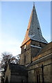
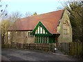
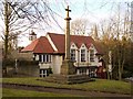
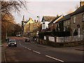
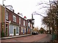
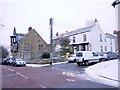
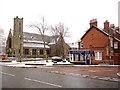
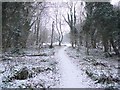
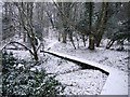
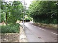
Photos of NE40 3LU

Area Information
Living in NE40 3LU offers a compact, residential experience within a small cluster of 1.4 hectares, home to 1,425 residents. The area’s high population density—103,197 people per square kilometre—reflects its tightly knit nature, where homes are closely spaced. This postcode is defined by its proximity to key transport links, including rail stations such as Blaydon and Wylam, and nearby Newcastle Airport, making it convenient for commuters. The community is predominantly composed of adults aged 30–64, with a median age of 47, suggesting a mature, stable demographic. Most residents own their homes, with 67% of properties in private ownership, and the area is characterised by houses rather than flats. Daily life here balances local amenities—such as Co-op Ryton and Morrisons—with the quietude of a small residential setting. While the area lacks natural reserves or protected landscapes, its safety record and connectivity make it appealing for those seeking a secure, practical location near transport hubs and retail.
- Area Type
- Postcode
- Area Size
- 1.4 hectares
- Population
- 1425
- Population Density
- 3196 people/km²
The property market in NE40 3LU is dominated by owner-occupied homes, with 67% of properties in private hands. This contrasts with the 33% rented, suggesting a community focused on long-term residency rather than short-term tenancies. The area’s housing stock consists entirely of houses, with no flats or apartments, which may appeal to families or those seeking traditional living arrangements. Given the small size of the postcode—just 1.4 hectares—the housing stock is limited, meaning buyers should consider nearby areas for more options. The high home ownership rate indicates strong local demand, potentially supporting property values. However, the compact nature of the area means competition for available homes may be fierce, particularly for those seeking larger properties or specific features. Buyers should also note the proximity to transport links, which could enhance the area’s appeal for commuters.
House Prices in NE40 3LU
Showing 23 properties
| Address | Type | Beds | Baths | Last Sale Price | Last Sale Date | |
|---|---|---|---|---|---|---|
| Red Lodge, 21 Grange Road, Ryton Central, Ryton, NE40 3LU | Semi-detached | 4 | 2 | £517,500 | Mar 2023 | |
| Lockhaugh, Grange Road, Ryton Central, Ryton, NE40 3LU | Semi-detached | 3 | 1 | £334,000 | Dec 2022 | |
| 35 Grange Road, Ryton Central, Ryton, NE40 3LU | Detached | 4 | 2 | £485,000 | Feb 2019 | |
| The Dales, 23 Grange Road, Ryton Central, Ryton, NE40 3LU | Semi-detached | 6 | 2 | £446,500 | Mar 2018 | |
| Brackenrigg, Grange Road, Ryton Central, Ryton, NE40 3LU | Semi-detached | 3 | 1 | £278,000 | Jun 2017 | |
| Uplands, 39 Grange Road, Ryton Central, Ryton, NE40 3LU | house | 5 | - | £415,000 | Nov 2011 | |
| 33 Grange Road, Ryton Central, Ryton, NE40 3LU | house | - | - | £490,000 | Mar 2011 | |
| Kenwood, 7 Grange Road, Ryton Central, Ryton, NE40 3LU | Semi-detached | - | - | £157,000 | Oct 2009 | |
| Orillia, 9 Grange Road, Ryton Central, Ryton, NE40 3LU | Terraced | 3 | 2 | £120,000 | Mar 2009 | |
| 29 Grange Road, Ryton Central, Ryton, NE40 3LU | house | - | - | £545,000 | Nov 2008 |
Energy Efficiency in NE40 3LU
Life in NE40 3LU is shaped by its proximity to essential amenities and transport links. Residents have access to five retail venues, including Co-op Ryton, Co-op Crawcrook, and Morrisons Daily, ensuring everyday shopping needs are met locally. The area’s rail network includes Blaydon Railway Station, Wylam Station, and Metrocentre Railway Station, while metro stops such as Callerton Parkway provide easy access to nearby towns. For air travel, Newcastle Airport is within reach, adding to the area’s connectivity. The compact size of the postcode means these amenities are all within a short distance, fostering a convenient lifestyle. While the area lacks large parks or leisure facilities, its residential character and transport links make it ideal for those prioritising accessibility over expansive green spaces. The presence of multiple retail and transport options ensures daily life is practical and efficient.
Amenities
Schools
| Rank | School | Type | Entry gender | Ages |
|---|
Explore more schools in this area
Go to Schools tabDemographics
NE40 3LU’s population is predominantly composed of adults aged 30–64, with a median age of 47, indicating a mature, established community. The area’s 1,425 residents are largely home owners, with 67% of properties privately owned, while 33% are rented. This suggests a stable housing market with a focus on long-term occupancy. The accommodation type is exclusively houses, reflecting a lack of high-density housing or flats. The predominant ethnic group is White, though the data does not specify further diversity metrics. The high population density—103,197 people per square kilometre—means the area is densely populated despite its small size, which could influence local services and social dynamics. While no deprivation data is provided, the high home ownership rate and low crime risk imply a relatively affluent and secure environment.
Household Size
Accommodation Type
Tenure
Ethnic Group
Religion
Household Composition
Age
Household Deprivation
NS-SEC
Explore more demographic insights in this area
Go to Demographics tabPlanning
Planning Constraints
- Flood RiskPremium
- Ramsar Wetland SitesPremium
- Area of Outstanding Natural BeautyPremium
- Protected Nature ReservePremium
- Protected WoodlandPremium