Area Overview for NE4 9PN
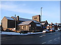
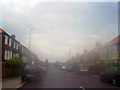
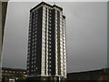
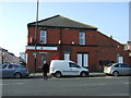
Photos of NE4 9PN

Area Information
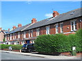
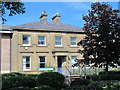
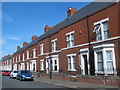
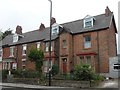
NE4 9PN is a small, densely populated residential area in England, covering 3,150 square metres and home to 1,953 residents. Its compact size means it is a tightly knit community, with a high population density of 620,034 people per square kilometre. This postcode area is characterised by its cluster of homes, predominantly occupied by adults aged 30–64, reflecting a mature demographic. The area is not defined by sprawling suburbs but by a focused residential layout, making it a practical choice for those seeking proximity to local services and transport links. While it lacks large-scale amenities, its small footprint ensures residents are within walking or short driving distance of essential facilities. The presence of independent schools and multiple transport options suggests a balance between convenience and accessibility. However, its size also means the community is intimate, with limited space for expansion. For buyers, this area offers a snapshot of urban living, where density and proximity to infrastructure are prioritised over open space.
- Area Type
- Postcode
- Area Size
- 3150 m²
- Population
- 1953
- Population Density
- 620034 people/km²
The property market in NE4 9PN is defined by a 47% home ownership rate, suggesting a balance between owner-occupied properties and rentals. The area is dominated by houses rather than flats, which is notable given its high population density. This mix implies a community where larger homes are in demand, possibly catering to families or those seeking more space than typical urban housing allows. The small size of the area means the housing stock is limited, which could affect availability for buyers. For those seeking rental properties, the proportion of lettings suggests a steady market, though the lack of specific data on property prices or trends means buyers must consider the area’s constraints. The predominance of houses may appeal to those prioritising space over proximity to central amenities, but the compact nature of NE4 9PN means expansion is unlikely.
House Prices in NE4 9PN
Showing 35 properties
Energy Efficiency in NE4 9PN
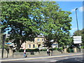
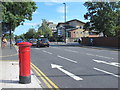
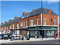
Daily life in NE4 9PN is shaped by its proximity to retail, transport, and essential services. The area’s retail offerings include Asda Benwell, Asda Benwell (duplicated), and Tesco Fenham W, providing residents with nearby shopping options. Multiple metro stations, such as St James and Central Station, along with rail links to Manors and Dunston, ensure easy access to public transport. The presence of Newcastle Airport within reach adds to the area’s connectivity. While there are no named parks or leisure facilities in the data, the rail and metro stations suggest opportunities for nearby recreation. The compact layout means residents can access these amenities without long commutes, contributing to a convenient lifestyle. The mix of retail, transport, and infrastructure makes NE4 9PN a practical choice for those prioritising accessibility over expansive amenities.
Amenities
Schools
Residents of NE4 9PN have access to two notable schools: St Michael’s RC Junior School, a primary institution, and Grainger Grammar School, an independent secondary school. The presence of both state and independent options provides families with choices, though the independent school may cater to a specific demographic. St Michael’s RC Junior School is likely to serve the local primary needs, while Grainger Grammar’s independent status suggests it may attract students from broader areas. The mix of school types reflects a community where educational preferences vary, from state-run institutions to privately funded options. However, no Ofsted ratings or academic performance data are provided, so parents must assess these schools based on other factors. For families, the availability of both school types could be a key consideration in deciding whether NE4 9PN meets their educational requirements.
| Rank | School | Type | Entry gender | Ages |
|---|
Explore more schools in this area
Go to Schools tabDemographics
The population of NE4 9PN is predominantly adults aged 30–64, with a median age of 47. This suggests a community of established professionals and families, rather than a younger or elderly demographic. Home ownership sits at 47%, indicating a mix of owner-occupied and rental properties. The area is characterised by houses rather than flats, which is uncommon in high-density urban settings. The predominant ethnic group is Asian, reflecting a specific cultural composition. While no deprivation data is provided, the high population density and mix of housing types suggest a community that is both stable and diverse. The age profile implies a focus on long-term residency, with fewer transient populations. For buyers, this demographic profile may influence local services and amenities, tailored to the needs of middle-aged residents. The absence of specific data on deprivation means the quality of life here must be inferred from the available statistics.
Household Size
Accommodation Type
Tenure
Ethnic Group
Religion
Household Composition
Age
Household Deprivation
NS-SEC
Explore more demographic insights in this area
Go to Demographics tabPlanning
Planning Constraints
- Flood RiskPremium
- Ramsar Wetland SitesPremium
- Area of Outstanding Natural BeautyPremium
- Protected Nature ReservePremium
- Protected WoodlandPremium