Area Overview for NE32 3HJ
Photos of NE32 3HJ


Area Information
Living in NE32 3HJ means inhabiting a compact residential cluster in England, where 1,224 people reside across 6,312 square metres. The area’s high population density — 1,172 people per square kilometre — reflects its small, tightly knit character. This postcode is defined by its proximity to local amenities, including schools, retail hubs, and transport links. The community is predominantly composed of adults aged 30–64, with a median age of 47. While the area lacks large-scale infrastructure, its accessibility to nearby towns and cities via rail and ferry services offers a balance between local convenience and regional connectivity. The presence of five primary schools and a nursery underscores its appeal to families, while the broadband score of 96 ensures reliable internet for remote work or study. However, the area’s high crime risk score of 4 — above average — means residents should consider security measures. NE32 3HJ is a place where daily life revolves around community hubs, practical living, and proximity to essential services.
- Area Type
- Postcode
- Area Size
- 6312 m²
- Population
- 1224
- Population Density
- 1172 people/km²
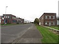
The property market in NE32 3HJ is characterised by a low home ownership rate of 33%, indicating that most residents are renters rather than homeowners. The accommodation type is predominantly houses, which is unusual for an area of this size, suggesting a mix of older, standalone properties. This configuration may limit the availability of new builds or modern developments, making the housing stock relatively static. Buyers seeking homes in NE32 3HJ will find a small, limited inventory, with little scope for investment in new construction. The area’s compact nature means that properties are likely to be close to local amenities, but the low ownership rate may reflect affordability challenges or a preference for rental living. For those considering purchasing, the market demands careful scrutiny of available listings, as the small footprint of the area means competition for properties is likely to be keen.
House Prices in NE32 3HJ
Showing 1 properties
| Address | Type | Beds | Baths | Last Sale Price | Last Sale Date | |
|---|---|---|---|---|---|---|
| Bede Metro Station, Monksway, Jarrow, NE32 3HJ | commercial | - | - | - | - |
Energy Efficiency in NE32 3HJ
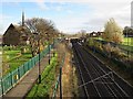
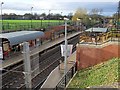
Daily life in NE32 3HJ is shaped by its proximity to a range of amenities. The area’s retail options include major supermarkets such as Tesco South, Asda Simonside, and Sainsburys Simonside, ensuring easy access to groceries and everyday essentials. Metro stations like Bede, Simonside, and Tyne Dock provide links to urban centres, while rail services connect to Heworth, East Boldon, and Brockley Whins. Ferry terminals at Newcastle and South Shields offer additional transport choices for regional travel. The presence of five primary schools and a nursery highlights the area’s family-friendly appeal. Though the data does not specify parks or leisure facilities, the density of transport and retail options suggests a practical, convenience-driven lifestyle. Residents can enjoy a mix of local services and broader connectivity, though the compact nature of the area means amenities are concentrated within a small radius.
Amenities
Schools
The schools near NE32 3HJ include Dunn Street Nursery School, Dunn Street Primary School, and St Bede’s RC Primary School, Jarrow, along with St Bede’s Junior and Infant Schools. These institutions cater to early years education through primary schooling, offering multiple options for families. The presence of five primary schools within practical reach suggests a strong focus on local education, though no Ofsted ratings are provided in the data. The variety of school types — including a nursery and separate infant and junior schools — may indicate a structured approach to education, allowing parents to choose settings that align with their children’s needs. For families prioritising proximity to schools, NE32 3HJ’s cluster of educational institutions is a clear advantage. However, the absence of secondary schools in the data means residents may need to look further afield for higher education.
| Rank | School | Type | Entry gender | Ages |
|---|
Explore more schools in this area
Go to Schools tabDemographics
The population of NE32 3HJ is 1,224, with a median age of 47. The majority of residents fall within the 30–64 age range, reflecting a mature, established community. Home ownership rates are low at 33%, suggesting that most residents rent their properties. The accommodation type is primarily houses, which is uncommon in densely populated areas, indicating a mix of older, standalone homes. The predominant ethnic group is White, with no specific data on other demographics provided. The high population density — 1,172 people per square kilometre — means the area is compact, with limited space for expansion. This density, combined with the age profile, suggests a stable, long-term resident base. However, the low home ownership rate may imply economic pressures or a transient population. For those considering living here, the demographic profile offers a snapshot of a community that prioritises practicality over luxury.
Household Size
Accommodation Type
Tenure
Ethnic Group
Religion
Household Composition
Age
Household Deprivation
NS-SEC
Explore more demographic insights in this area
Go to Demographics tabPlanning
Planning Constraints
- Flood RiskPremium
- Ramsar Wetland SitesPremium
- Area of Outstanding Natural BeautyPremium
- Protected Nature ReservePremium
- Protected WoodlandPremium