Area Overview for SE6 1PF
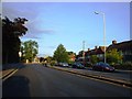
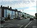
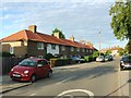
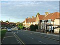
Photos of SE6 1PF
Area Information
Living in SE6 1PF defines daily life within Hither Green, a district in south-east London located in the London Borough of Lewisham. This small residential cluster spans just 1.0 hectares and houses a population of 1,750 people within a dense footprint. The area sits where the Prime Meridian crosses through the pedestrian tunnel at Hither Green Station, with most of the district lying in the western hemisphere. Hither Green acquired its name because it was closer to Lewisham than "Further Green" located on Verdant Lane. The original settlement is thought to have been a medieval hamlet called Romborough, which was destroyed by the Black Death. By the late 19th century, the area transformed from rural land into a suburban district characterised by late Victorian and Edwardian domestic architecture. This specific postcode area represents that historic transition, offering residents a compact environment where homes were built following the pivotal moment in the area's development when Hither Green Station opened on 1 June 1895. The architecture and layout reflect the work of Scottish developer Archibald Cameron Corbett, who purchased the land and began building houses on what became known as the Corbett Estate from 1896 onwards.
- Area Type
- Postcode
- Area Size
- 1.0 hectares
- Population
- 1750
- Population Density
- 12246 people/km²
The property market in SE6 1PF is dominated by rental living, with home ownership rates sitting at only 15%. This low percentage implies that the vast majority of the 1,750 residents living in this 1-hectare area are tenants rather than owners. The predominant accommodation type is flats, which fits the high population density of 168,200 people per square kilometre. This housing stock predates many modern developments, rooted in the late 19th and early 20th century Victorian and Edwardian architecture developed by Corbett from 1896 onwards. For anyone looking at homes in SE6 1PF, the search will likely focus on leasehold flats within established blocks or convertings on the Corbett Estate. The area lacks public houses, a legacy of the developer's Quaker origins and temperance convictions. Consequently, the property market here is less about large detached family homes with private gardens and more about efficient, multi-occupancy living spaces. Buyers interested in purchasing should look to the wider Lewisham borough or consider the rarity of purchasing in this specific postcode cluster, where the market is driven by investment or renting rather than owner-occupier demand. The high density suggests that amenities are within walking distance, reducing the need for expansive private grounds that characterise outer London suburbs.
House Prices in SE6 1PF
Showing 44 properties
| Address | Type | Beds | Baths | Last Sale Price | Last Sale Date | |
|---|---|---|---|---|---|---|
| 110 Boundfield Road, London, SE6 1PF | house | - | - | £407,000 | Nov 2021 | |
| 94 Boundfield Road, London, SE6 1PF | Terraced | 2 | - | £365,000 | Jul 2019 | |
| 74 Boundfield Road, London, SE6 1PF | Flat | 2 | - | £260,000 | Dec 2018 | |
| 98 Boundfield Road, London, SE6 1PF | house | - | - | £240,000 | Nov 2014 | |
| 96 Boundfield Road, London, SE6 1PF | house | - | - | £235,000 | Sep 2011 | |
| 90 Boundfield Road, London, SE6 1PF | house | - | - | £220,000 | Jun 2007 | |
| 105 Boundfield Road, London, SE6 1PF | Terraced | - | - | £176,000 | Nov 2006 | |
| 117 Boundfield Road, London, SE6 1PF | house | - | - | £180,000 | Jun 2006 | |
| 78 Boundfield Road, London, SE6 1PF | Flat | - | - | £120,000 | Dec 2005 | |
| 72 Boundfield Road, London, SE6 1PF | Flat | - | - | £130,000 | Oct 2005 |
Energy Efficiency in SE6 1PF
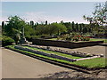
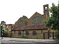
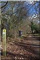
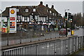
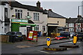
The lifestyle in SE6 1PF centres on accessible retail and transport hubs rather than traditional leisure quarters. Five retail outlets are within practical reach, including Budgens Catford, Co-op Downham, and Tesco Grove, providing essential shopping for daily needs. Transport convenience is maximised with five train stations, five tram stops, and five ferry piers all nearby. Specific venues include Grove Park Station, Bellingham Station, Lee, Elverson Road, Beckenham Road Tram Stop, and Deptford Bridge. Ferry services connect to Greenwich Pier, Masthouse Terrace Pier, and Royal Wharf Pier. London City Airport is also nearby. For recreation, Mountsfield Park stands out as a notable feature. It opened in August 1905 on the grounds of the former Mountsfield house and has expanded to 28 acres. The park's history includes acquisitions from bomb-damaged terraces and Charlton Athletic's former football ground in 1923. St Andrew's Church was built on land donated by Corbett and dedicated to Scotland's patron saint. The area characterised by late 19th and early 20th century Victorian and Edwardian domestic architecture, particularly on the Corbett Estate. The railway divides the area into an east side focused on Staplehurst Road and a west side focused on Hither Green Lane and Springbank Road. Many road names are of Scottish origin, reflecting Corbett's Scottish heritage.
Amenities
Schools
Families considering schools near SE6 1PF have access to Forster Park Primary School, which holds an Ofsted rating of good. This institution serves the educational needs of younger children within the immediate vicinity of the postcode. The school's good rating provides a foundation for early education, though the single school entry suggests that families with older children may need to look to adjacent areas in Lewisham, as no secondary schools are listed directly in this small residential cluster. The presence of a primary school with a good rating indicates that the immediate neighbourhood supports the younger demographic, even if the resident population median age of 47 suggests many households already have school-age children. Parents should note that while Forster Park Primary School is close by, the diversity of educational options is limited within this specific 1-hectare zone. The school mix is functional rather than extensive, reflecting the compact nature of Hither Green where residents often access broader secondary education networks further afield. For those prioritising education, the good rating at Forster Park Primary School is a key positive fact when evaluating the locality for children's schooling.
| Rank | School | Type | Entry gender | Ages |
|---|
Explore more schools in this area
Go to Schools tabDemographics
The community in SE6 1PF is defined by a median age of 47 years, with Adults aged 30 to 64 years representing the most common age range. This demographic profile indicates a mature neighbourhood where established families and long-term residents form the backbone of society. Home ownership stands at 15%, which signifies that the majority of the 1,750 residents rent their accommodation rather than own it outright. The predominant accommodation type consists of flats, aligning with the high population density of 168,200 people per square kilometre. This density creates a shared living environment typical of urban London postcodes. The most common ethnic group in the area is Black, contributing to a distinctive cultural character within this specific 1-hectare zone. While the population is relatively small compared to broader boroughs, the concentration of residents in flat-style housing means neighbourly interactions often happen in shared corridors and local communal spaces. The age distribution suggests that services and amenities must cater to a significant number of middle-aged adults, influencing everything from local business hours to the types of recreational facilities available near Grove Park.
Household Size
Accommodation Type
Tenure
Ethnic Group
Religion
Household Composition
Age
Household Deprivation
NS-SEC
Explore more demographic insights in this area
Go to Demographics tabPlanning
Planning Constraints
- Flood RiskPremium
- Ramsar Wetland SitesPremium
- Area of Outstanding Natural BeautyPremium
- Protected Nature ReservePremium
- Protected WoodlandPremium