Area Overview for SE12 9TP
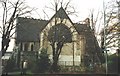
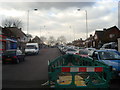
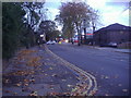
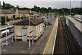
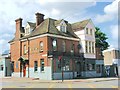
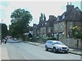
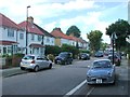
Photos of SE12 9TP

Area Information
SE12 9TP represents a specific residential cluster within South-East London, defined by its compact footprint of 4,409 square metres. This postcode covers a small population of 1,646 residents, creating a tightly knit environment where neighbours are likely to know one another. The area functions as a dense pocket of urban living, balancing the constraints of its limited physical size with the needs of a local community. You will find this postcode operates as a distinct neighbourhood rather than a sprawling locality, which naturally influences the pace of daily life and how spaces are utilised. Living in SE12 9TP means accepting a high-density lifestyle within a confined space. The sheer number of people relative to the land area suggests a neighbourhood where property values compete for every available plot. This specific cluster sits near significant transport hubs and commercial zones, making it a practical choice for those who prioritise accessibility over expansive gardens. The area does not offer the privacy of a detached house estate but provides the convenience of being close to major employment centres and leisure facilities. It is a place where the immediate surroundings dominate your view, and the character of the streets is shaped by its history and its current role as a thoroughfare for local traffic.
- Area Type
- Postcode
- Area Size
- 4409 m²
- Population
- 1646
- Population Density
- 7135 people/km²
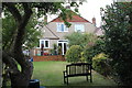
The property market in SE12 9TP is defined by a high concentration of flats, which constitutes the entire accommodation type within this postcode. This structural characteristic limits buyer options significantly compared to broader areas like SE12 9DN or SE12 9ET, where detached homes might be available. Only 41% of homes in this cluster are owner-occupied, suggesting a significant portion of the housing stock is let by landladies or is part of shared ownership schemes. The remaining 59% implies a strong presence of tenants, reflecting a market where purchase market demand faces competition from the rental sector. You will find that三房式 or one-bedroom flats are the most likely configurations available here, designed to maximise use of the limited 4,409 square metres of land. This area is not a typical family estate with spacious gardens; it is a vertical living environment where value is derived from location rather than square footage. Buyers looking specifically for the SE12 9TP postcode need to adjust their expectations regarding space and garden access. The area appeals to professionals or downsizers who prioritise proximity to London stations over traditional suburban comforts. The dominance of flats means that character homes are found within the flat buildings themselves, potentially as purpose-built units rather than converted period properties.
House Prices in SE12 9TP
Showing 30 properties
| Address | Type | Beds | Baths | Last Sale Price | Last Sale Date | |
|---|---|---|---|---|---|---|
| 20 Amblecote Close, Grove Park, London, SE12 9TP | Flat | - | - | £295,000 | Jan 2023 | |
| 13 Amblecote Close, Grove Park, London, SE12 9TP | Flat | 2 | 1 | £250,000 | Sep 2022 | |
| 6 Amblecote Close, Grove Park, London, SE12 9TP | Flat | - | - | £258,000 | Sep 2021 | |
| 15 Amblecote Close, Grove Park, London, SE12 9TP | Flat | - | - | £275,000 | Apr 2021 | |
| 3 Amblecote Close, Grove Park, London, SE12 9TP | Flat | - | - | £280,000 | Apr 2021 | |
| 24 Amblecote Close, Grove Park, London, SE12 9TP | Flat | - | - | £255,000 | Jul 2020 | |
| 18 Amblecote Close, Grove Park, London, SE12 9TP | Flat | - | - | £225,000 | Nov 2019 | |
| 7 Amblecote Close, Grove Park, London, SE12 9TP | Flat | - | - | £187,000 | Apr 2019 | |
| 10 Amblecote Close, Grove Park, London, SE12 9TP | Flat | - | - | £263,000 | Oct 2017 | |
| 26 Amblecote Close, Grove Park, London, SE12 9TP | Flat | - | - | £231,000 | Jan 2016 |
Energy Efficiency in SE12 9TP
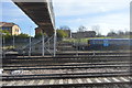
Daily life in SE12 9TP is supported by a network of local amenities that are within practical reach of every resident. For grocery shopping, you can visit Sainsburys Lewisham Grove, Tesco Grove, or the Co-op Downham, all of which are listed as notable local establishments. These retailers provide weekly necessities without requiring a drive, fitting seamlessly into a flat-based lifestyle. Transport and leisure options are diverse. There are five rail stations, five metro stops, and five ferry points offering extensive travel choices. London City Airport is also listed as a nearby facility, suggesting the area appeals to business travellers. While there is no mention of a local cinema, theatre, or major park in the immediate data, the five tram stops and tram lines like Beckenham Road and Avenue Road indicate a focus on light public transport. The presence of Greenwich Pier and Masthouse Terrace Pier suggests access to riverside views and water transport from nearby locations. Living here means relying on these five key transport hubs and three main supermarkets for your weekly routine. The character of the area centres on convenience and accessibility rather than a village-like community feel with local pubs and cafes within the immediate postcode boundary.
Amenities
Schools
| Rank | School | Type | Entry gender | Ages |
|---|
Explore more schools in this area
Go to Schools tabDemographics
The community within SE12 9TP is characterised by a mature demographic profile, with a median age of 47 years. The majority of residents fall into the adult bracket between 30 and 64 years old, indicating an area predominantly populated by families and established individuals rather than young students or retirees. This age distribution suggests a neighbourhood focused on stability and long-term residency. Positioned as a post-war housing estate or similar initiative, the area reflects a generation that values homeownership, evidenced by a 41% home ownership rate. The predominant ethnic group in SE12 9TP is White, which aligns with the historical development patterns of this part of South-East London. The area is exclusively made up of flats, meaning detached and semi-detached homes are not an option for buyers looking at this specific postcode. Accommodation here is designed for efficient living within a small footprint, catering to individuals and couples who opt for flat life over house ownership. With a population density reaching 373,327 people per square kilometre, the environment is intensely urban. You are immersed in a compact living space where noise and neighbourly proximity are inherent features of the housing stock. The community feels established, with long-term residents comprising the core demographic.
Household Size
Accommodation Type
Tenure
Ethnic Group
Religion
Household Composition
Age
Household Deprivation
NS-SEC
Explore more demographic insights in this area
Go to Demographics tabPlanning
Planning Constraints
- Flood RiskPremium
- Ramsar Wetland SitesPremium
- Area of Outstanding Natural BeautyPremium
- Protected Nature ReservePremium
- Protected WoodlandPremium